- Mankato Township, Blue Earth County, Minnesota
-
Mankato Township, Minnesota — Township — Location within the state of Minnesota
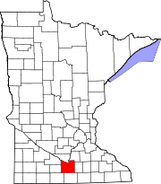
 Mankato Township, Minnesota
Coordinates: 44°8′45″N 93°57′28″W / 44.14583°N 93.95778°WCoordinates: 44°8′45″N 93°57′28″W / 44.14583°N 93.95778°W Country United States State Minnesota County Blue Earth Area - Total 29.5 sq mi (76.4 km2) - Land 28.9 sq mi (74.9 km2) - Water 0.6 sq mi (1.6 km2) Elevation 961 ft (293 m) Population (2000) - Total 1,833 - Density 63.4/sq mi (24.5/km2) Time zone Central (CST) (UTC-6) - Summer (DST) CDT (UTC-5) ZIP codes 56001-56002 Area code(s) 507 FIPS code 27-39896[1] GNIS feature ID 0664891[2] Mankato Township is a township in Blue Earth County, Minnesota, United States. The population was 1,833 as of the 2000 census.[3]
Contents
Geography
According to the United States Census Bureau, the township has a total area of 29.5 square miles (76.4 km²), of which 28.9 square miles (74.9 km²) is land and 0.6 square miles (1.6 km²) (2.07%) is water.
The southeast three-quarters of the city of Mankato and the west half of the city of Eagle Lake are within the township geographically, as is as the entire city of Skyline. All are separate entities from the township.
Unincorporated towns
- Belle Haven at 44°09′56″N 93°57′41″W / 44.1655222°N 93.9613434°W
- University Park of Mankato at 44°08′30″N 93°59′11″W / 44.141633°N 93.9863436°W
(This list is based on USGS data and may include former settlements.)
Major highways
Lakes
- Eagle Lake
Adjacent townships
- Lime Township (north)
- Jamestown Township (northeast)
- Le Ray Township (east)
- McPherson Township (southeast)
- Decoria Township (south)
- Rapidan Township (southwest)
- South Bend Township (west)
Cemeteries
The township contains these ten cemeteries: Bunker Hill, Calvary, Glenwood, Good Counsel, Grand View Memorial, Mankato, Old Masonic, Sibley Mound, Tivoli and Woodland Hills Memorial Park.
Demographics
As of the census[1] of 2000, there were 1,833 people, 626 households, and 520 families residing in the township. The population density was 63.4 people per square mile (24.5/km²). There were 636 housing units at an average density of 22.0/sq mi (8.5/km²). The racial makeup of the township was 98.09% White, 0.38% African American, 0.11% Native American, 0.87% Asian, 0.16% from other races, and 0.38% from two or more races. Hispanic or Latino of any race were 0.38% of the population.
There were 626 households out of which 42.8% had children under the age of 18 living with them, 75.7% were married couples living together, 4.3% had a female householder with no husband present, and 16.8% were non-families. 13.1% of all households were made up of individuals and 5.4% had someone living alone who was 65 years of age or older. The average household size was 2.92 and the average family size was 3.19.
In the township the population was spread out with 29.9% under the age of 18, 6.8% from 18 to 24, 26.4% from 25 to 44, 28.3% from 45 to 64, and 8.7% who were 65 years of age or older. The median age was 39 years. For every 100 females there were 104.8 males. For every 100 females age 18 and over, there were 102.0 males.
The median income for a household in the township was $64,471, and the median income for a family was $67,143. Males had a median income of $46,151 versus $28,571 for females. The per capita income for the township was $27,189. About 2.0% of families and 3.7% of the population were below the poverty line, including 4.8% of those under age 18 and 5.5% of those age 65 or over.
References
- United States National Atlas
- United States Census Bureau 2007 TIGER/Line Shapefiles
- United States Board on Geographic Names (GNIS)
- ^ a b "American FactFinder". United States Census Bureau. http://factfinder.census.gov. Retrieved 2008-01-31.
- ^ "US Board on Geographic Names". United States Geological Survey. 2007-10-25. http://geonames.usgs.gov. Retrieved 2008-01-31.
- ^ United States Census Bureau American FactFinder - Mankato Township total population
Municipalities and communities of Blue Earth County, Minnesota Cities Amboy | Eagle Lake | Good Thunder | Lake Crystal | Madison Lake | Mankato‡ | Mapleton | Minnesota Lake‡ | North Mankato‡ | Pemberton | Skyline | St. Clair | Vernon Center
Townships Beauford | Butternut Valley | Cambria | Ceresco | Danville | Decoria | Garden City | Jamestown | Judson | Le Ray | Lime | Lincoln | Lyra | Mankato | Mapleton | McPherson | Medo | Pleasant Mound | Rapidan | Shelby | South Bend | Sterling | Vernon Center
Footnotes ‡This populated place also has portions in an adjacent county or counties
Categories:- Townships in Blue Earth County, Minnesota
- Mankato – North Mankato metropolitan area


Wikimedia Foundation. 2010.