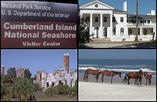
- Cumberland Island
-
For the Cumberland Islands of Northern Queensland, see Cumberland Islands.

Cumberland Island is one of the Sea Islands. Cumberland is the largest in terms of continuously exposed land area of Georgia's barrier islands. It is located on the Atlantic Ocean off the coast of the U.S. state of Georgia and is part of Camden County (30°51′N, 81°27′W). The island is 17.5 miles (28.2 km) long, with an area of 36,415 acres (147.37 km² or 56.25 square miles), including 16,850 acres (68.2 km2) of marsh, mudflats, and tidal creeks. There is no bridge to the island. Many visitors reach the island by the Cumberland Ferry; a convenient access is located in downtown St. Marys, Georgia.
Contents
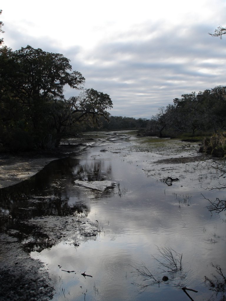
Ecology
 Marsh on Cumberland Island
The island has three major ecosystem regions. Along the western edge of the island there are large areas of salt marshes. One will also see gnarled live oak trees covered with Spanish moss and the palmetto plants at the edge of Cumberland's dense maritime forest. Cumberland Island's most famous ecosystem is its beach, which stretches over 17 miles (27 km). The island is home to many native interesting animals, as well as non-native species. There are White-tailed deer, squirrels, Raccoons, Nine-banded Armadillos, Wild Boars, American Alligators, as well as many marshland inhabitants. It is also famous for its wild horses roaming free on the island.
History
Early settlement
First inhabitants were indigenous peoples who settled there as early as 4,000 years ago. Later inhabitants participated in the Savannah archaeological culture and spoke the Timucua language. Its inhabitants were part of the Mocama, a Timucua group who spoke the Mocama dialect. In the 17th century the island and the adjacent coast were controlled by the Tacatacuru chiefdom. The main village, known as Tacatacuru, was located towards the southern end of the island; during the time of European colonization, the Spanish recorded the names of at least six more villages on the island, and eleven more were located on the mainland.
Spanish settlement
During the 16th and 17th centuries, Cumberland Island was part of the Mocama missionary province of Spanish Florida. When the Spanish arrived in 1566, they named the island San Pedro. They built a garrison and mission, San Pedro de Mocama, near the village of Tacatacuru. The mission operated from 1587 to 1660. It was one of the main mission centers, situated at a major Mocama site. Another Spanish mission on Cumberland was Puturiba, which operated from 1595–1597. An additional mission, San Phelipe, was relocated from the North Newport River to the northern end of Cumberland from 1670–1684.
Historical records indicate that until 1681, there were approximately 300 natives and several Spanish missionaries living on Cumberland Island. In 1683, French pirates attacked Cumberland Island, looting and burning many of the buildings. Many of the natives and the Spanish missionaries fled the island. An attack in 1684 by the Spanish pirate Thomas Jingle led to the final abandonment of the island. The Tacatacuru relocated closer to St. Augustine, and Cumberland Island was thereafter occupied by the Yemassi. Most of the Mocama had converted to Christianity before the island was abandoned. During the colonial years, many died of newly introduced infectious diseases, to which they had no natural immunity. Survivors retreated to St. Augustine to the south.
English settlement
English General James Oglethorpe arrived at the Georgia coast in 1733. The name of Cumberland Island was given by a young Yamacraw named Toonahowi (the nephew of Chief Tomochichi who visited England with Oglethorpe.) He suggested the island be named for William Augustus, the 13-year old Duke of Cumberland.
Oglethorpe established a hunting lodge called Dungeness, named after a headland in Kent, England. A fort was erected at the southern point of the island called Fort William. At the northern end of the island, Oglethorpe built Fort St. Andrews. For a decade the small village of Berrimacke existed near the fort. The forts were built to defend English settlements to the north from the Spanish in Florida.
After the English defeated the Spanish in Battle of Bloody Marsh in 1742, the need for the forts ended. They abandoned the forts and eventually the village disappeared. No trace remains today of Fort William, and most signs of Fort St. Andrews have been washed away.
In the 1760s, the island was divided into royal grants but saw little activity. When naturalist William Bartram visited the island in 1774, the island was mostly uninhabited.
The plantation era
Revolutionary War hero Nathaniel Greene purchased land on the island in 1783 to harvest live oaks for ship building. Wood from the island was used to build the USS Constitution, "Old Ironsides." Greene died in 1786. His wife, Catherine, remarried Phineas Miller ten years later, and they built a huge, four-story tabby mansion on top of an Indian shell mound. She named it Dungeness after Oglethorpe's hunting lodge. The mansion, with 6-foot (1.8 m) thick walls at the base, featured four chimneys and 16 fireplaces, and was surrounded by 12 acres (49,000 m2) of gardens. Dungeness was the site of many special social galas, where statesmen and military leaders enjoyed the Millers' hospitality. When the island was briefly occupied during the War of 1812, the British used Dungeness as their headquarters. They also freed the American slaves on the island.[1]
The Millers became the first major planters on the Island. They, like many others, cultivated the valuable and labor-intensive crop of Sea Island cotton. They held a total of 210 slaves to work the plantation.
In 1818, Gen. "Lighthorse" Harry Lee, a Revolutionary War hero and old friend of Nathaniel and Catherine Greene, (and the father of Confederate general Robert E. Lee.), came to Cumberland Island. He was in failing health and was returning from the West Indies when he asked to be taken to his old friend's estate of Dungeness. After a month of illness, he died on March 25 and was buried on the island. His son, Confederate General Robert E. Lee, had a tombstone placed over the grave and visited his father's final resting place several times. In 1913, the body of Harry Lee was reinterred at Lexington, Virginia, to lie beside his famous son, but his gravestone was left on Cumberland Island.
Records show that in 1846, there were 36 white people and 400 enslaved people. With the end of slavery after the Civil War and a changing economy, the plantation was not profitable. Dungeness deteriorated and the family moved away. Dungeness burned down in 1866.
The Carnegies
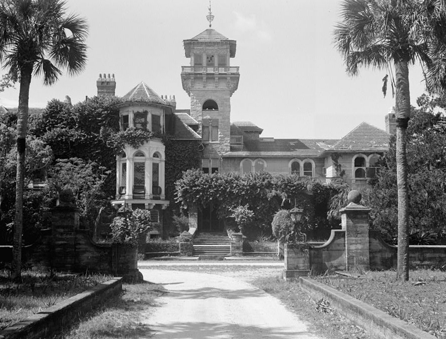
 Dungeness Mansion prior to 1959 fire on Cumberland Island National Seashore
In the 1880s Thomas M. Carnegie, brother of steel magnate Andrew Carnegie, and his wife Lucy bought land on Cumberland for a winter retreat. In 1884, they began building a mansion on the site of Dungeness, though Carnegie never lived to see its completion. Lucy and their nine children continued to live on the island, naming their mansion Dungeness after that of Greene. Dungeness was designed as a 59-room Scottish castle. They also built pools, a golf course, and 40 smaller buildings to house the 200 servants who worked at the mansion. The last time Dungeness was used was for the 1929 wedding of a Carnegie daughter. After the Crash and the Great Depression, the family left the island and kept the mansion vacant. It burned in a 1959 fire, believed to have been started by a poacher who had been shot in the leg by a caretaker weeks before. Today, the ruins of the mansion remain on the southern end of the island. The Carnegie family owned 90% of the island.
Lucy Carnegie had additional estates built on the island for her children. These include:
- Greyfield, built in 1900, now a private inn.
- Plum Orchard, donated to the National Park Service in 1972, which maintains it.
- Stafford Plantation, not currently maintained.
In the 1890s, "The Settlement" was established at the north end of the island as a residential area for black workers, as Georgia had passed laws requiring racial segregation of housing and public facilities. Discrimination may have been the basis of white workers on the plantation being paid $1 a day, while black workers received $0.50 per day; however, another reason for the discrepancy may have been that white workers were typically management or skilled labor while many of the black workers were not. The First African Baptist Church, established in The Settlement in 1893, was rebuilt in the 1930s. It is one of the few remaining structures of this community.
Present-day conservation
Further information: Cumberland Island National SeashoreIn 1954 some of the members of the Carnegie family invited the National Park Service to the island to assess its suitability as a National Seashore. In 1955 the National Park Service named Cumberland Island as one of the most significant natural areas in the United States and plans got underway to secure it. Simultaneously, the State of Georgia was working on plans to secure the island as a state park. [2] Plans to create a National Seashore were complicated when, in October 1968, Tom, Henry, and Andrew Carnegie sold three thousand acres of the island to a developer named Charles Fraser, who had developed part of Hilton Head, SC with a commitment to preserving its biodiversity and beauty. Fraser invited renowned conservationist and Sierra Club founder, David Brower, to the island to discuss how to develop the area with greatest conservation. Brower pushed for a 90/10 split, with 90% of the land to remain undeveloped. [3] However, the thought of any additional development on the island beyond the structures already erected by the Carnegies and Sam Candler, who also owned part of the island, caused activists, politicians, members of the Carnegie and Candler families, and a number of organizations, including the Georgia Conservancy and ultimately the Sierra Club, to band together and push Fraser to sell to the National Park Foundation. They, along with others, also helped push a bill through the US Congress that established Cumberland Island as a national seashore. The bill was signed by President Richard Nixon on October 23, 1971. The Carnegie family sold the island to the federal government. With donations from the Mellon Foundation, Cumberland Island became a national park. It is one of the most undeveloped places in the United States[4]
Current land ownership
Cumberland Island is really two islands—the island proper and Little Cumberland Island—connected by a marsh. Little Cumberland is privately owned and not generally open to the public. Historically, Cumberland Island was in private hands, but large areas were deeded to the National Parks Foundation by members or heirs of the Carnegie family in 1971. Other lands in private ownership were purchased with funds provided by the Mellon Foundation and Congress, and in 1972 Cumberland Island was designated a national seashore. A small number of people—principally descendants of property owners—still have houses on the western and northern regions of the island, though only a very few people actually live year-round on the island. Many, however, have sold their property to the National Park Service (NPS), which in turn leases the property back to the former landowners during their lifetime. Eventually, the property will revert to the Park Service and become part of the national seashore.
Sharks
Cumberland Island is also thought to have a high shark population. Records show that the area around Cumberland Island contains a large population of sharks. Also, there is a depression known as the "Eighty Foot Hole," just off the northern tip of Cumberland Island, which has yielded some very large sharks. Shark attacks, however, are extremely rare. In fact there has only been two attacks recorded, the most recent took place in June 2010, when a woman was lying in less than a foot and a half of water. Her wounds, which were on her wrist and hand, required many stitches, however they were not life threatening. YoSurfer.com website also lists a shark attack upon a man bathing off Cumberland Island on May 19, 2006 (he was bitten on the leg) It should also be noted that Cumberland Island beaches are relatively uncrowded, which may help account for the lower than expected incidence of shark attacks within the murky shark infested waters.
http://www.yosurfer.com/content/oceans_and_environment/shark_attack_file/all/usa/n/579
Visiting Cumberland
The public areas of Cumberland Island are part of a national seashore managed by the National Park Service. NPS restricts access to 300 people on the island at a time, and campers are allowed to stay no more than 7 nights. A ferry runs twice a day to Cumberland Island from the mainland (St. Marys, Georgia). The only other way to reach the island is by private boat. Visitors cannot bring vehicles or bikes on the ferry, and there are no paved roads or trails. Bikes are available for rent at the Sea Camp Dock, on a first-come, first-served basis. Visitors may bring their own bikes to the island via private or charter boat. Visitors walk everywhere they go, but Cumberland Island is less than six miles (10 km) wide at the widest point. The eastern seashore is 17.5 miles (28.2 km) of continuous beach. There is one camping area with running water and bathrooms with cold showers; the other camping sites do not have facilities. All food, ice and supplies must be shipped from the mainland, as there are no stores on the island.
Things to see include:
- Dungeness ruins
- Wildlife
- Ecosystems
- Feral horses and other animals
- First African Baptist Church. Maintained by the National Park Service, this simple one-room frame structure, with 11 handmade pews and three windows on each side, was built in 1937 to replace an earlier 1893 structure.
See also
References
- ^ "Cumberland Island". http://www.forgotteninvasion.com/teachers/PDF/cireading.pdf.
- ^ Creating Cumberland Island National Seashore [1]
- ^ McPhee, John (1971). Encounters with the Archdruid. New York: Farrar, Straus and Giroux. pp. 79-150. ISBN 0-374-14822-8
- ^ entirekit.indd
External links
- www.cumberlandisland.com
- Carnegie Family/Cumberland Island photograph collection (1888-1919) from the collection of the Georgia Archives.
Coordinates: 30°51′04″N 81°26′54″W / 30.85111°N 81.44833°W
Categories:- Barrier islands of Georgia (U.S. state)
- Geography of Camden County, Georgia
- St. Marys, Georgia
- Cumberland Island National Seashore

Wikimedia Foundation. 2010.