- Oleta River State Park
-
Oleta River State Park 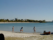
The beach at Oleta River State ParkType State Park Location North Miami, Miami, Florida, United States Area 1,043 acres (4.22 km2) Created 1986 Operated by Florida Department of Environmental Protection Website The Barnacle Historic State Park Oleta River State Park IUCN Category Ib (Wilderness Area)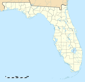

Nearest city North Miami, Florida Coordinates 25°55′08″N 80°08′24″W / 25.91889°N 80.14°WCoordinates: 25°55′08″N 80°08′24″W / 25.91889°N 80.14°W The Oleta River State Park is a 1,043-acre (4.22 km2) Florida State Park system on Biscayne Bay in the municipal suburb of North Miami in metropolitan Miami, Florida. Adjoining the Biscayne Bay Campus of Florida International University, park contains one of the largest concentrations of Australian pine (Casuarina) trees, an invasive species in the state park system.
Contents
Facilities
The central feature of this park is the mouth of the Oleta River, for which it is named. The river has drawn human inhabitants to the area since about 500 B.C, when its shores served as a campground for Tequesta Indians. It was used by U.S. troops (who called it Big Snake Creek) in 1841 during the Second Seminole War, and further explored in 1881 by Naval Captain William Hawkins Fulford, whose ventured inland to what is now the city of North Miami Beach. The area became more heavily settled in the 1890s and in 1922, developers changed the name from Big Snake Creek to the Oleta River.
The river itself no longer flows to the Everglades, but remains a popular area for canoeing. The park also boasts some of the best wilderness bike trails in the country, and is a frequent host for triathlons and other extreme sports events. There is a beach on Biscayne Bay, kayak rentals, and primitive cabins. Oleta River State Park is also the headquarters to one of the state's five AmeriCorps Florida State Parks chapters.
Health concerns
Oleta River State Park is adjacent to Munisport landfill, a former superfund site. However, no health issues at Oleta River state park have been linked to the landfill.[1]
Gallery
-

Night Heron on the Oleta River
External links
- Oleta River State Park at Florida State Parks
- Oleta River State Recreation Area at Absolutely Florida
- Oleta River State Recreation Area at Wildernet
- Oleta River State Park Mountain Bike Trail at Dirtworld.com
References
"Public Health Assessment, Munisport Landfill, North Miami, Dade County, Florida". http://www.atsdr.cdc.gov/HAC/pha/munisport/mlf_p1.html. Retrieved 2007-07-28.
Greater Miami Miami (center city) CBD Urban centers Major thoroughfares North 36th Street · North 79th Street · North 103rd Street · North 125th Street · West 7th Avenue · West 27th Avenue · West 107th Avenue · Allapattah Road · Alton Road · Bird Road · Biscayne Boulevard · Collins Avenue · Coral Reef Drive · Coral Way · County Line Road · Flagler Street · Galloway Road · Gratigny · Ives Dairy Road · Julia Tuttle Causeway · Kendall Drive · Killian · Krome Avenue · William H. Lehman Causeway · LeJeune Road · Ludlam Road · MacArthur Causeway · Miami Avenue · Miami Gardens Drive · Milam Dairy Road · Miracle Mile · Ocean Drive · Okeechobee Road · Old Cutler Road · Port Boulevard · Red Road · Rickenbacker Causeway · South Dixie Highway · Sunset Drive · Tamiami Trail · Venetian CausewayColleges and universities Parks and recreation Amelia Earhart Park · Arch Creek · The Barnacle Historic State Park · Bayfront Park · Bicentennial Park · Big Cypress National Preserve · Bill Baggs Cape Florida State Park · Biscayne National Park · Chapman Field Park · Crandon Park · Dinner Key · Everglades National Park · Fairchild Tropical Botanic Garden · Fort Dallas · Fruit and Spice Park · Greynolds Park · Haulover Park · The Kampong · Matheson Hammock Park · Oleta River State Park · Peacock Park · Shark Valley · South Pointe Park · Tamiami Park · Tropical Park · Virginia Key · Zoo MiamiMajor districts and attractions Adrienne Arsht Center for the Performing Arts · American Airlines Arena · Boca Chita Key Historic District · Coral Castle · Design District · Downtown Miami Historic District · Jungle Island · Lummus Park · Homestead Historic Downtown District · MacFarlane Homestead District · Miami Art Deco District · Miami Seaquarium · Monkey Jungle · Normandy Isles Historic District · North Shore Historic District · Miami Riverwalk · South Beach · Villa VizcayaMajor shopping centers Aventura Mall · Bal Harbour Shops · Bayside Marketplace · CocoWalk · Dadeland Mall · Dadeland Station · Dolphin Mall · The Falls · Lincoln Road Mall · The Mall at 163rd Street · Mall of the Americas · Mary Brickell Village · Metrofare Shops & Cafe · Miami International Mall · Miracle Marketplace · The Shops at Sunset Place · Southland Mall · Village of Merrick Park · Westland MallPrimary modes of transport South Florida · Broward County · Palm Beach County ·  Portal ·
  WikiProjectCategories:
- IUCN Category Ib
- Beaches of Miami-Dade County, Florida
- Parks in Miami-Dade County, Florida
- Florida state parks
- Visitor attractions in Miami-Dade County, Florida
- North Miami, Florida
-


Wikimedia Foundation. 2010.