- Washington State Route 20
-
State Route 20
Whidbey Scenic Isle Way
North Cascades Highway
Route information Defined by RCW 47.17.080 Maintained by WSDOT Length: 436.12 mi[1] (701.87 km) Existed: 1964 – present Tourist
routes:Part of the International Selkirk Loop Major junctions West end:  US 101 in Discovery Bay
 I-5 in Burlington
 US 97 near Okanogan
 SR 21 in Republic
 US 395 in Colville
East end:  US 2 in Newport
Highway system State highways in Washington
Interstate • US • State
Former PSH • 1964 renumbering • Former SR←  SR 19
SR 19SR 21 →State Route 20, also known alternately as the North-Cross Highway, SR 20 or the North Cascades Highway, is a State Highway (Route) in the State of Washington. It travels from an intersection with U.S. Route 101 at Discovery Bay near Port Townsend to Newport at a junction with U.S. Route 2 about 400 feet (122 m) from the Idaho state line. Although U.S. Route 12 has a larger east–west extent, SR 20 is the longest highway in Washington at 436.13 miles (701.88 km), only 5.3 miles (8.6 km) longer than US 12.[1] The highway has been called "The Most Beautiful Mountain Highway in the State of Washington."[2]
 North Cascades Highway
Contents
History
What is known today as the North Cascades Highway was originally the corridor used by local Native American tribes as a trading route from Washington's Eastern Plateau country to the Pacific Coast for more than 8,000 years. After the California Gold Rush of 1849, white settlers started to arrive in the North Cascades looking for gold as well as fur-bearing animals. This far north, the settlers needed a clear route through some of the most rugged terrain in Washington Territory.
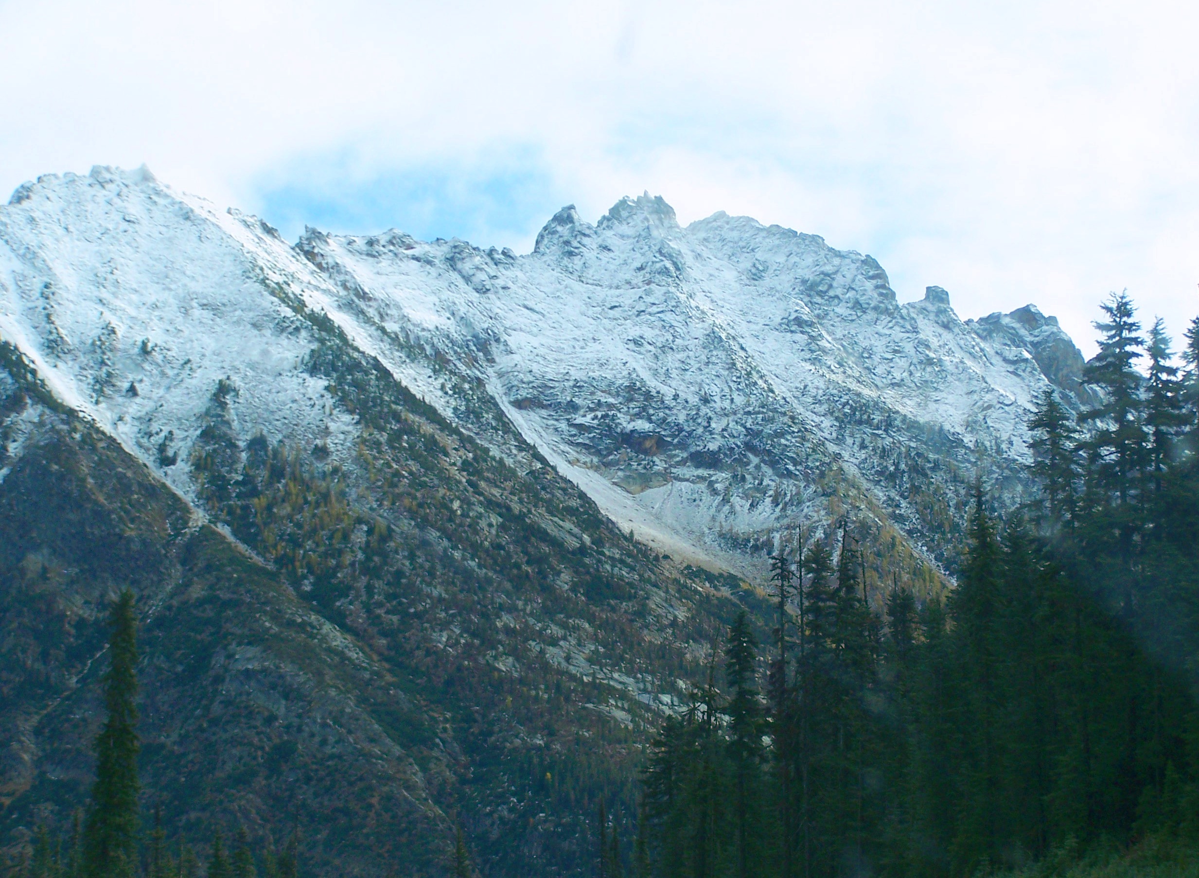
 Rugged, remote peaks of the North Cascades, just east of Washington Pass
It wasn't until 1895, however, that funding to explore a possible route through the Cascade Range was appropriated.
After one year of surveying possible routes in the Upper Skagit River region, the State Road Commission concluded in 1896 that the Skagit gorge was not a practical route. Instead, the commission settled upon the Cascade Pass route, several miles south of the Skagit gorge. The Cascade Pass route began to be roughed out in 1897 and shortly afterward, state highway maps showed the road as either State Highway 1 or the Cascade Wagon Road. In the following years, floods on the Cascade River took out most of the work completed on the road and led Washington's first State Highway Commissioner to report in 1905 that almost all the money appropriated for the road had been wasted. After these unsuccessful attempts to build a northern cross-mountain highway, the state designated that a highway be built along the Methow River from Pateros to Hart's Pass, high above Eastern Washington's Methow Valley. This road was completed in 1909.
By 1936, both of Seattle City Light projects, Gorge Dam and Diablo Dam had been completed and were attracting visitors and families to the area. In 1940, the first stage of the completion of Ross Dam was reached. Because this influx of population and interest in the area once again demonstrated the need for a northern route over the high Cascades, highway promoters began to try and persuade other boosters to finally abandon the idea of the ill-fated Cascade Pass route and instead look to agreeing on a route across Rainy and Washington Pass. In 1953, the North Cascades Highway Association was formed with politicians, lobbyists, and business owners from both sides of the North Cascades taking part. As these boosters pushed Olympia harder to move forward on the highway plan, more and more requests for huge sales of old-growth timber from along the highway corridor came in. These increasing timber requests were used to support the need for a highway.
Finally, in 1958, the State of Washington appropriated funds to build a highway from the Seattle City Light company town of Diablo to Thunder Arm, a southern arm of Diablo Lake. Funds were also allotted to improve access roads on both sides of the North Cascades and construction on this section of the highway began in 1959. Over the next nine years, construction of the road would continue along with the signing of the North Cascades National Park bill by President Lyndon B. Johnson in 1968. With this bill, the hope of using the highway as access for high-dollar timber sales was quashed. Nonetheless, businessmen and residents on both sides of the North Cascades were hopeful and supportive of the tourist dollars that would be seen with the opening of the "North-Cross Highway".
 North Cascades Highway just west of Rainy Pass and the Pacific Crest Trail
Moreoever, the Methow Valley town of Winthrop, Washington was in the process of transforming itself from a sleepy cow-town into a tourist town with a western-style theme, complete with false-front buildings and boardwalk sidewalks. Finally, in mid-1972, the more-than-a-century-old idea of connecting western Washington with eastern Washington by a northern highway route had come to fruition.
Amidst fanfare, music provided by the Concrete High School Band, and ribbon cutting, Highway 20 was officially connected from western to eastern Washington via Washington Pass on 2 September 1972. Then-governor Daniel J. Evans, a host of state dignitaries, and then-President Richard M. Nixon's brother Donald were in attendance for the opening and vehicle procession over the Cascade Mountains.[3]
Route description
 Liberty Bell Mountain from 5477 ft. elevation Washington Pass on North Cascades Highway
SR 20 begins at a wye-junction in Discovery Bay, Washington at U.S. Route 101 and goes north to Port Townsend. Just prior to entering the city, it connects to the northern terminus of SR-19. SR 20 then travels through the modern section Port Townsend to the ferry terminal at the Southern edge of historic downtown Port Townsend. The route then travels via the Port Townsend-Keystone route of the Washington State Ferries to Keystone on Whidbey Island.
Once on Whidbey Island SR 20 travels eastward along former tidal flats between Admiralty Inlet and Crocket Lake to the Northern Terminus of SR-525. The route turns north, supplanting SR 525, and travels through Ebey's Landing National Historical Reserve to the town of Coupeville. While traveling near Coupeville, eastbound lanes are traveling westward, and vice-versa, often causing confusion when directing tourists. The route continues west to Fort Ebey, then travels along the western shore of Penn Cove, through the former town of San De Fuca, before turning northward to Oak Harbor. Once in Oak Harbor, SR-20 follows the route of Pioneer Way to its intersection with Oak Harbor St., at which point SR-20 turns onto Oak Harbor St. After less than one mile, SR-20 veers off of Oak Harbor St. onto its own right of way that it follows out of Oak Harbor. The route again travels in the wrong direction along the northern border with Whidbey Island NAS, in order to avoid the station's runways. The route then enters Deception Pass State Park and travels over Deception Pass and Canoe Pass over the Deception Pass Bridge (and Canoe Pass Bridge), to Fidalgo Island.
The route weaves through the rocky landscape of Fidalgo Island to Sharpes Corner, on the outskirts of Anacortes, where it meets the eastern terminus of SR 20 Spur, a four-lane expressway. SR 20 turns east onto the expressway, traveling though the Swinomish Reservation, over the former tidal flats of the Skagit Valley. It intersects SR 536 of which the route supplanted to this point. SR 20 veers slightly northward along a new portion of expressway, completed in 2009, which it follows to Burlington. As SR 20 follows the city's streets to avoid downtown, it gains its nickname of "The North Cascades Highway". SR 20 follows a former railroad grade to Sedro-Woolley, where it is again routed around the downtown, and is overlaid with SR 9. On the north side of Sedro-Woolley, SR 9 departs the route, and SR 20 begins the slow climb through the Cascade Mountains to Washington Pass, via Concrete and the northern/eastern terminus of SR 530.
SR 20 travels through the cities of Winthrop and Twisp as it travels down the eastern slopes of the Cascade Mountains. Just south of Twisp, SR 20 meets SR 153, before turning eastward to Okanogan. Just south of Okanogan, SR 20 is overlaid with US 97. SR 20 stays with US 97 to the city of Tonasket, where it continues its eastward journey. SR 20 travels through the cities of Republic, Kettle Falls, and Colville before reaching its final destination of Newport as US 2 approximately 1000 ft (330 m) from the Washington/Idaho State Line.
Annual closure
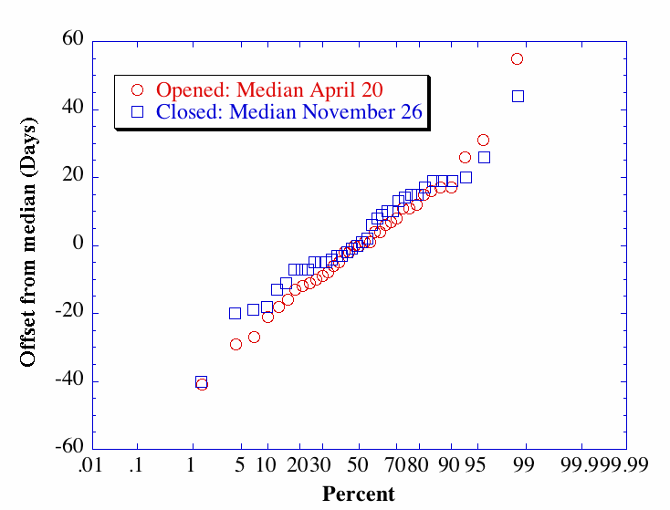
SR 20 is one of only three State Routes in Washington that have portions closed in the winter (the others being Routes 410 and 123). Washington Pass (elevation 5477 ft./1669 m.) and nearby Rainy Pass (elev. 4875 ft./1486 m.) annually receive several feet of snow throughout the winter, and are prone to avalanches leaving over 20 feet (6.1 m) of snow on the road.[citation needed]
As of December 2008[update], the median first open date was 20 April. The median final closure date was 26 November. During the drought of the winter of 1976–1977, the highway was not closed.[4]
Major intersections
County Location Mile[1] Destinations Notes Jefferson County 0.00 US 101 – Quilcene, Olympia, Port Angeles7.79 SR 19 south – Port LudlowPort Townsend 12.57 Port Townsend-Keystone Ferry across Admiralty Inlet Island 16.00  SR 525 south – Mukilteo Ferry
Skagit Anacortes 47.45 
 SR 20 Spur – Anacortes, San Juan Ferry
54.07 Farm to Market Road, Best Road Former SR 237 54.62  SR 536 east – Mount Vernon
No access from SR 20 west to SR 536 east Burlington 59.10  I-5 – Vancouver, BC, Seattle
Interchange Sedro-Woolley 64.37  SR 9 south – Arlington
West end of SR 9 overlap 65.64 SR 9 north – SumasEast end of SR 9 overlap Rockport 97.21  SR 530 west – Darrington, Arlington
105.63 Cascade Road – Marblemount Former PSH 17 Okanogan 179.08 Lost River Road – Mazama Former PSH 16 Twisp 200.93 Second Avenue Former PSH 17 203.48  SR 153 south – Chelan, Wenatchee
229.99 Old 97 – Malott, Brewster Former US 97 south; proposed SR 213 Okanogan 232.20 

 SR 215 north / US 97 Bus. north / SR 20 Bus. east – Okanogan, Omak
West end of US 97 Bus. overlap 232.70 US 97 south – WenatcheeEast end of US 97 Bus. overlap; west end of US 97 overlap Omak 237.76  SR 155 south – Omak, Grand Coulee Dam
238.84
SR 215 south / US 97 Bus. south / SR 20 Bus. west – OmakTonasket 261.34 US 97 north – PentictonEast end of US 97 overlap Ferry Republic 302.03 SR 21 south – Keller, WilburWest end of SR 21 overlap 304.59 SR 21 north – Curlew, Grand ForksEast end of SR 21 overlap 341.43 US 395 north – Laurier, Grand ForksWest end of US 395 overlap Stevens 344.18  SR 25 – Marcus, Northport, Davenport
Colville 354.33 US 395 south – SpokaneEast end of US 395 overlap Pend Oreille 389.66  SR 31 north – Metaline Falls
420.70  SR 211 south – Spokane, Davis Lake, Sacheen Lake
Newport 436.13 US 2 – Sandpoint, SpokaneRelated Routes
SR 20 Spur

State Route 20 Spur
Location: Anacortes, Washington Existed: 1964–present  The western land terminus of SR 20 Spur is the Anacortes Ferry Terminal
State Route 20 Spur (SR 20 Spur, also State Route 20 North) is a 7.78-mile (12.52 km) spur route of State Route 20 in the U.S. state of Washington. The highway travels north from SR 20 to the Anacortes Ferry Terminal, entirely within the city of Anacortes in Skagit County, except the ferry portion, which travels within San Juan County. The roadway was established in 1937 as the western segment of the Anacortes branch of Primary State Highway 1, which became SR 536 in 1964 and renumbered to SR 20 Spur and SR 20 in 1973. In 1994, SR 20 was extended along the San Juan Islands ferry, which serves Lopez Island, Shaw Island, Orcas Island and San Juan Island.
 Map of SR 20 Spur
State Route 20 Spur (SR 20 Spur) begins at an intersection with State Route 20 southeast of Downtown Anacortes at the southern end of Fidalgo Bay in a desnse forest.[5] From the terminus, the roadway travels northwest and later west near the bay to become Commercial Avenue in Downtown Anacortes at a turn when the road goes north. The street travels through Downtown Anacortes before turning west to become 12th Street and later goes southwest along the waterfront as Oakes Avenue to an intersection with Sunset Avenue after passing Anacortes Airport.[1] At Sunset Avenue, SR 20 Spur becomes Ferry Terminal Road and curves north to the Anacortes Ferry Terminal in Ship Harbor.[6][7][8] The roadway after the intersection with SR 20 had a daily average of 23,000 motorists in 2007.[9]
SR 20 Spur was established in 1937 as the Anacortes branch of Primary State Highway 1 (PSH 1 AN), which ran from the Anacortes Ferry Terminal to PSH 1 in Mount Vernon, using the current highway along with State Highway 20 and SR 536. The route intersected Secondary State Highway 1D (SSH 1D, now SR 20) in Anacortes, SSH 1C (former SR 237) in Fredonia and a SSH 1C branch (became PSH 16, now SR 20).[10][11] PSH 1 AN was later renumbered during the 1964 highway renumbering to SR 536, SSH 1D became SR 525 and PSH 16 became SR 20.[12][13] When SR 20 was extended west to Discovery Bay from Fredonia in 1974, SR 536 was shortened and SR 20 Spur was created.[14][15] The roadway ended at the Anacortes Ferry Terminal until 1994, when the route was routed onto the San Juan Islands ferry operated by Washington State Ferries.[16][17]
SR 20 Business
SR 20 Business was a bannered route through Okanagan and Omak that followed the former route of SR 20 and US 97, while SR 20 bypasses the cities along with US 97 along the East Bank of the Columbia River. This route has been replaced with SR 215.
Former Route Number
Prior to the completion of the North Cascades Highway, western portions of SR 20 used many different designations.
SR 113
From 1964 until 1973, SR 20 was designated as SR 113 from Discovery Bay to Coupeville. The route had historically been the Port Townsend branch of Primary State Highway 9 (PSH 9 PT) and a branch of Secondary State Highway 1D (SSH 1D) in 1937, during the creation of the Primary and secondary highways.[10] In 1964, these two highways became SR 113, as part of a new numbering system created by the Washington State Legislature and the Washington State Department of Transportation.[12] When SR 20 was extended west from Fredonia in 1973,[14] SR 113 was decommissioned.[13][18][19] The Port Townsend–Keystone ferry wasn't technically part of SR 20 until 1994, when all of the Washington State Ferries routes were added to the state highway system.[20][21]
 SR 20; and SR 20 Spur were the western segments of SR 536 from 1964 until 1973. This map also details the former numbering of SR 20 south of Sharpes Corner toward Deception Pass and Whidbey Island
SR 525
From Coupeville to Sharpes Corner (just outside of Anacortes), the modern SR 20 was designated SR 525, and prior to 1964 as SSH 1D. When the North Cascades Highway was completed, and the SR 20 designation extended Westward, the SR 525 designation was supplanted to Coupeville.
SR 536
From Mt. Vernon to the Anacortes Ferry Terminal, the modern SR 20 (and SR 20 Spur, west of Sharpes Corner) was designated SR 536, and prior to 1964 as the Anacortes Branch of PSH 1. When the North Cascades Highway was completed, and the SR 20 designation extended Westward, the SR 536 designation was supplanted, and the SR 20 Spur designation created to keep the route to the ferry terminal within the highway system.
References
- ^ a b c d Washington State Department of Transportation, State Highway Log, 2006
- ^ Gulick, Bill. A Traveler's History of Washington. Caxton Press, 1996. ISBN 0-8700-4371-4. p. 333
- ^ WSDOT History of North Cascades Highway
- ^ a b "SR 20 - North Cascades Highway - Opening and Closing History". North Cascades Passes. Washington State Department of Transportation. October 2009. http://www.wsdot.wa.gov/Traffic/Passes/NorthCascades/closurehistory.htm. Retrieved 2009-02-08.
- ^ Washington State Department of Transportation (9 September 2004). "SR 20; Junction SR 20 SP ANACRT". http://www.wsdot.wa.gov/mapsdata/tdo/Interchange/pdfs/SR020/020X047.pdf. Retrieved 20 July 2009.
- ^ Google, Inc. Google Maps – State Route 20 Spur (Map). Cartography by Google, Inc. http://maps.google.com/maps?f=d&source=s_d&saddr=WA-20&daddr=48.506636,-122.678002&hl=en&geocode=FXx_4wIdIo6x-A%3B&mra=mi&mrsp=1,0&sz=18&sll=48.506945,-122.677175&sspn=0.00258,0.004807&ie=UTF8&ll=48.489989,-122.630081&spn=0.082596,0.153809&z=13. Retrieved 2009-06-18.
- ^ G. M. Johnson (2004). Skagit Count: Mount Vernon, Anacortes (Map). City Street Maps (2004 ed.). Rockport inset. ISBN 1-894570-90-1. http://store.maplink.com/map.aspx?nav=MS&cid=10056,10078&pid=522946. Retrieved 2009-06-18.
- ^ "City of Anacortes Address Map, 2009". City of Anacortes. 2009-03-31. http://www.cityofanacortes.org/PublicWorks/GIS/Maps/Address_Map_2009.pdf. Retrieved 2009-06-18.
- ^ Washington State Department of Transportation (2007). "2007 Annual Traffic Report". pp. 100–101. http://www.wsdot.wa.gov/mapsdata/tdo/PDF_and_ZIP_Files/Annual_Traffic_Report_2007.pdf. Retrieved 2009-06-18.
- ^ a b Washington State Legislature (1937). "Chapter 190: Establishment of Primary State Highways; Chapter 207: Classification of Public Highways". Session Laws of the State of Washington. Session Laws of the State of Washington (1937 edition ed.). Olympia, Washington: Washington State Legislature. pp. 933, 994–995. http://books.google.com/books?id=G784AAAAIAAJ&pgis=1. Retrieved 2009-06-18. "A primary state highway to be known as Primary State Highway No. 1, or the Pacific Highway, is hereby established according to description as follows: Beginning at the international boundary line in the vicinity of Blaine in Whatcom county, thence in a southerly direction by the most feasible route by way of Bellingham, thence to the east of Lake Samish, thence in a southerly direction by the most feasible route by way of Mt. Vernon, Everett, Seattle, Tacoma, Olympia, Centralia, Chehalis, Kelso and Vancouver to the Washington-Oregon boundary line on the interstate bridge over the Columbia river; also beginning at Bellingham on Primary State Highway No. 1, as herein described, thence in an easterly direction by the most feasible route to a point in the vicinity of Austin Pass in Whatcom county; also beginning at Bellingham on Primary State Highway No. 1, as herein described, thence in a southerly direction by the most feasible route by way of Blanchard to a junction with Primary State Highway No. 1, as herein described, in the vicinity of Mt. Vernon; also beginning at Mt. Vernon on Primary State Highway No. 1, as herein described, thence in a westerly direction by the most feasible route to Anacortes; also beginning at Everett in the vicinity of Broadway Avenue, thence in a southwesterly direction by the most feasible route to a junction with Primary State Highway No. 1, as herein described, in the vicinity south of Everett; (c) Secondary State Highway No. 1C; beginning at a junction with Primary State Highway No. 1 in the vicinity south of Blanchard, thence in a southerly direction by the most feasible route to a junction with Primary State Highway No. 1 in the vicinity of Whitney; also beginning at Burlington on Primary State Highway No. 1, thence in a westerly direction by the most feasible route to a junction with Secondary State Highway No. 1C, as herein described, in the vicinity north of Whitney; (d) Secondary State Highway No. 1D; beginning at a junction with Primary State Highway No. 1 in the vicinity southeast of Anacortes, thence southerly by the most feasible route by way of Deception Pass to the vicinity of Columbia Beach in the southern portion of Whidby Island."
- ^ Washington State Legislature (1961). "Chapter 13: Public Highways". Session Laws of the State of Washington. Session Laws of the State of Washington (1961 edition ed.). Olympia, Washington: Washington State Legislature. p. 520. http://books.google.com/books?id=Wso4AAAAIAAJ&pgis=1. Retrieved 2009-06-18. "47.16.160 No. 16 Methow Valley highway. (Effective July 1, 1961.) A primary state highway to be known as primary state highway No. 16, or the Methow Valley highway, is hereby established according to description as follows: Beginning in the vicinity of Pateros on primary state highway No. 10, thence in a northerly direction by the most feasible route by way of Twisp to Mazama; also beginning at a point in the vicinity south of Twisp on primary state highway No. 16, thence in an easterly direction by the most feasible route to a junction with primary state highway No. 10 in the vicinity south of Okanogan; also, beginning at a wye connection with primary state highway No. 16, southwest of Okanogan, thence southwesterly to a junction with primary state highway No. 10 in the vicinity of Malott: Provided, That until such times as primary state highway No. 16 from southwest of Okanogan to the vicinity of Malott is actually constructed on the location adopted by the highway commission, no existing county roads shall be maintained or improved by the highway commission as a temporary route of said primary state highway No. 16."
- ^ a b C. G. Prahl (1965-12-01). "Identification of State Highways". Washington State Highway Commission, Department of Highways. http://www.wsdot.wa.gov/NR/rdonlyres/6836215D-E301-43F3-895A-472BD2FDE86A/0/Identification.pdf. Retrieved 2009-06-18.
- ^ a b University of Texas at Austin (1966). Victoria, 1966 (Map). 1:250,000. http://www.lib.utexas.edu/maps/topo/250k/txu-pclmaps-topo-us-victoria-1966.jpg. Retrieved 2009-06-18.
- ^ a b Washington State Legislature (1975). "RCW 47.17.081: State route No. 20 north". http://apps.leg.wa.gov/RCW/default.aspx?cite=47.17.081. Retrieved 2009-06-18.
- ^ Washington State Legislature (1964). "RCW 47.17.080: State route No. 20". http://apps.leg.wa.gov/RCW/default.aspx?cite=47.17.080. Retrieved 2009-06-18.
- ^ Washington State House of Representatives (1994-03-30). "Substitute House Bill 2618; Chapter 209, Laws of 1994". Washington State Legislature. http://apps.leg.wa.gov/documents/billdocs/1993-94/Pdf/Bills/Session%20Law%201994/2618-S.SL.pdf. Retrieved 2009-06-18.
- ^ Washington State Legislature (1994-03-30). "HB 2618 – 1993–94: Adding ferry water routes to the state highway system". http://apps.leg.wa.gov/billinfo/summary.aspx?year=1993&bill=2618. Retrieved 2009-06-18.
- ^ Washington State Department of Transportation (1980). "Annual Traffic Report, 1980". p. 71. http://www.wsdot.wa.gov/mapsdata/tdo/PDF_and_ZIP_Files/1980_ATR.pdf. Retrieved 2009-06-20.
- ^ University of Texas at Austin (1965). Seattle, 1965 (Map). 1:250,000. http://www.lib.utexas.edu/maps/topo/250k/txu-pclmaps-topo-us-seattle-1965.jpg. Retrieved 2009-06-20.
- ^ Washington State House of Representatives (1994-03-30). "Substitute House Bill 2618; Chapter 209, Laws of 1994". Washington State Legislature. http://apps.leg.wa.gov/documents/billdocs/1993-94/Pdf/Bills/Session%20Law%201994/2618-S.SL.pdf. Retrieved 2009-06-20.
- ^ Washington State Legislature (1994-03-30). "HB 2618 – 1993–94: Adding ferry water routes to the state highway system". http://apps.leg.wa.gov/billinfo/summary.aspx?year=1993&bill=2618. Retrieved 2009-06-20.
State highways in Washington related to SR 20  Former or proposed: SR 237
 State highways in Pend Oreille County, Washington
U.S. Route 2 in Washington • Washington State Route 20 • Washington State Route 31 • Idaho State Highway 41 • Washington State Route 211
Categories:- State highways in Washington (state)
- Transportation in Jefferson County, Washington
- Transportation in Island County, Washington
- Transportation in Skagit County, Washington
- Transportation in Whatcom County, Washington
- Transportation in Chelan County, Washington
- Transportation in Okanogan County, Washington
- Transportation in Ferry County, Washington
- Transportation in Stevens County, Washington
- Transportation in Pend Oreille County, Washington
- Scenic highways in Washington (state)


Wikimedia Foundation. 2010.