- Hawkinge
-
For the steamship, see SS Hawkinge.
Coordinates: 51°07′01″N 1°09′50″E / 51.117°N 1.1638°E
Hawkinge 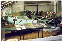
The Kent Battle of Britain Museum in Hawkinge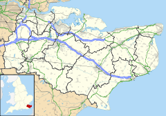
 Hawkinge
Hawkinge shown within KentPopulation 4,405 (parish, 2001 Census) District Shepway Shire county Kent Region South East Country England Sovereign state United Kingdom Dialling code 01303 Police Kent Fire Kent Ambulance South East Coast EU Parliament South East England UK Parliament Folkestone and Hythe List of places: UK • England • Kent Hawkinge (
 /ˈhɔːkɪndʒ/ haw-kinj) is a village and civil parish in the Shepway District of Kent, England. The original village of Hawkinge is actually just less than a mile (c. 1.3 km) due east of the present village centre (roughly 51° 6'55.14"N, 1°11'2.00"E);[1] the modern, much larger, village of Hawkinge was formed by the merging of Hawkinge and Uphill.[2] Walking south from the village past it is possible to see stunning views of Cheriton, Folkestone and the Channel Tunnel complex.
Contents
World War II
During World War II, RAF Hawkinge was the closest operational airfield to France[3] and was used during the Battle of Britain. The airfield is now the site of extensive residential development, which has expanded Hawkinge's population to 9,000. Depending on further building, the population is still expected to grow to 11,000. The construction of the houses was hampered by the discovery of several pipe bombs, put there in the event of a German invasion to render the airfield useless to enemy airplanes. There are several reminders of the war in and near the site of the original village; the Kent Battle of Britain Museum and various pillboxes are scattered amongst the farms.
Governance
The local MP is Damian Collins, having previously been represented by the Rt. Hon. Michael Howard Q.C. (Conservative) since 1983. On Kent County Council, Hawkinge forms part of the Elham Valley Division, represented by Cllr Susan Carey (Conservative). On Shepway District Council Hawkinge is covered by the North Downs East ward, represented by Cllrs David Godfrey, Philip Martin, and Stuart Peall (all Conservative). Hawkinge Parish Council consists of nine elected members; Four Conservatives and five Independents.[4]
Transport
The A260 road which runs from Folkestone to Barham, where it meets with the A2 to Canterbury originally ran through the centre of the village, before it was replaced with a new bypass opened by Michael Howard on Monday 9 July 2007. The southern section, built in the early 2000s, leads from the A20 to a roundabout where it meets with the northern section. This new section carries traffic around the village centre onto the existing road.
 Michael Howard opening the Hawkinge bypass
There is a regular bus service that connects the village to either Folkestone or Canterbury. These are normally run by Stagecoach and have route numbers 16, 16A & 73 (Easy Access Bus).
Shops and services
There are two local churches. The Anglican parish church is St Luke's, the ancient parish church of St Michael's having been declared redundant in 1980;[5] The Baptist Church, having sold its small building, meets in a modern chapel on the first floor of Hawkinge Community Centre.[6] There are three primary schools: Hawkinge Primary School in the old village;[7] The Churchill Primary School;[8] and Selsted Church of England Primary School[9]
The village publishes its own online newspaper, the Hawkinge Gazette and Channel Coast News[10]
Hawkinge has a Tesco Express, a Lidl store and pubs called The Mayfly; The White Horse; The Cat and Custard Pot[11] and the Black Horse. It also has a branch of Natwest bank as well as a doctor's surgery, a chemist and dental surgery. There is an Indian takeaway, a Chinese takeaway which was voted 'Best Take-away Cuisine of 2010' by Shepway council, and an exotic kebab/fish and chip shop which cooks frozen chips purchased from the nearby Lidl. There is also a Hairdressers called Lloyd Admas.
References
- ^ Historical notes on Hawkinge
- ^ Unofficial Hawkinge Website
- ^ KENT BATTLE OF BRITAIN MUSEUM About Former RAF Station Hawkinge
- ^ Hawkinge Parish Council
- ^ Hawkinge old church
- ^ Hawkinge Baptist Church
- ^ Hawkinge Primary School
- ^ The Churchill Primary School
- ^ Selsted Church of England Primary School
- ^ Hawkinge Gazette and Channel Coast News
- ^ 'The Cat and Custard Pot'
External links
 Media related to Hawkinge at Wikimedia Commons
Towns and villages in the Shepway district of Kent, England  Acrise · Arpinge · Beachborough · Bladbean · Bodsham · Breach · Brenzett · Brookland · Burmarsh · Cheriton · Danton Pinch · Densole · Dymchurch · Dungeness · Elham · Elmsted · Etchinghill · Folkestone · Frogholt · Greatstone-on-Sea · Hawkinge · Hythe · Ivychurch · Lade · Littlestone-on-Sea · Lydd · Lydd-on-Sea · Lyminge · Lympne · Monks Horton · Newchurch · Newingreen · Newington · New Romney · Old Romney · Paddlesworth · Pedlinge · Peene · Postling · Rhodes Minnis · Saltwood · Sandgate · Sandling · Sellindge · Selsted · Snargate · Stanford · Stelling Minnis · St Mary in the Marsh · St Mary's Bay · Westenhanger · West Hythe · WingmoreCategories:
- Villages in Kent
- Civil parishes in Kent


Wikimedia Foundation. 2010.