- Wateringen
Dutch town locator maps
mun_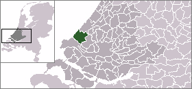
town_
caption = The village (dark green) and the statistical district (light green) of Wateringen in the municipality of Westland.Wateringen is a town in the Dutch province of
South Holland . It is a part of the municipality of Westland, and lies about 5 km southwest ofThe Hague .Until 2004 it was a separate municipality and covered an area of 8.93 km².
The former municipality of Wateringen also included the town
Kwintsheul .The village of "Wateringen" has a population of around 10,860.Statistics Netherlands (CBS), [http://statline.cbs.nl/ "Statline: Kerncijfers wijken en buurten 2003-2005"] . As of
January 1 ,2005 .] The statistical area "Wateringen", which also can include the surrounding countryside, has a population of around 13,880.Statistics Netherlands (CBS), [http://statline.cbs.nl/ "Statline: Kerncijfers wijken en buurten 2003-2005"] . As ofJanuary 1 ,2005 .]Websites
* [http://wateringen.prikstad.nl/ Wateringen online]
References
Wikimedia Foundation. 2010.