- Clock House railway station
-
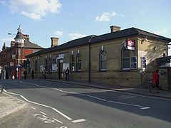
Clock House 
Entrance to Clock House station
 Clock House
Location of Clock House in Greater LondonLocation Beckenham Local authority London Borough of Bromley Managed by Southeastern Station code CLK Number of platforms 2 Fare zone 4 Interchange Kent House [1] National Rail annual entry and exit 2004-05  0.840 million[2]
2005-06 0.868 million[2]2006-07 1.129 million[2]2007-08 1.196 million[2]2008-09  1.133 million[2]
1 May 1890 Opened List of stations Underground · National Rail External links Departures • Layout Facilities • Buses Coordinates: 51°24′31″N 0°02′28″W / 51.4085°N 0.0410°W
 A 1908 Railway Clearing House map of part of the Hayes Line, between Lower Sydenham and Elmers End, showing the now closed Addiscombe Line and W&SCR branches off the Hayes Line.
Clock House railway station is in the London Borough of Bromley in south east London, in Travelcard Zone 4 between Beckenham and Penge. The station and all trains serving it are operated by Southeastern on the Hayes line.
The station, which was opened by the South Eastern Railway in 1890, is named after the nearby residence of the Cator Family, demolished in 1896.Clock House retains its original street level booking hall and the remannts of its platform canopies and was formerly known for its tendency to flood whenever overwhelmed by the Chaffinch brook.[3] The station name can be spelt either Clock House or Clockhouse. For example, the previous station signage used the latter (historically inaccurate) form, whilst the published timetables use the former version. The new Southeastern re-branded station signage and livery has since corrected this inaccuracy.
Contents
Services
The typical off peak service is:
- 2tph (trains per hour) northbound, calling at all stations to Cannon Street
- 2tph northbound calling at all stations to Ladywell then fast to London Bridge, Waterloo East and Charing Cross
- 4tph southbound calling at all stations to Hayes
Preceding station  National Rail
Following station New Beckenham Southeastern
Hayes LineElmers End Interchange
The station is a short walk from the Beckenham Road stop on the Tramlink light rail system, which is situated at a higher level on the opposite side of Beckenham Road. Bus stops on roads adjacent to the station provide interchange with the following bus services (as of January 2008):[4]
- 194 – Sydenham – Croydon;
- 227 – Bromley – Crystal Palace;
- 354 – Bromley – Penge;
- 358 – Orpington – Crystal Palace;
Accessibility
Platform Two (trains towards Hayes) has step-free access, but Platform One (trains towards London) is steps-only.
Layout
Side Platform Platform 1 Southeastern towards Charing Cross, Cannon Street Southeastern towards Hayes Side Platform Platform 2 References
- ^ "Out of Station Interchanges" (Microsoft Excel). Transport for London. May 2011. http://www.whatdotheyknow.com/request/67647/response/172834/attach/3/OSI%20Report%20May2011FR%20V2%2017012011.xls. Retrieved 7 August 2011.
- ^ a b c d e "Station usage". Rail statistics. Office of Rail Regulation. 30 April 2010. http://www.rail-reg.gov.uk/server/show/nav.1529. Retrieved 17 January 2011. Please note: Some methodology may vary year on year.
- ^ "The Railways of Beckenham", Andrew Hajducki, 2011[page needed]
- ^ "Buses and trams from Beckenham Road". Transport for London. http://www.tfl.gov.uk/tfl/gettingaround/maps/buses/pdf/beckenhamroad-11313.pdf. Retrieved 2007-01-30.
External links
- Train times and station information for Clock House railway station from National Rail
- Beckenham History
Categories:- Rail transport stations in London fare zone 4
- Railway stations in Bromley
- Former South Eastern Railway (UK) stations
- Railway stations opened in 1890
- Railway stations served by Southeastern
- DfT Category D stations


Wikimedia Foundation. 2010.