- Cricklewood railway station
-
Cricklewood 
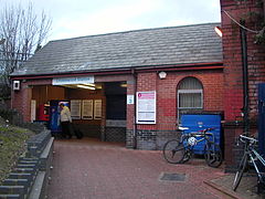
Exterior of main station building at Cricklewood
 Cricklewood
Location of Cricklewood in Greater LondonLocation Cricklewood Local authority London Borough of Barnet Managed by First Capital Connect Station code CRI Number of platforms 4 Fare zone 3 National Rail annual entry and exit 2004-05  0.421 million[1]
2005-06 0.432 million[1]2006-07 1.542 million[1]2007-08  1.327 million[1]
2008-09 1.042 million[1]1868 Opened List of stations Underground · National Rail External links Departures • Layout Facilities • Buses Coordinates: 51°33′31″N 0°12′46″W / 51.5586°N 0.2129°W
Cricklewood railway station is in the London Borough of Barnet in North London. The station lies on the north-south Midland Main Line where it crosses Cricklewood Lane. It is served by First Capital Connect services as part of the Thameslink service. It is in London Travelcard Zone 3.
Contents
History
 Local train at Cricklewood in 1948
It was built as Childs Hill and Cricklewood by the Midland Railway in 1868 when it built its extension (now called the Midland Main Line) to St. Pancras and the station acquired its present name in 1903.
To the north of the station, a motive power depot was built with a large roundhouse in 1882, with a second in 1893. With this was built a large marshalling yard and, in later years, LMS Garratts would be seen with their massive trains of coal from Toton in the Nottinghamshire and Derbyshire coalfields.[2]
 Up stopping train in 1950
A loop line, no longer in existence, was built heading north on the western side of the railway yard, then turning east underneath the main line at the viaduct over the River Brent (and also now the North Circular Road), then south on the eastern side. This obviously allowed trains to reverse direction, but also conveniently joined the railway yards on the two sides of the main lines.
Between 1899 and 1926, a number of proposals were put forward to build an underground railway along the Edgware Road from Central London to Cricklewood via Kilburn, and envisaged the construction of a Tube station at Cricklewood. None of the schemes succeeded and the line was never built.[3]
Services
First Capital Connect run services on the Thameslink route. The typical off-peak service is four trains per hour southbound to London, Wimbledon and Sutton, and four trains per hour northbound, of which two terminate at St Albans and two at Luton. First Capital Connect services to Bedford, Gatwick Airport and Brighton run through with out stopping.
East Midlands Trains InterCity services from Sheffield, Nottingham and Leicester run through at high speed on the Midland Main Line, but do not stop. Interchange with these services can be made at Luton and St Pancras International.
Development
 Northbound view from Platform 1 of the four platforms. Two additional freight tracks are on the extreme left
A new Brent Cross Thameslink station is proposed further north, and the four platforms at Cricklewood station are not being extended from 8 to 12 carriages. This is due to a possible station at Brent Cross, further north on the line. The only other Thameslink stations north of the River Thames remaining with 8-car platform lengths are Hendon and Kentish Town. The developers of Brent Cross Thameslink are also planning to upgrade Cricklewood station by providing funding to have step free access to all platforms.[4]
From March 2009, Southeastern and First Capital Connect began running some peak hour trains from Sevenoaks to Luton,[5] though in the off-peak these services turn back at Kentish Town.
Other trains from south of the River Thames within the larger Thameslink network may call at the station from 2015, when it is likely that the existing Sutton Loop trains will terminate at Blackfriars.[6]
The Office of Rail Regulation has told Network Rail the procedure (using the Railways Act 1993) to close Cricklewood station, if a new one further north is opened.[7]
In early 2008, the London Group of the Campaign for Better Transport published a proposal[8] for an off-road, mainly orbital North and West London Light railway (NWLLR), sharing the orbital Dudding Hill Line freight corridor, and taking over at least one of the two Midland Railway freight lines which run through Cricklewood station. If the scheme were to go ahead, it would provide one or maybe two extra light-rail platforms at the station.
Transport links
London bus routes 189, 226, 245, 260, 460, C11 pass the station, route 16, 32, 266, 316, 332, school routes 632 and night route N16 8mins walk to the station.
Service pattern
Preceding station  National Rail
Following station Hendon First Capital Connect
ThameslinkWest Hampstead
ThameslinkFirst Capital Connect
Bedford-SevenoaksDisused railways Welsh Harp
Line open, station closedMidland Railway
Midland Main LineWest Hampstead
Line and station openDudding Hill
Line open (freight only), station closedMidland Railway
Dudding Hill LineReferences
- ^ a b c d e "Station usage". Rail statistics. Office of Rail Regulation. 30 April 2010. http://www.rail-reg.gov.uk/server/show/nav.1529. Retrieved 17 January 2011. Please note: Some methodology may vary year on year.
- ^ Radford, B., (1983) Midland Line Memories: a Pictorial History of the Midland Railway Main Line Between London (St Pancras) & Derby London: Bloomsbury Books
- ^ Badsey-Ellis, Antony (2005). London's Lost Tube Schemes. Capital Transport. ISBN 1-85414-293-3.
- ^ Brent Cross Cricklewood: The benefits Accessed 20 December 2010
- ^ Train Times - Thameslink Route. First Capital Connect. March–May 2009. p. 52. http://www.firstcapitalconnect.co.uk/content/doc/timetables/tttl_book_pdf_ontime_final_ver.pdf. Retrieved 2009-03-16.
- ^ "Thameslink Programme - FAQ". http://www.thameslinkprogramme.co.uk/faqs/faqs_categories/public_index#question_42. Retrieved 21 November 2008.
- ^ Sale of railway land, and possible station closure.
- ^ London Campaign for Better Transport North and West London light railway (NWLLR) / Brent Cross Railway (BCR) plan
- Butt, R. V. J. (1995). The Directory of Railway Stations: details every public and private passenger station, halt, platform and stopping place, past and present (1st ed.). Sparkford: Patrick Stephens Ltd. ISBN 1-8526-0508-1. OCLC 60251199.
Categories:- Rail transport stations in London fare zone 3
- Railway stations in Barnet
- Former Midland Railway stations
- Railway stations opened in 1868
- Railway stations served by First Capital Connect
- DfT Category E stations


Wikimedia Foundation. 2010.