- Sarda River
-
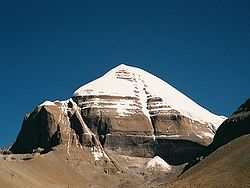 Kailash mountains- Source of Mahakali and Karnali rivers
Sarda River forms part of the border between the nations of India and Nepal. It is called the Mahakali River in Nepal and Kali Gad by local pahari people . This boundary was established by the 1816 Sugauli treaty, but a portion of this border near China has been in dispute.[1] After leaving the border, the river flows southeast across the Ganges basin until it merges into the Ghaghara River, an affluent of the Ganges. India has proposed building a dam across the Sarda in Nepalese territory, but this plan has proven controversial.[2]
Contents
Course
The Sarda originates from the Greater Himalayas at Kalapaani (there is a long lingering dispute over territory with Nepal) at an altitude of 3600 m, in the Pithoragarh District of Uttarakhand, India, joins with the Gori Ganga at Jauljibi, which in turn joins the Saryu River at Pancheshwar. (The area around Pancheshwar is called 'Kali Kumaon'). Kalapaani is situated on the route of Kailash Manasarovar Yatra(Pilgrimage) tour and it is said that it was here that the Great Sage Vyasa meditated and spent his life, thus, giving the valley its name, the Vyasa valley. The river is named after the Goddess Kali whose temple is situated in Kalapaani near the Lipu-Lekh pass at the border between India and Tibet (China).
The river borders the Nepalese Mahakali Zone and the Indian state of Uttarakhand. It was the site of the Nepalese military base prior to the Gurkha War (Anglo-Nepal War of 1814-16). The Sugauli Treaty signed by Nepal and British India in 1816 after the end of the war, locates the Mahakali River as Nepal's western boundary with India. The river flows in a gorge section in the upper region. The Mahakali after it descends into the plains into India is known as Sarda, which meets the Ghaghara (Karnali in Nepal) in Indian Territory at about 323.5 km[3][4] from the existing Upper Sarda Barrage at Banbasa.
Mahakali flows for a length of 223 km length in Nepal and 323.5 km in India up to its confluence with Ghaghra river.[3][5][6]
River Basin Characteristics
Mahakali (Sarda in India) is one of the five major river basins of Nepal which is shared with India and has a total basin area of 14871 km[7] up to Upper Sarda Barrage, about 34 per cent of which lies in Nepal. The total catchment area is 17,818 km[7] up to Lower Sarda Barrage.[3]
In Nepal, It lies entirely in the Far Western Region of Nepal and in the Mahakali Zone which has four administrative districts - Baitadi District with Baitadi as its headquarters, Dadeldhura District with Dadeldhura as its headquarters, Darchula District with Darchula as its headquarters and Kanchanpur District with Mahendranagar as its headquarters.
Kumaon of Champawat district and part of Udham Singh Nagar district fall under the Sarda basin. No large tributary joins the Sarda between Upper Sarda and Lower Sarda barrages in India. In Uttar Pradesh, part of Lakhimpur Kheri district is also under the Sarda basin.
Important towns and Villages
The Important towns and villages beside which it flows are Amargadhi, Chandani, Dodhara, Darchula Bazar, Dasrathchand and Mahendranagar [disambiguation needed
 ] in Nepal. Balwakote, Banbasa, Champawat, Jauljibi, Lohaghat, Titri, Handeshar, Jhulaghat, Munsiyari, Pancheshwar, Tanakpur, etc., in India lie to the west of Mahakali river.
National Parks in the basin
Notable national parks are Sukla Phanta Wildlife Reserve in Nepal and Dudhwa National Park on the Indo-Nepal border in India.
a) Shuklaphanta Wildlife Reserve in Nepal has evolved over the years from a Hunting Reserve In 1969, to the gazetted Shukla Phanta Wildlife Reserve in July 1976 with .an area of 155 km[7] to protect Nepal's last remaining herd of swamp deer (Cervus duvaucalli). Now it stands extended to the current size of 305 km.[7] It is bounded Kanchanpur District in the extreme south-western section, has a common boundary with the Indian state of Uttar Pradesh in the south and west which is formed by the Mahakali (Sarda), River, and is bordered on the east by the Chaudhar River and in the north by a forest belt and cultivations. The reserve supports a wide range of biodiversity, which is nationally and globally important. Primarily the vegetation types are Sal forest, Sal savanna, which is part of continuum between climax forest and grassland that is maintained by fire and floods. The reserve supports the largest population of Bengal florican Houbaropsis bengalensis (E) and swamp deer Cervus duvauceli (E). It is also home to 14 species of Fish. 350 species of birds and 24 species of Mammal.[8]
b) Dudhwa National Park is located at India-Nepal border, in Uttar Pradesh in India. The northern edge of the Park lies along the Indo-Nepal border, and the southern boundary is formed by the Suheli River. The terrain of the Park varies from mosaic grasslands, dense sal forests and swampy marshes. It has diverse wildlife population. Another reserve area "Kishunpur Pashu Vihar" sanctuary located about 30 km from Dudhwa. spread over about 204 sqr.km, lies on the banks of river Sharda and is surrounded by Sal forest of adjoining reserve forests. In 1987 Dudhwa National Park and Kishunpur Pashu Vihar were merged to form the Dudhwa Tiger Reserve (DTR). Although the Tigers at the Park are numerous, sightings are rare due to the thick forest cover of the area. Besides Tigers, Leopards, Hispid Hares, Swamp Deer (Barasingha) and Rhinos thrive amidst the vegetation, it is home to 400 species of resident and migratory birds, 37 species of mammals and 16 species of reptiles Main Wildlife found are Swamp Deer, Chital, Hog Deer, Sambar, Rhino.[9]
Water Rafting in Kumaon Region
As the river flows down from the Nepal border through Kumaon hills and as the Kali and Gori Rivers meet at Jauljibi, with increased water volume, it offers great river rafting adventure to professionals, for a length of 117 km, from Jauljibi to Tanakpur. In rafting parlance, in this stretch, the rapids in the river are of Grade IV and more, which could be covered in 3 days. Below Tanakpur, Lower down among the frosted slopes, the river becomes calmer offering the amateur a sporting challenge.
Places of Religious interest
In the Kumaon region in India every peak, lake or mountain range is somehow or the other connected with some myth or the name of a God or Goddess, ranging from those associated with the Shaiva, Shakta and Vaishnava traditions, to local Gods like Ham, Saim, Golla, Chhurmal, Kail Bisht, Bholanath, Gangnath, Airy and Chaumu. Referring to the rich religious myths and lores associated with Uttaranchal, E.T.Atkinson has said: 'To the beliefs of the great majority of Hindus, the Kumaon (Himalaya) is what Palestine is to the Christian.'[10]
In Kumaon, Famous temples are the Kali temple at Kalapani, Shiva temple of Singhphal in Dudhwa reserve, the Baleshwar temple (in South Indian architectural style) at Champawat[3], an Indian National Heritage Monument of Archaeological Survey of India (ASI) since 1952, and Nagnath temple in Champawat
Development Scenario
Sources:[3][4][5][6][7][11][12][13]
Mahakali Treaty
The Treaty on Integrated Development of Mahakali River was signed by the Prime Minister of His Majesty's Government of Nepal and the Prime Minister of the Government of India in February 1996 and which came into effect in June 1997. It concerns with the Integrated Development of the Mahakali (Sarda in India) River including Sarda Barrage (existing), Tanakpur Barrage (existing) and Pancheshwar Project (Proposed – under Planning). Pancheshwar Multipurpose Project (PMP) on the river Mahakali is the centerpiece of the Treaty.
The Treaty has 12 Articles with a preamble. As per the Treaty principles both sides are committed to design and operate the project as a single, integrated scheme to yield, “the maximum total net benefits accruing to them”. The power benefit is to be assessed on the basis of saving in costs as compared with the relevant alternatives available. As per the Treaty “equal entitlement in the utilization of the waters of the Mahakali River “without prejudice to their respective existing consumptive uses” is also planned to be ensured from the PMP.
The concluding Article 12 states as under:
- Following the conclusion of this Treaty, the earlier understandings reached between the parties concerning the utilization of the waters of the Mahakali River from the Sarada Barrage and the Tanakpur Barrage, which have been incorporated herein, shall be deemed to have been replaced by this Treaty.
- This Treaty shall be subject to ratification and shall enter into force on the date of exchange of instruments of ratification. It shall remain valid for a period of seventy-five (75) years from the date of its entry into force.
- This Treaty shall be reviewed by both the parties at ten (10) years interval or earlier as required by either party and make amendments thereto, if necessary.
- Agreements, as required, shall be entered into by the parties to give effect to the provisions of this Treaty.
As per a submission by the DDP Secretariat of the United Nations Environment Programme (UNEP) on Dams and Development Project,[14] on the Mahakali Treaty it is stated that "the Treaty emphasizes an integrated approach to the development of water resources and, more importantly, attempts to validate past activities taken to develop water resources on the Mahakali River." UNEP has in conclusion observed that "the signing of the Mahakali Treaty has indeed provided India and Nepal with an opportunity for meaningful cooperation to benefit the millions of people in the two countries whose livelihood depends on the waters of the Mahakali River."
Some details of the projects referred in the Treaty are elaborated below.
Irrigation
Sarda Barrage (Upper Sarda Barrage) Irrigation Project
The Sarda Barrage on the Sarda River (Mahakali River), the first irrigation project on the river, was built in the 1920s under an Agreement signed between British India and Nepal (Sarda Agreement Letters of Exchange dated 23 August 1920 and 12 October 1920) to exchange 4000 acres (for a compensation of Rs 50,000 to Nepal) of the eastern flank of West Nepal.[15] It still regulates the diversion of the (Sarda) Mahakali River exclusively for the purpose of irrigation and power in Uttar Pradesh in India. Before 1920 the Mahakali was a border river with the left bank in Nepal and the right bank in India. The Sarda Agreement of 1920-transferred ownership of part of the left bank area (in the vicinity of the Barrage) from Nepal to India and the Sarda Barrage belongs to India. This agreement has been subsumed in the Mahakali Treaty signed in February 1996 (referred above) and ratified on 27 November 1996. which entails the following supply from the Sarda Barrage to Nepal.
Although the Sarda Agreement was made in 1920, Nepal could utilize her share of the water only after the construction of the Mahakali Irrigation Project in 1975.
Water is diverted from the Barrage to the Sarda Right Bank Canal, (with a capacity of about 396 m³/s) (2), for irrigation in India. In addition to the irrigation facilities, India also generates hydropower with an installed capacity of 41 MW from the canal head power station.
Lower Sarda Barrage
The Lower Sarda Barrage[4][5] is located on the Sarda River in India, about 163.5 km downstream of the Upper Sarda Barrage, to provide protective irrigation to a cultivable area of 2 m ha. The site is located about 25 km from the Lakhimpur-Kheri town. This project is part of the Sarda Sahayak Pariyojana (Project) and primarily depends on water diverted from the Karnali (Ghaghra) at Girjapur through the Sarda Sahayak link canal of 28.4 km length for over eight months in the year during the lean season. But it indents on Sarda supplies during the monsoon between July and October when the Karnali carries a lot of silt. From a 258.8 km long feeder channel from the Barrage, supplies are fed into the different branches of the Sarda canal system, namely, the Daryabad branch, the Barabanki branch, the Haidergarh branch, the Rae Bareli branch and the Purva branch. The project was commissioned in 1974.
Hydropower
In Nepal, Karnali and Mahakali rivers together have hydropower potential of 36,180 MW (economically exploitable is 25,000 MW) out of a total potential of 83,000 MW.
In the Indian state of Uttaranchal, which adjoins the Sarda (Mahakali river), the power generation envisaged is likely to be 6400 MW at 60% load factor (about 24,000 MW at 16% load factor) out of which 2400 MW (9000 MW at 16% load factor) is from the right bank tributaries of the Sarda (Mahakali), excluding the Pancheswar Multipurpose Project.
Some of the projects built/under construction/planned are as under.
Tanakpur Barrage and Hydroelectric Project
Tanakpur HEP is a run of the river scheme on the Sarda River (Mahakali River in Nepal) located near the town of Tanakpur in the district of Champawat. It has a Barrage across the Sarda River for diverting river flows into a 6.2 km long power channel of 566 m³/s capacity for utilization of 24 m head available between the Barrage at Tanakpur and the existing Sarda canal i.e. 0.6 km down stream of Banbassa Barrage. The power station with 3 units of 40 MW (3x40 MW=120 MW) is located near the existing Banbasa Barrage. The tail race channel joins directly the Sarda River. The project is designed to produce 460 million units of power on 90% availability. The construction of the Barrage was started in 1988.[6][16] In the spirit of furthering cooperation within the Mahakali River area, the Governments of India and Nepal entered into a Memorandum of Understanding (MOU), commonly referred to as the Tanakpur Agreement, on December 6, 1991. The Agreement provided for the construction of the left afflux bund (the retaining wall) on Nepalese territory for which the Nepalese provided 2.9 hectares of land to construct the left afflux bund of 577 m length. As a quid pro quo, the Agreement provided for the installation of a head regulator (main part of the reservoir regulating the water flow) at the Tanakpur Barrage with a capacity of 1,000 cu ft/s (28 m3/s), and required India to construct a canal so that 150 cu ft/s (4.2 m3/s) of water could be delivered to Nepal. India was also required to provide 10 million kWh of power to Nepal with, free of charge.
The Tanakpur Project was commissioned in April 1993. But the seething discontent entrenched for nearly five years in Nepal on benefits agreed to be provided by India to Nepal under the agreement of 1991 continued till the Mahakali Treaty between the two countries for the integrated development of water resources on the Mahakali River was signed on February 12, 1996. The Mahakali Treaty has subsumed the regime established by the Sarda Treaty, has validated the controversial Tanakpur Agreement, and endorsed the idea of a new multipurpose project – The Pancheswar Multipurpose Project (PMP) - the details of which, are being worked out. As per the Treaty, Nepal is now entitled to an annual supply of 70 million kWh of power from Tanakpur HEP on a continuous basis, free of cost, from the effective date of the Mahakali Treaty. For this purpose, India also agreed to construct a 132 kV transmission line all the way to the Indo-Nepalese border from the Tanakpur Power Station. There is provision for the supply of 350 cu ft/s (9.9 m3/s) of water for the irrigation of Dodhara Chandni area. India has also agreed to construct a road linking Tanakpur to Nepal's East-West highway.
Pancheshwar Multipurpose Project (PMP) & Poornagiri Re-regulating Dam (Indo – Nepal)
In compliance of the Treaty provisions mentioned above, the scope of Pancheshwar Multipurpose Project (PMP)[17] is being actively discussed and defined by Nepal and India to enable finalisation of the Detailed Project Report. The proposed project, which straddles the border that lies along the median point of the river, envisages a 293 m high rock fill dam (to be the largest rock fill dam in the world), just downstream of the confluence of the Mahakali and Sarju river, having a live storage capacity of 9.24 BCM and a dead storage capacity of 2.15 BCM. In the project area, the river forms the border between India and Nepal, dividing the Far Western Development Region of Nepal from the Uttar Pradesh State in India. The PMP also envisages a re-regulating dam for which two alternatives at Poornagiri (1020 MW) and Rupaligad (500 MW) have been considered, to hold the waters passing through the turbines and provide regulated back season release to irrigate designated commands in Nepal and India. Two power stations are projected, one on either bank, with an overall installed peaking capacity, between 5,500 and 6,480 MW at 20 per cent load factor. As per the Treaty principles both sides are committed to design and operate the project as a single, integrated scheme to yield, “the maximum total net benefits accruing to them”. The power benefit is to be assessed on the basis of saving in costs as compared with the relevant alternatives available. As per the Treaty “equal entitlement in the utilization of the waters of the Mahakali River “without prejudice to their respective existing consumptive uses” is also planned to be ensured from the PMP.
Chameliya Hydroelectric Project
Chameliya Hydroelectric Project, in Nepal (in the Far Western Development Region), a daily peaking run-off-river (PROR) scheme with an installed capacity of 30 MW, has been taken up for construction during January 2007. The Project lies about 950 km west of Kathmandu on Chameliya river, a tributary of Mahakali river in Darchula district. The Main features of the Project are 54 m high concrete dam, 4.06 km long headrace tunnel, surge tank, penstocks and semi- underground powerhouse with two units of each 15.3 MW vertical shaft Francis turbines. The generated power from the Project will be evacuated through 131 km long 132 kV transmission line.[4] connecting Attariya Substation at Kailali district.
See also
References
- ^ Staff (May 15, 1998). "India's Boundary Disputes with China, Nepal, and Pakistan". International Boundary Consultants. http://www.boundaries.com/India.htm. Retrieved 2007-11-16.
- ^ Singh, Jyotsna (August 19, 2003). "India's river plans spark furore". BBC News. http://news.bbc.co.uk/1/hi/world/south_asia/3151809.stm. Retrieved 2007-11-16.
- ^ a b c d India’s Water Wealth, Dr. K.L.Rao, Published by Orient Longmann Ltd, New Delhi 110002.
- ^ a b c Indo-Nepal Water Resource Negotiation: Deepening Divide over Border Project - Rakesh Tiwary, South Asia Journal, January - March 2006.
- ^ a b c Design and Construction of selected Barrages in India (1981), Publication number 149, Central Board of Irrigation and Power, Malcha Marg, Chanakyapuri, New Delhi.
- ^ a b c Barrages in India (1981), Publication number 148, Central Board of Irrigation and Power, Malcha Marg, Chanakyapuri, New Delhi
- ^ a b c d e World Bank (1987), Nepal and International Inland Waterways issues, Legal Department, Asian Division: World Bank.
- ^ "Home". Save The Tiger Fund. 2002-07-22. http://www.savethetigerfund.org/AM/Template.cfm. Retrieved 2010-08-25.
- ^ Dudhwa National Park, Kheri
- ^ "FREE Website Creator and low cost hosting, DIY Online Easy Web Builder". Uttarakhand.esiti.net. http://www.uttarakhand.esiti.net/page/21278/ua.htm. Retrieved 2010-08-25.
- ^ World Bank (1980), Staff Appraisal Report, Mahakali Irrigation Project Stage I, South Asia Projects Department: World Bank.
- ^ Water Conflicts in South Asia, Managing Water Resources Disputes within and Between Countries of the Region (2004), Published by GEE-21Honolulu Hi 96825-0517,USA.
- ^ B.G. Verghese, Water of Hope: From Vision to Reality in the Himalaya- Ganga Development Cooperation, New Delhi: Oxford & IBH Publishing CO.Pvt. Limited, [1999].
- ^ http://72.14.235.104/search?q=cache:x_vf-dTxPxgJ:hqweb.unep.org/dams/documents/ell.asp%3Fstory_id%3D123+Mahakali+Treaty&hl=en&ct=clnk&cd=10
- ^ [1][dead link]
- ^ [2]
- ^ "Central Water Commission - An apex organization in water resources development in India". Cwc.nic.in. http://cwc.nic.in/main/webpages/dr/activities.html. Retrieved 2010-08-25.
Coordinates: 27°21′N 81°23′E / 27.35°N 81.383°E
Hydrology of Uttarakhand Rivers Lakes Dams/ Barrages Asan Barrage • Bhali Dam • Bhimgoda Barrage • Dakpathar Barrage • Ichari Dam • Koteshwar Dam • Maneri Dam • Pashulok Barrage • Ramganga Dam • Tehri DamGlaciers Gangotri • Kafni • Kalabaland • Meola • Milam • Namik • Panchchuli • Pindari • Ralam • Satopanth • SonaRelated topics GomukhHydrology of Nepal Rivers Mahananda basinSapta Koshi basinArun or Bum-chu • Barun • Bhote Koshi or Rongshar Tsangpo • Dudh Kosi • Hongu • Imja Khola • Indravati • Kosi or Sapta Koshi • Sabha • Sangkhuwa • Siswa • Sun Kosi or Matsang Tsangpo • TamurBagmati basinBagmati • Bisnumati • Kamala • LakhandeiNarayani basinKarnali basinBheri • Karnali or Ghagra • Kalapani • Kali • Panjang • Rohini • Sarda or Mahakali • Seti • Thuli Bheri • West Rapti RiverLakes Glaciers Icefalls Related topics Categories:- Rivers of India
- Rivers of Nepal
- International rivers of Asia
- Rivers of Uttarakhand
- India–Nepal border

Wikimedia Foundation. 2010.