- Cluj-Napoca metropolitan area
-
Cluj-Napoca metropolitan area — Metropolitan area — 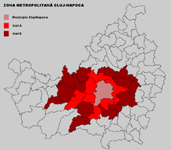
Coordinates: 46°46′N 23°35′E / 46.767°N 23.583°ECoordinates: 46°46′N 23°35′E / 46.767°N 23.583°E Country  Romania
County  Cluj
ClujCentral Municipality Cluj-Napoca Other localities Apahida, Feleacu, Ciurila, Floreşti, Gilău, Baciu and Chinteni Functional 2008 Area - Total 1,537.54 km2 (593.6 sq mi) Population - Total 379,705 - Density 247/km2 (639.7/sq mi) Time zone EET (UTC+2) - Summer (DST) EEST (UTC+3) Postal Code 40wxyz1 Area code(s) +40 x642 Website http://www.cjcluj.ro/zona-metropolitana-urbana/ 1w, x, y, and z are digits that indicate the street, part of the street, or even the building of the address
2x is a digit indicating the operator: 2 for the former national operator, Romtelecom, and 3 for the other ground telephone networksThe Cluj-Napoca metropolitan area is a metropolitan area founded in December 2008.[1] It has a population of 379,705[2] and, besides Cluj-Napoca, it includes 17 communes: Aiton, Apahida, Baciu, Bonţida, Borşa, Căianu, Chinteni, Ciurila, Cojocna, Feleacu, Floreşti, Gârbău, Gilău, Jucu, Petreştii de Jos, Tureni, Vultureni.
According to Eurostat, in 2007 Cluj-Napoca had a Larger Urban Zone of 348,943 residents on an area of 382 km2.[3]
References
- ^ (Romanian) "Asociaţia Metropolitană e “la cheie”. Mai trebuie banii", Ziua de Cluj, 9 January 2009
- ^ "Zona Metropolitana Urbana" (in Romanian). CJ Cluj. http://www.cjcluj.ro/zona-metropolitana-urbana/. Retrieved May 25, 2009.
- ^ Urban Audit
Metropolitan areas in Romania Functional Proposed Bacău • Bucharest • Galaţi-Brăila • Ploieşti • Timişoara
Categories:- Cluj County
- Metropolitan areas of Romania
- Cluj County geography stubs

Wikimedia Foundation. 2010.