- Naryn Province
-
Coordinates: 41°30′N 75°30′E / 41.5°N 75.5°E
Naryn Province Нарын областы
Нарын областьProvince  A mosque in Naryn
Country Kyrgyzstan Capital Naryn Highest point 5982 m Area 45,200 km2 (17,452 sq mi) Population 271,000 (2009) Density 6 / km2 (16 / sq mi) Governor Omurbek Suvanaliev ISO 3166-2 KG-N 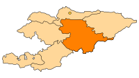
Naryn Province (Kyrgyz: Нарын областы) is the largest province (oblast) of Kyrgyzstan. Its capital is Naryn. The province was established on November 21, 1939 as Tien-Shan Province. On December 20, 1962 the province was dissolved, but on December 11, 1970 re-established again. On October 5, 1988 it was unified with Issyk-Kul Province, and, finally, on December 14, 1990 it got back its present name: Naryn Province.[1]
The main highway runs from the Chinese border at Torugart Pass north to Balykchy on Issyk Kul Lake. It is known as the location of Son-Kul Lake and Chatyr-Kul Lake and Tash Rabat. Naryn countryside
The population of Naryn oblast is 99% Kyrgyz. The economy is dominated by animal herding (sheep, horses, yaks), with wool and meat as the main products. Mining of various minerals developed during the Soviet era has largely been abandoned as uneconomical. Today the oblast is considered to be the poorest region in the country, but also the most typically Kirgyz. It boasts beautiful mountains, alpine pastures and Son-Kul Lake which during summer months attracts large herds of sheep and horses with their herders and their yurts.
Basic Socio-Economic Indicators
- Population: 271,000 (assessment for 1 January 2009) including 17.4% - urban, and 82.6% - rural population[2]
- Employed population: 89,300 (2008) [3]
- Registered Unemployed Population: 6,922 (2008)[4]
- Export: 0.9 million US dollars (2008)[5]
- Import: 4.0 million US dollars (2008) [6]
- Direct Foreign Investments: 1,1 million US dollars (in 2008)[7]
Districts of Naryn
Naryn Province is divided administratively into 5 districts [8]
 Horses grazing near Son-Kul
District Capital Ak-Talaa District Baetov At-Bashi District At-Bashi Jumgal District Chaek Kochkor District Kochkor Naryn District Naryn References
- ^ Brief Description of Naryn Province (in Russian)
- ^ National Committee on Statistics (in Kyrgyz/Russian)
- ^ National Committee on Statistics (in Kyrgyz/Russian)
- ^ National Committee on Statistics (in Kyrgyz/Russian)
- ^ National Committee on Statistics (in Kyrgyz/Russian)
- ^ National Committee on Statistics (in Kyrgyz/Russian)
- ^ National Committee on Statistics (in Kyrgyz/Russian)
- ^ Kyrgyzstan - Джалал-Абадская область
Laurnnce Mitchell, Kyrgyzstan, Bradt Travel Guides, 2008

Chuy Province Issyk Kul Province Jalal-Abad Province 
 Naryn Province

Osh Province  Xinjiang, China
Provinces (Oblasts) of Kyrgyzstan 
 Categories:
- Kyrgyzstan geography stubs
- Naryn Province
- Provinces of Kyrgyzstan


Wikimedia Foundation. 2010.