- North Bay/Jack Garland Airport
-
North Bay Airport
North Bay/Jack Garland Airport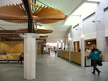
IATA: YYB – ICAO: CYYB
– WMO: 71731Summary Airport type Public Owner Municipality of North Bay Operator North Bay Jack Garland Airport Corporation Serves North Bay, Ontario Location Hornell Heights Elevation AMSL 1,215 ft / 370 m Coordinates 46°21′50″N 079°25′27″W / 46.36389°N 79.42417°WCoordinates: 46°21′50″N 079°25′27″W / 46.36389°N 79.42417°W Website Map Location in Ontario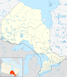
 CYYB
CYYBRunways Direction Length Surface ft m 08/26 10,004 3,049 Asphalt 18/36 4,492 1,369 Asphalt 13/31 2,500 762 Turf Statistics (2010) Aircraft movements 45,177 Source: Canada Flight Supplement[1]
Environment Canada[2]
Movements from Statistics Canada[3]North Bay Airport or North Bay/Jack Garland Airport (IATA: YYB, ICAO: CYYB) in North Bay, Ontario, Canada is located at Hornell Heights, 4 NM (7.4 km; 4.6 mi) north-northeast of the city. The airport serves as a North American Aerospace Defense Command (NORAD) base.
The airport is named in memory of Jack Garland, a longtime Member of Parliament for North Bay's Nipissing electoral district. Until 2004 it hosted an annual airshow during North Bay's Heritage Festival, with a large military component.
The airport is classified as an airport of entry by NAV CANADA and is staffed by the Canada Border Services Agency. CBSA officers at this airport currently can handle general aviation aircraft only, with no more than 15 passengers.[1]
The Airport is home to the Canadore College's aviation campus which houses their aviation programs. Final assembly of the Bombardier 415 aircraft is completed at the airport, opened in 1999.
The airport houses CFB North Bay, which has operated from 1938 (as RCAF North Bay Station until 1966) to the present.[4]
The city has owned the airport since 1998 after transfer from Transport Canada and North Bay Jack Garland Airport Corporation has run it since 2003.[4]
Contents
Airlines and destinations
Airlines Destinations Air Canada Express operated by Jazz Air Toronto-Pearson Essential Helicopters Charter Bearskin Airlines Ottawa, Sudbury Voyageur Airways Charter Technical information
General
- Latitude/Longitude: 46° 21' 50" north, 079° 25' 27" west
- Elevation: 1,215 ft (370 m) AMSL
- Magnetic Variation: 12° west
Terminal
The first terminal was constructed in 1938 to house a small waiting area on the ground floor and control tower on the second.[5] Upgrades after World War II lead to the second terminal being built in 1963. The second terminal has been renovated (completed 2010)[6] to accommodate sole civilian use since 2006.[4]
- 3 gates
- 6 Airline check-in counters
- rental car kiosk
- restaurant - Aramark Canada
- lounges
- CBSA
- First Aid station
- Baby/Parent Room
- Disabled Access/Facilities
- Cafeteria
- Bar
- Newsstand
- Taxi stand
- National Car Rental and Enterprise Car Rental booths
The airport, operated by the North Bay Jack Garland Airport Corporation, is certified by Transport Canada.
 Jack Garland Airport
Ground Transportation
Besides travel by car, the airport is serviced by local taxis and North Bay Transit. An outdoor parking lot next to the terminal has 100 regular and 4 acessible spots.
Runways
- Runway 08/26: 10,004 × 200 ft (3,049 × 61 m), paved, lighted, VASI type 2 approach lighting for both ends.
- Runway 18/36: 4,492 × 150 ft (1,369 × 46 m) paved, lighted, PAPI type 1 approach lighting for both ends.
- Runway 13/31: 2,500 × 75 ft (762 × 23 m), turf, unlighted.
There is also a glider/ski area of 2,000 × 75 ft (610 × 23 m).
Communications
- Mandatory Frequency/ATF: North Bay Radio/Traffic, 118.3 MHz (VDF no longer available as of 1 January 2008)
- RCO: London Radio, 126.7 MHz
- ATIS: 124.9 MHz
- PAL: Toronto Centre, 121.225 MHz
- VOT: 110.4 MHz
- NDBs: North Bay (YB), 394 kHz, 1.9 NM (3.5 km; 2.2 mi) 129° to airport; YELLEK (ZYB), 404 kHz, 3.8 NM (7.0 km; 4.4 mi) 77° to airport
- VOR/DME: North Bay (YYB), 115.4 MHz/Channel 101, at airport
- ILS: Runway 08/26, 110.9 MHz
FBOs
Overnight parking is available through the main airport authority.
- Weisflock Aviation (Shell): 100LL and Jet-A fuel.
- Voyageur Airport Services (Esso): Jet-A fuel only.
Airport managers
- Jim Albertie (father of Frank);
- John Murphy;
- John David (1998 - 1999);
- Owen Andrusiak (1999 - 2003);
- Rick Cunningham (2003 - )
Incidents & accidents
An Air Canada Jazz Flight ran off the runway at YYB on arrival from YYZ. All 15 passengers escaped without injury.
See also
References
- ^ a b Canada Flight Supplement. Effective 0901Z 20 October 2011 to 0901Z 15 December 2011
- ^ Synoptic/Metstat Station Information
- ^ Total aircraft movements by class of operation — NAV CANADA flight service stations
- ^ a b c http://www.northbayairport.com/history.asp
- ^ http://www.vintagepostcards.org/aviation.htm
- ^ http://www.mitchellarchitects.ca/index.php#mi=2&pt=1&pi=10000&s=0&p=2&a=0&at=0
External links
- North Bay Airport at the city web site
- North Bay Airport
- Past three hours METARs, SPECI and current TAFs for North Bay/Jack Garland Airport from NAV CANADA as available.
Airports in Ontario with Scheduled Flights Major Minor Attawapiskat · Big Trout Lake · Cat Lake · Deer Lake · Dryden Regional · Fort Albany · Fort Frances Municipal · Fort Hope · Fort Severn · Kapuskasing · Kasabonika · Kashechewan · Keewaywin · Kenora · Kingfisher Lake · Kingston/Norman Rogers · Lansdowne House · Moosonee · Muskrat Dam · North Bay/Jack Garland · North Spirit Lake · Peawanuck · Pickle Lake · Pikangikum · Poplar Hill · Red Lake · Round Lake (Weagamow Lake) · Sachigo Lake · Sandy Lake · Sarnia (Chris Hadfield) · Sioux Lookout · Summer Beaver · Timmins · Toronto/Buttonville Municipal Airport · Webequie · Wunnummin LakeAirports in Canada By name A–B · C–D · E–G · H–K · L–M · N–Q · R–S · T–ZBy location indicator CA · CB · CC · CD · CE · CF · CG · CH · CI · CJ · CK · CL · CM · CN · CO · CP · CR · CS · CT · CV · CW · CY · CZBy province/territory National Airports System Calgary · Charlottetown · Edmonton · Fredericton · Gander · Halifax · Iqaluit · Kelowna · London · Moncton · Montréal-Mirabel · Montréal-Trudeau · Ottawa · Prince George · Québec · Regina · Saint John · St. John's · Saskatoon · Thunder Bay · Toronto · Vancouver · Victoria · Whitehorse · Winnipeg · YellowknifeRelated List of airports by ICAO code: C · List of defunct airports in Canada · List of heliports in Canada · List of international airports in Canada · National Airports System · Operation Yellow RibbonCategories:- Airports in Ontario
- Buildings and structures in North Bay, Ontario
- Transportation in North Bay, Ontario


Wikimedia Foundation. 2010.