- Okhotsk Plate
-
 Map of the Okhotsk Plate and its neighbouring plates
The Okhotsk Plate is a tectonic plate covering the Sea of Okhotsk, the Kamchatka Peninsula, and Eastern Japan. It was formerly considered a part of the North American Plate, but recent studies indicate that it is an independent plate, bounded on the north by the North American Plate.[1] The boundary is a left-lateral moving transform fault, the Ulakhan Fault. On the east, the plate is bounded by the Pacific Plate at the Kuril-Kamchatka Trench and the Japan Trench, on the south by the Philippine Sea Plate at the Nankai Trough, on the west by the Eurasian Plate, and possibly on the southwest by the Amurian Plate.
The boundary between Okhotsk Plate and Amurian Plate might be responsible for many strong earthquakes that occurred in the Sea of Japan as well as in the Sakhalin island, such as the MW7.1 (MS7.5 according to other sources) earthquake of May 27, 1995 in northern Sakhalin.[2][3][4] The earthquake devastated Neftegorsk, and the town was not rebuilt after the earthquake.
The boundary between Okhotsk Plate and Pacific Plate is a subduction zone, where Pacific Plate subducts beneath the Okhotsk Plate. Many strong megathrust earthquakes occurred here, some of them among the largest on world record, including the Kamchatka earthquakes of 1737 (estimated M9.0~9.3) and 1952 (M9.0). Such strong megathrust earthquakes can also occur near the Kuril Islands, as the M8.3 earthquake of November 15, 2006,[5][6] Hokkaido, as the M8.3 earthquake of September 26, 2003[7][8] and the M9.0 2011 Tōhoku earthquake off the coast of Honshu.
GPS measurements and other studies show that the Okhotsk Plate is slowly rotating in a clockwise direction. Models indicate that it rotates 0.2 deg/Myr about a pole located north of Sakhalin.[9]
References
- Notes
- ^ Apel et al., 2006; and Seno et al., 1996
- ^ Tamura, Makoto; et al. (2002). "The ShalIow Seismicity in the Southern Part of Sakhalin". Geophysical Bulletin of Hokkaido University 65: 127–142. http://eprints.lib.hokudai.ac.jp/dspace/bitstream/2115/14308/1/65_p127-142.pdf.
- ^ "Earthquake Information for 1995". USGS. http://earthquake.usgs.gov/earthquakes/eqarchives/year/1995/.
- ^ Arefiev, S. S.; et al. (2006). "Deep structure and tomographic imaging of strong earthquake source zones". Izvestiya Physics of the solid Earth 42 (10): 850–863. doi:10.1134/S1069351306100090.
- ^ http://ieeexplore.ieee.org/Xplore/login.jsp?url=/iel5/4231073/4231074/04231097.pdf?temp=x
- ^ http://earthquake.usgs.gov/eqcenter/eqinthenews/2006/usvcam/
- ^ Watanabe, Tomoki; et al. (2006). "Seismological monitoring on the 2003 Tokachi-oki earthquake, derived from off Kushiro permanent cabled OBSs and land-based observations". Tectonophysics 426 (1–2): 107–118. doi:10.1016/j.tecto.2006.02.016.
- ^ http://earthquake.usgs.gov/eqcenter/eqinthenews/2003/uszdap/
- ^ Apel, et al., 2006
- Bibliography
- Apel, E. V., R. Bürgmann, G. Steblov, N. Vasilenko, R. King, and A. Prytkov (2006). Independent active microplate tectonics of northeast Asia from GPS velocities and block modeling, Geophys. Res. Lett., 33, L11303, doi:10.1029/2006GL0260772.
- Seno, Tetsuzo; Sakurai, Taro; Stein, Seth (1996). "Can the Okhotsk plate be discriminated from the North American plate?". Journal of Geophysical Research 101 (B5): 11305–11315. doi:10.1029/96JB00532.
External links
- Okhotsk Plate Modeling
- Joint US-Russia Workshop on the Plate Tectonic Evolution of Northeast Russia, Dec. 2004
Tectonic plates Major 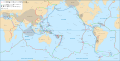
Minor Other Aegean Sea · Altiplano · Amurian · Anatolian · Apulian · Australian · Balmoral Reef · Banda Sea · Bird's Head · Burma · Capricorn · Caroline · Conway Reef · Easter · Explorer · Falklands · Futuna · Galapagos · Gonâve · Gorda · Greenland · Halmahera · Iberian · Indian · Iranian · Juan Fernández · Kerguelen · Kermadec · Kula · Madagascar · Manus · Maoke · Mariana · Molucca Sea · New Hebrides · Niuafo'ou · North Andes · North Bismarck · North Galapagos · Nubian · Okhotsk · Okinawa · Panama · Pelso · Philippine Mobile Belt · Rivera · Sangihe · Seychelles · Shetland · Solomon Sea · Somali · South Bismarck · South Sandwich · Sri Lanka · Sunda · Timor · Tisza · Tonga · Woodlark · YangtzeAll Tectonic plates of East Asia (Eurasian Plate-Pacific Plate Convergence Zone) Large Small Faults and rift zones Baikal Rift Zone · Fukozu Fault · Idosawa Fault · Itoigawa-Shizuoka Tectonic Line · Izu-Bonin-Mariana Arc · Izu Convergence Zone · Japan Median Tectonic Line · Longmenshan Fault · Neodani Fault · Nojima Fault · Northeastern Japan Arc · Philippine Fault System · Senya Fault · Tanna Fault · Ulakhan FaultTrenches and troughs Kuril Trench · Mariana Trench · Japan · Izu-Ogasawara Trench · Japan Trench · Nankai Trough · Sagami Trough · Suruga Trough · Okinawa Trough · Ryukyu Trench · Philippines: · North Luzon Trough · West Luzon Trough · Manila Trench · Philippine Trench · Cotabato Trench · East Luzon Trench · Sulu Trench · Negros Trench · Palawan Trench ·Other Boso Triple Junction
This tectonics article is a stub. You can help Wikipedia by expanding it.

