- Mount Nonotuck
-
Mount Nonotuck 
View from Mount Nonotuck.
From History of the Connecticut Valley, Massachusetts Vol 1 1879, by Louis EvertsElevation 827 ft (252 m) Location Location Holyoke, Massachusetts Range Mount Tom Range / Metacomet Ridge Coordinates 42°16′48″N 72°37′13″W / 42.28°N 72.62028°WCoordinates: 42°16′48″N 72°37′13″W / 42.28°N 72.62028°W Geology Type fault-block igneous Age of rock 200 Ma Climbing Easiest route Auto road Mount Nonotuck, 827 feet (252 m), is the northernmost peak of the Mount Tom Range of traprock mountains located in the Connecticut River Valley of Massachusetts and part of the larger Metacomet Ridge which stretches from Long Island Sound to nearly the Vermont border. Rugged and considered scenic, the peak rises steeply from the river valley 700 feet (210 m) below. It is located within the town of Holyoke.[1]
The 110-mile (180 km) Metacomet-Monadnock Trail, maintained by the Berkshire Chapter of the Appalachian Mountain Club, crosses Mt. Nonotuck, and a seasonal auto road (closed to vehicles indefinitely due to deteriorating conditions, hikers still welcome) climbs to a small parking lot just beneath the summit. During the winter, the auto road is often used for cross country skiing.[2]
Contents
History
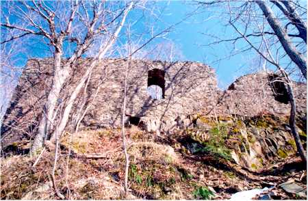
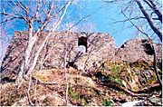 Eyrie House ruins, 2003
In 1861, following the success of the hotel on the summit of Mount Holyoke across the river, William Street opened a summit hotel on Mount Nonotuck and named it Eyrie House. The hotel was closer to the Connecticut River and therefore more accessible than the hotel on Mount Holyoke, which spurred the owners of the latter establishment to build a rail line and a ferry dock from the river to the base of Mount Holyoke. The hotel burned down in 1901 when Street attempted to cremate two horses on the mountain and lost control of the fire, leaving only the cellar holes and the walls of the stone understory standing. The hotel was subsequently included in the Mount Tom Reservation managed by the Commonwealth of Massachusetts. The Connecticut River Oxbow (now a lake), immortalized by the famous landscape painter Thomas Cole just before natural flooding and erosion separated it from the Connecticut River, is visible from the ruins.[3][4]
Geology and ecology
Mount Nonotuck, like much of the Metacomet Ridge, is composed of basalt, also called traprock, a volcanic rock. The mountain formed near the end of the Triassic Period with the rifting apart of the North American continent from Africa and Eurasia. Lava welled up from the rift and solidified into sheets of strata hundreds of feet thick. Subsequent faulting and earthquake activity tilted the strata, creating the cliffs and ridges of Mount Nonotuck.[5] Hot, dry upper slopes, cool, moist ravines, and mineral-rich ledges of basalt talus produce a combination of microclimate ecosystems on the mountain that support plant and animal species uncommon in greater Massachusetts.[6] (See Metacomet Ridge for more information on the geology and ecosystem of Mount Nonotuck).
See also
References
- ^ The Metacomet-Monadnock Trail Guide. 9th Edition. The Appalachian Mountain Club. Amherst, Massachusetts, 1999.
- ^ Ryan, Christopher. "Mt. Tom Reservation" 3rd ed. Map. Hamilton I. Newall Printing, Amherst, Massachusetts. 1994.
- ^ Mt. Holyoke Range Historical Timeline Cited November 27, 2007.
- ^ Roque, Oswaldo Rodriguez (1982). "The Oxbow" by Thomas Cole: Iconography of an American Landscape Painting. Metropolitan Museum Journal. pp. 63-7.
- ^ Raymo, Chet and Maureen E. Written in Stone: A Geologic History of the Northeastern United States. Globe Pequot, Chester, Connecticut, 1989.
- ^ Farnsworth, Elizabeth J. "Metacomet-Mattabesett Trail Natural Resource Assessment." 2004. PDF wefile cited November 1, 2007.
External links
Categories:- Mount Tom Range
- Holyoke, Massachusetts
- Mountains of Massachusetts
- Landforms of Hampden County, Massachusetts

Wikimedia Foundation. 2010.