- Circum-Baikal Railway
-
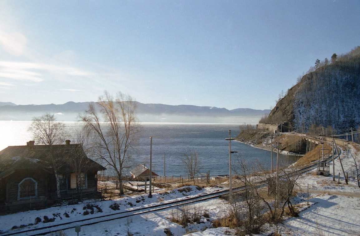
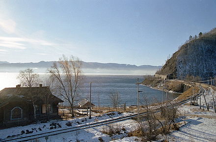 The Circum-Baikal Railway in the winter
The Circum-Baikal Railway (Russian: Кругобайка́льская желе́зная доро́га or Кругобайка́лка, abbreviated "КБЖД") is a historical railway in Irkutsk region of Russia. It runs along the Northern shore of the Southern extremity of the lake from the town of Slyudyanka to the Baikal settlement. Until the middle of the 20th century Circum-Baikal railway was part of the main line of Trans-Siberian Railway; later on, however, a duplicate section of the railway was built. Sometimes called a unique achievement in engineering,[1] the Circum-Baikal is one of the picturesque sights of the area around Lake Baikal.
Contents
History
When the Siberian railway, later called the "Trans-Siberian-railway" was under design, it was divided into seven sections. Circum-Baikal railway was one of them from Irkutsk to the Mysovaya wharf (now the town of Babushkin on the southeastern shore of Lake Baikal.
Survey work
The first exploration of a possible route for the first section of the Circum-Baikal, from Irkutsk to Lake Baikal, was carried out in 1894. Initially the surveyors proposed to build a pontoon bridge and have the railway go down the right (east) bank of the Angara River (the left bank was too built up); however, later this variant was found to be inexpedient, as the level of water in Angara was subject to fluctuations, and during spring thaws crossing the river would have been difficult. Therefore the planners decided to establish the railway from Irkutsk along the left bank.
The construction of the railway along Angara from Irkutsk to Cape Baranchik (Port Baikal) on Lake Baikal was carried out in 1896-1900, costing a total of 3.47 million rubles. In the meantime, East of the lake the railway from Sretensk was completed up to Mysovaya on the east shore of Lake Baikal. With the purpose of establishing a through railway connection, before the Circum-Baikal was finished, it was decided to link the shores of the lake with a railway ferry. The trains were carried on special ice breaker-ferries "Baikal" and "Angara". In the cold winter of 1903/04 when the ice breakers were not strong enough to break the ice, a railway line was laid on the ice, and the cars were drawn by draft animals.
Meanwhile, the construction of another section of track, intended to fill the gap in the Transsiberian railroad, was carried out. The routing of its eastern section, from Mysovaya to Kultuk (at the lake's southwestern tip), passing along the flat southern coast of the lake, did not cause disputes. The greatest complexities were caused by the western section, meant to connect Irkutsk and Kultuk. A group of researchers under the direction of the professor Ivan Vasilʹevich Mushketov studied four options for routing this section of the railway:
- from Irkutsk along the left bank of the Irkut River across the Zyrkuzunsky ridge to the Kultuk
- from Irkutsk through the valleys of the Greater Olkha and the Krutaya Guba Rivers and further along the coast of lake Baikal up to the Kultuk settlement
- from the Baikal station to Kultuk along the lake shore
- from Belektui village (located on the Transsiberian railway to the west of Irkutsk) across the Tunkinsky ridge to Kultuk
According to the results of the work of mountain engineering parties, on June 29, 1889 the committee on a construction of the Siberian railway chose the first and third options from these four initial proposals. From 1899 to 1900 final survey work was down, and the engineers preferred to lay the line along the lake shore (i.e., the third option). Despite the difficult terrain along the shoreline, which consisted of a rocky ridge with abrupt slopes, towering above the waters by 270 to 400 m, calculations showed this option to be the most economical.
The final decision on the line was made by the committee on the construction of the Siberian railway on June 22 [O.S. June 9] 1901. The cost of construction of the given piece of road was 52.52 million rubles. The transportation engineer Boleslav Cavrimovich was appointed the construction director.
Construction of the railway
The construction of the Circum-Baikal railway began in late 1899. Originally the efforts of the builders were concentrated on the section from Mysovaya to Tankhoy. Beginning in 1901, the section from Tankhoy to Slyudyanka was laid. The construction of these sections was carried out chiefly by the detainees and hard labourers of the Aleksandrovsky prison.
Workers began construction on the most complex section, from Slyudyanka to the Baikal station, only in the spring of 1902, with the aim of finishing it by 1905. The original plan required the construction of 33 tunnels, at a cost of 5.3 million rubles, a retaining wall for 3.7 million rubles, and viaducts for 1.6 million rubles. With regard to the possible negative impact caused by the lake water, the minimum necessary height of the track route over the water of Baikal was calculated to be 5.33 m. Technical conditions during the arrangement of the double-track sections fixed the bandwidth of the roads at 14 pairs of trains per day.
Owing to the lack of a flat shoreline all the materials (with the exception of stone mined at the site) were brought by water to the site of construction (by barge during the summer, by animal-drawn carts in the winter). The complex terrain of the rocky shore compelled the builders to lay the majority of the route in tunnels or on artificial shelves cut out of the rock; the sides of the railway were strengthened with retaining walls. The workers, already suffering under the hot summers and harsh winters, were required to carry out the majority of the construction by hand.
Every kilometer of the road required the expenditure of about one wagon of explosives. Earthwork was carried out in volume, approximately equal to 400 wagons.[2] Embankments amounted to 28.7% of the length of the road, cutting, to 71.3% (with a great deal in rocky soil).[3] The upper construction of the railroad ways had to be made heavier, using more powerful track and increasing the number of ties. Because of the difficult terrain the minimum radius of the turns was reduced.
The onset of the Russo-Japanese War in 1904 caused an acceleration in railway construction. From 1901 to 1902 about 9 thousand workers were employed on the railroads, while in 1903–1904 the number rose to 13.5. The main efforts were focused on the construction of the railway line itself; therefore, the development work on stations and towns in the path of the line did not take place. Work trains began to circulate on the railway on October 1 [O.S. September 18] 1904 and on October 29 [O.S. October 16] 1905 the line was brought into permanent operation. The length of the railway in its final form from Baikal station to Mysovaya was 244 versts (260 km). The aggregate value of one kilometer of the Circum-Baikal railway was about 130 thousand rubles (compared to 93 thousand rubles on the other legs of the Trans-Siberian Railway).[2]
Active operation
When the Circum-Baikal railway was put into operation, the Trans-Siberian railway around Baikal was linked, and began to be used to transport goods and passengers. The Circum-Baikal was called the "golden buckle on the steel belt of Russia".
Initially, only one track was built; from 1911 to 1914 the construction of a second track was undertaken, which increased capacity of the Circum-Baikal to 48 pairs of trains a day. In this stage of the construction of bridges and other engineering structures reinforced concrete was introduced as a new material. As part of these works, considerable attention was paid to the construction of stations and station towns. On the section from Baikal to Slyudyanka alone ten stopping points were set up. Measures have been taken to improve traffic safety and protect against landslides.
During the revolutionary events of 1917 and the subsequent civil war the Circum-Baikal was the scene of intense fighting, as evidenced by the mass graves of victims of those events. The Red Army, retreating from the Czechoslovak Legions, blew up the Kirkidaysky tunnel (№ 39, past Slyudyankoy on the way to Mysovaya) on July 23, 1918. The tunnel was later restored, but there was no movement on the line for almost 20 days.
In the 1930s, 40s, and 50s, the villages were actively developed, and homes, barracks for the troops, and power plants were built.
Decline
In 1940, exploration work was initiated to strengthen the track and ensure the safety of traffic on the Circum-Baikal Railway. Owing to the start of the Second World War, the work was completed only by 1947. The group in charge of development came to an unexpected conclusion and citing the enormous cost, proposed not to carry out any work on the railroad along Lake Baikal. Instead they proposed to transform the single track from Irkutsk to Slyudyanka across the mountains into an electric double track.
From 1947 to 1949 an electric transfer railway from Irkutsk to Bolshoy Lug to Slyudyanka was built, noticeably shortening the distance compared with the Circum-Baikal branch line. The main route of the Trans-Siberian Railway was therefore transferred to the new section.
In 1950, construction on the Irkutsk Hydroelectric Power Station plant was begun. In connection with this, the part of the Circum-Baikal railroad from Irkutsk to the town of Baikal that passed along the Angara River was disassembled and in 1956 flooded during the filling of the Irkutsk reservoir (only remnants of dams remained on the shore of the Angara near the town of Baikal). In the end, a modern, "dead-end" route of the Circum-Baikal (from Slyudyanka-2 to Kultuk to Marituy to Baikal). The railway lost its strategic importance, the number of trains on the road dropped sharply, and security was withdrawn from the tunnels and bridges.
Because it was no longer needed, the second track of the Circum-Baikal was disassembled. In the early 1980s, some even proposed the closure of the line, or that an automobile highway be constructed in its place. The villages along the road gradually deteriorated, and people began to abandon their houses. Virtually the only means of communication with the heartland for the residents of these places was the rarely running diesel locomotive, and later a locomotive connected Slyudyanka, Kultuk, and Baikal (Port Baikal is linked to the village of Listvyanka on the opposite shore of the Angara by an automobile ferry).
Landslides and other natural phenomena on the Circum-Baikal
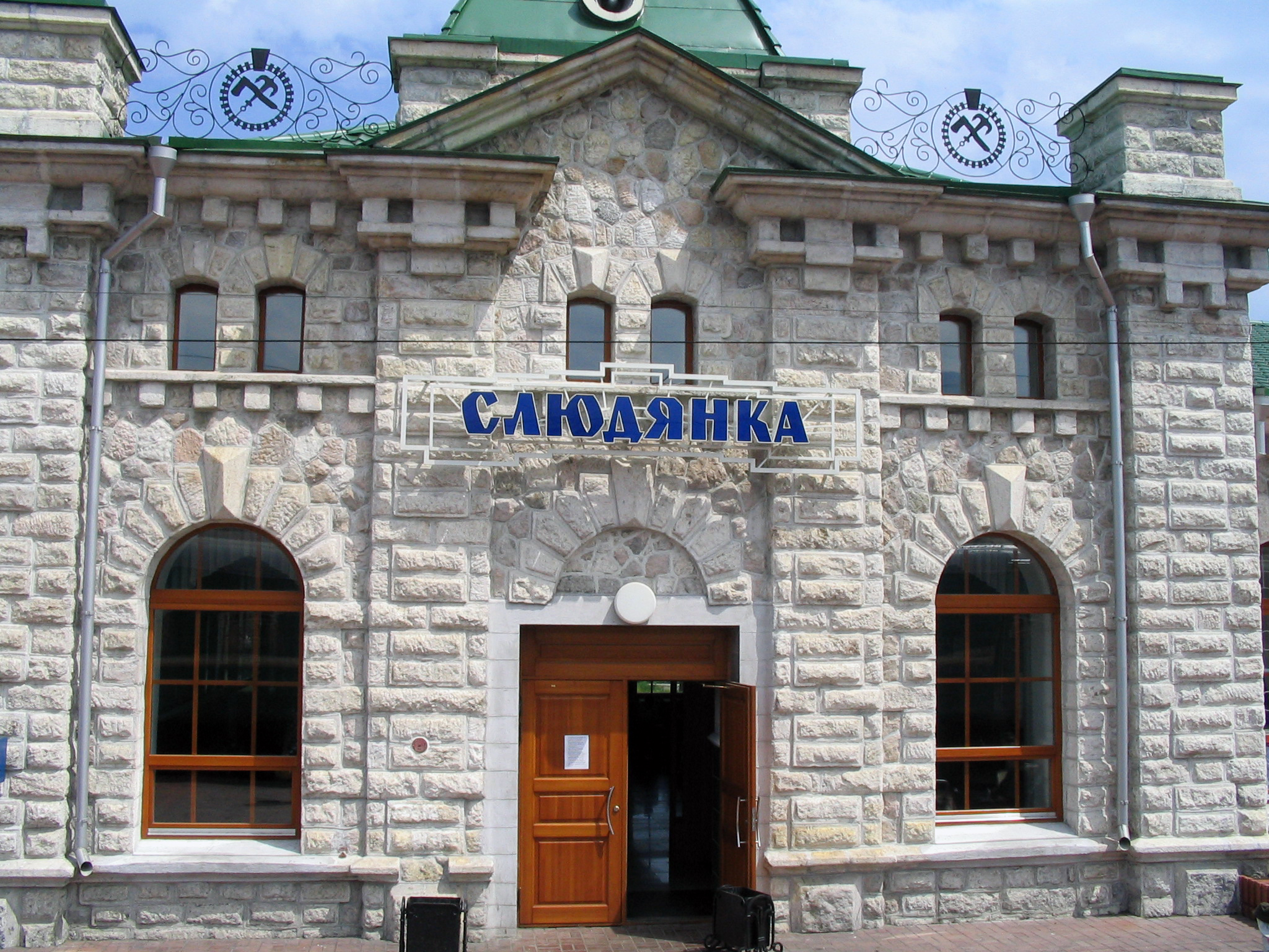
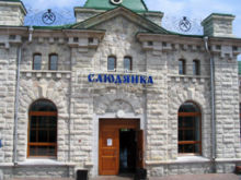 Slyudyanka station
The greatest challenge for the Circum-Baikal Railway was and still is frequent landslides and mud flows. Even at the time of surveying, engineers noted a strong weathering of the rock layers and a great amount of scree. The demolition of the hillside and the steep slopes during the construction of the road provoked a catastrophic intensification of geodynamic processes. Severe landslides occurred during the construction of roads, in particular by tunnel 5 in April 1904 a collapse of about 3000 m3 occurred, and a month before the end of the construction a collapse occurred in tunnel 9 of about 1000 m3, damaging the masonry of the tunnel.
The results of further studies of the rocks along the road showed that they were not as robust as the initial surveys had expected. Moreover, the work associated with the construction of the railroad (particularly the work using explosives) led to the formation of numerous cracks in the rocks below. Having recognized this danger, the authorities agreed on the construction of retaining walls, the stripping of the hillside, and other measures. In some places dangerous sections were rerouted with new tunnels.
Nevertheless, in spite of the work to prevent natural hazards, landslides were a frequent and dangerous phenomenon on the Circum-Baikal, often leading to crashes and interruptions in roadwork. For example:
- In early April 1913 a 4000 m3 landslide occurred on the Irkutsk side at tunnel 16. As a result, the movement of trains was suspended for ten days.
- In April 1929, owing to an earthquake there was a shift in the rock mass at the 143 km mark, which then collapsed from a height of 200 m. The rocks broke the retaining wall and damaged both tracks (some pieces were as much as 30 m3 in size; they were removed through detonation). The delay in traffic as a result of the collapse was 12 hours.
- In 1937, a piece of rock about 4 m in diameter fell on a train car, broke through the roof and the floor, and caused a train crash.
In 1936, the Marituiskaya section was built for safety purposes. It was one of the most complicated sections of railway in the country. In 1939 on the Western Siberian Railway the Travelling Machine Station was built, which was carried out by anti-landslide workers (including even rock-climbers). The levelling and clearing of dangerous slopes has continued until this day.
- In May 1941 at the 87 km mark of the railway, an 8 m3 block, having broken off from height of 30 meters, overturned a moving train together with a steam locomotive into the lake. This boulder, which has become a popular sight, still today holds down some parts of the car. On September 27, 1948 at the 104 mark, a slope collapsed (100 m in length and 35 meters in height), with a general volume of about 20 thousand m3. As a result, circulation stopped for four days.
- In 1982, a collapse of 900 m3 occurred, stopping circulation for a week.
- In 1991, a collapse of about 700 m3 closed off the entrance to a tunnel at the 140 mark.
Among other natural phenomena, mudflows and floods had a negative influence on the Circum-Baikal traffic safety. The greatest activity in this respect occurred on the river Slyudyanka, which runs into Baikal near station 1. On July 29, 1934 a mudflow on this river had catastrophic consequences, carrying off in its wake several apartment houses and covering the station with a thick layer of silt and sand. In 1960 the mudflow on Slyudyanka again washed away train tracks and destroyed a series of dams. Powerful downpours in 1971 caused the strongest floods, which led to the destruction of several bridges and tunnel entrances, as well as a the foundations of a track on the Circum-Baikal (the interruption of traffic lasted almost a week). Another unusual natural phenomenon occurs on the south side of Baikal: the deposition of ice sometimes causes a several-meter heap of ice blocks on the coast, covering the railways with ice.
In 16 years alone, from 1932 to 1947, 721 collapses occurred, of which 502 were without consequences for the railway, 201 closed off a single stage and disturbed the top structure of the railway, and 18 caused train-wrecks and the destruction of the embankment. According to the data of the Eastern Siberian Engineering Service, between 1930 for 1984 about 1200 collapses and mud-flows were recorded. Besides this, about 500 cases of falling of separate stones caused damage to the railway and a rolling-stock.[4] Engineers described trips on the Circum-Baikal as exciting but dangerous.[5]
Current condition
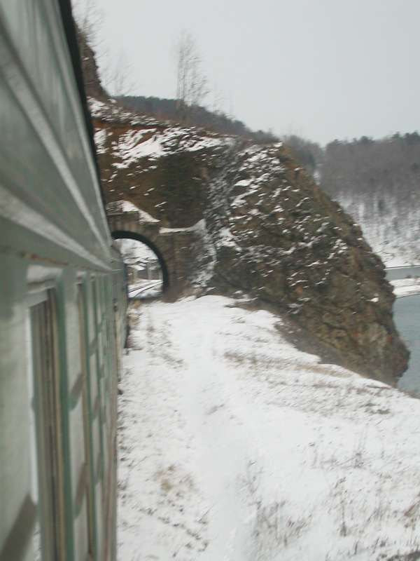
In the present day the Circum-Baikal Railway is the name of an 89-km–long branch covering the route Slyudyanka-2–Kultuk–Maritui–Baikal. Four stations are currently in operation: Kultuk, Maritui, Ulanovo, and Baikal, with one section of double track at 137 km. The Circum-Baikal contains thirty-eight tunnels for a total length of 9063 m (the longest of them, a tunnel through cape Polovinnyj, is 777.5 m long). There are also 15 stone galleries with a total length of 295 m and 3 ferro-concrete galleries with apertures, 248 bridges and viaducts, and 268 retaining walls. The Circum-Baikal has no equal in Russia as to the richness of engineering constructions. The tunnels and stone galleries of the Circum-Baikal are unique in that they were constructed atypically and have not been reconstructed since, conserving the initial plan of architects and engineers of the beginning of the century.
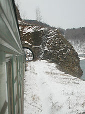 Tunnel on the Circum-Baikal Railway
The kilometers on the modern Circum-Baikal are traditionally measured from the Irkutsk sorting station, which until 1934 was the administrative border between the Tomsk railway and the railway after Baikal. The Baikal station is thus located 72 km from this point of readout, and the Slyudyanka-2 station, at 161 km.
In the 1980s and 1990s, measures were begun to reconstruct and strengthen the railway. Currently, normally one train a day (a diesel locomotive and two cars) runs on the railway. The duration of the trip from Slyudyanka to the Baikal station is four hours and forty minutes. The inhabitants of the roadside settlements call the train a передача, or "transfer", reflecting the value of this transport for the supply of necessary articles such as bread, salt, matches, vodka, and tobacco. Another name given to the train is мотаня (so called because the train rushes or мотается between stations). In addition, tourist trains periodically pass along the Cicum-Baikal, including steam locomotives and retro-style cars. Tourists can also rent handcars.
With the decision of the Irkutsk regional council on December 21, 1982, the section of the Circum-Baikal from Baikal station to Kultuk station was declared an architectural and scenic reserve (it is now part of the Baikal National Park) and put under the state protection. Beginning in the early 1980s the tourist potential of the Circum-Baikal Railway has started to come into its own (the stations, however, were used to a limited degree since the railroad's inception as areas for dachas and recreation). A series of tourist areas are in operation ("Taiga" at 134 km, "Sensation" at 102 km, "Coniferous" at 98 km, "Retro" and the "Silver Key" at 80 km.
Along with actual railway sights, tourists on the Circum-Baikal route are attracted by the numerous nature sanctuaries, including the rocky formations such as "Белая выемка". In the settlements along the Circum-Baikal, especially in Maritui, a number of early twentieth-century in the modernist style are preserved.
The following establishments are also located on the Circum-Baikal:
- at 80 km: a research experimental base, the Center for Preservation of Historical and Cultural Heritage
- at 106 km: the base of a nuclear research institute
- at 119–120 km (Maritui): a research area for students of the Biological and Soil Studies department of the Irkutsk State University
The 100th anniversary of the railway was celebrated in autumn of 2005. For this event the Baikal station was reconstructed, in which an exhibit was opened, devoted to the Circum-Baikal. The Sludyanka station was also rebuilt.
List of stations and stops
Distance (km) Name Location 159 159 km stop Kultuk 156 Kultuk station Kultuk 154 154 km stop 154 km settlement 149 149 km stop Angasolsky village 139 139 km stop Sharyzhalgai village 138 Sharyzhalgai stop Lokomotiv Voluntary Sports Society 137 137 km stop VSZhD Rest stop 134 134 km stop 134 km village 129 129 km stop Balkan village 120 120 km stop Maritui settlement 119 Maritui station Maritui settlement 110 110 km stop Poloviny village 107 107 km stop Ponomareva settlement 106 106 km Ivanovka settlement 102 102 km stop Shumikha village 98 Ulanovo station Khvoiny Tourist Center 80 80 km stop "Retro" Tourist Center 80 79 km stop "Silver Key" Tourist Center 74 74 km stop Baikal settlement 72 Baikal station Baikal settlement Depictions
- The construction of the Circum-Baikal Railway is described in Baikal: A Sacred Sea (1989) by the Siberian writer Kim Balkov
- The Circum-Baikal Railway is praised in a poem by the Irkutsk poet Yuri Levitansky, "И вот расступаются горы" ("Here the mountains part")
- The Trans-Siberian Railway, including the Circum-Baikal section, has been depicted by a number of painters, including Vladimir Tomilovsky, and by photographers such as Igor Berzhinsky and Galina Korobova.
References
- This page was originally translated from the Russian Wikipedia article.
- ^ О Прибайкальском национальном парке на сайте «Особо охраняемые природные территории Российской Федерации» Минприроды РФ
- ^ a b «Из Листвянки на Кругобайкальскую железную дорогу», on the site by Sergei Volkov «Байкальская земля».
- ^ Aleksandrov, N. A. Кругобайкальская железная дорога // Железнодорожный транспорт. — 1991. — № 5.
- ^ Khobta A. V. Кругобайкальская железная дорога. Мысли вслух (chapters from an unpublished book).
- ^ Agalakov V. Подвиг у Байкала // Восточно-Сибирская правда. 1997. No. 31.
Bibliography
- Aleksandrov, N. A. Кругобайкальская железная дорога // Железнодорожный транспорт., 1991, No. 5.
- Восточно-Сибирская магистраль. Путь в 100 лет., Irkutsk, 1998.
- Khobta, A. B. КБЖД — памятник инженерного искусства и уникального ландшафта // Земля Иркутская., 2002, No. 2.
External links
- (English) Circum-Baikal railway, especially Handbook
- (English) Circumbaikal Railway
- (Russian) Кругобайкалка — легендарная железная дорога России Guide to the Circum-Baikal Railway
- (Russian) Кругобайкальская железная дорога — Site created with the financial help of the Open Society Institute (Soros fund)
Categories:- Irkutsk Oblast
- Railway lines in Russia
- Rail transport in Siberia
Wikimedia Foundation. 2010.