- Old Stone Fort (Tennessee)
-
Old Stone Fort
 Entrance Sign to Old Stone Fort
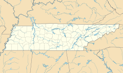

Location: 732 Stone Fort Drive Nearest city: Manchester, Tennessee Coordinates: 35°28′58″N 86°6′28″W / 35.48278°N 86.10778°WCoordinates: 35°28′58″N 86°6′28″W / 35.48278°N 86.10778°W Built: 0-499 A.D. Governing body: TDEC NRHP Reference#: 73001757 Added to NRHP: 1973 The Old Stone Fort is a prehistoric Native American structure located in Coffee County, Tennessee, in the Southeastern United States. The structure was most likely built between 80 and 550 AD during the Middle Woodland period.
The structure is now part of Old Stone Fort State Archaeological Park, one of two archaeological parks in Tennessee (the other being at Pinson Mounds near Jackson). The site is listed on the National Register of Historic Places.
Contents
Geographic setting
 Big Falls on the Duck River, below the Old Stone Fort's northwestern section
The Old Stone Fort is located on a peninsula created by the confluence of the Duck River and the Little Duck River (the section of the Duck River upstream from its confluence with the Little Duck is sometimes called "Barren Fork"). The Duck River forms the peninsula's northwestern boundary, the Little Duck forms the peninsula's southeastern boundary, and a westward bend in the Little Duck forms the peninsula's southern boundary. The walled area of the structure encompasses approximately 50 acres (200,000 m2). (Click for Map)
The Duck River system spills over a limestone-rich shelf of the western Cumberland Plateau known as the Highland Rim. As the Duck and Little Duck approach their convergence, they rapidly drop in elevation, and have cut relatively deep gorges around the peninsula upon which the ancient structure is located. Both gorges are highlighted by a series of substantial waterfalls and whitewater rapids. The natural waterpower in these two gorges attracted entrepreneurs and millwrights throughout the 19th century.
The Old Stone Fort is located entirely within Coffee County, and is situated just west of Manchester, Tennessee. Old Stone Fort State Archaeological Park encompasses 876 acres (3.55 km2) and is managed by the Tennessee Department of Environment and Conservation.
The structure of the Old Stone Fort
 The Old Stone Fort's entrance, with the "pedestal" mounds on the right and left
The walls of the Old Stone Fort consist of stone and earthwork, and are on average approximately 4–6 feet high. The walls originally consisted of an inner and outer layer of crudely stacked rocks and slabs with gravel and earthen fill in between. Over the centuries, the earthen fill has spilled over the rock layers, giving the walls their current mound-like appearance.
The walls can be divided into roughly three sections, with two sections running roughly parallel to the Duck and Little Duck Rivers, and a third section running parallel to the southern rim of the peninsula. The sections paralleling the rivers gradually move inward, away from their respective rivers, and approach one another in a pincer-like formation at the northeastern half of the peninsula. Here, both walls terminate just before converging, allowing for a small entrance. Two ancient "pedestal" mounds— one 35 feet (11 m) in diameter and the other 48 feet (15 m) in diameter— are located on either side of the structure's entrance. The entrance continues through a 120-foot (37 m) L-shaped corridor which opens into the structure's interior.
 The sign describes a structure of the Old Stone Fort
The fort's northwestern walls (following the Duck River) are approximately 1,394 feet (425 m) long, and the southeastern walls (following the Little Duck) are approximately 1,094 feet (333 m) in length. The southern walls, which are basically straight with the exception of an area where the ridge bulges outward, are 2,116 feet (645 m) long. Large open sections are found between both the southern wall and the northwestern wall and the southern wall and the southeastern wall. These areas were probably left open due to the fact that they overlook steep bluffs carved out by the Duck and Little Duck rivers whose waters probably performed the same function as the mounds.
A substantial ditch, known as the "moat", parallels the southern wall at the base of the ridge. This ditch is a natural feature and is actually an abandoned river channel. However, it is not known if this channel was artificially kept open in prehistory.[1]
The Old Stone Fort in recorded history
 Old Stone Fort Mills exhibits in a museum.
By the time Euro-American long hunters and traders arrived in the area in the mid-18th century, a system of well-worn trails traversed the Cumberland Plateau, connecting what is now Middle Tennessee with Georgia and Northern Alabama. One such trail passed near the Old Stone Fort, closely following what is now U.S. Route 41.[2] The ancient structure was no doubt an important landmark to early travelers in the Middle Tennessee area.
The Nickajack Expedition, led by Major James Ore in the latter part of the Chickamauga Wars, was believed to have encamped within the Old Stone Fort en route to the Chickamauga towns.[2] The structure also had an important symbolic significance for early Coffee Countians. The county's first court was held at the "Old Stone Fort Tavern" in 1836, and the county seat was laid out upon "Main Stone Fort Creek."[3]
 The ruins of the Stone Fort Paper Mill near Big Falls at the Old Stone Fort's northwestern section
The powerful Duck River made the Old Stone Fort's peninsula an attractive site for mills as early as 1823, when Samuel Murray built a rope factory on the Little Duck River. Although the factory burned in 1847, it was followed by W.S. Whitman's paper mill further downstream in 1852. In 1862, Whitman built a powder factory adjacent to his paper mill to supply the Confederacy with arms during the Civil War, although the mill was destroyed by Union troops the following year. In 1879, the Stone Fort Paper Company built a large mill near Big Falls on the Duck River. The mill supplied paper to newspapers throughout the Southeast— including the Nashville Banner and the Atlanta Constitution— until the early 20th century. The mill's foundations are still situated on the bluffs overlooking Big Falls, and can be accessed via the Old Stone Fort Loop Trail.[4]
The property upon which the Old Stone Fort was located eventually passed into the hands of the Chumbley family, who had ties to Stone Fort Paper. The Chumbleys, seeking to protect the Old Stone Fort, passed up numerous private offers for the land upon which the ancient structure was located.[5] In 1966, the State of Tennessee finally purchased 400 acres (1.6 km2) of the Chumbley estate that became the core of Old Stone Fort State Archaeological Park.[6] The Old Stone Fort was added to the National Register of Historic Places in 1973.
The Old Stone Fort's builders and function
Who built the Old Stone Fort?
 Looking across the Old Stone Fort's south wall
The Old Stone Fort remained a mystery until the University of Tennessee conducted excavations within the structure in 1966. Throughout the 19th and early 20th century, numerous theories were put forth regarding the identity of the structure's builders, ranging from the overly-simplistic to the exotic.
In 1823, the Pioneer, a Jackson, Tennessee newspaper, argued that the Old Stone Fort was built by Buccaneers from Seville after one of their ships wrecked off the coast of Florida and forced them inland.[7] In the mid-20th century, the discoveries at L'Anse aux Meadows and the supposed recovery of Viking artifacts in various parts of North America led many to believe the Vikings built numerous stone structures throughout the Eastern U.S., including the Old Stone Fort. In 1950, author Zella Armstrong hypothesized that the fort was built by "Welsh-Indian" descendants of Prince Madoc.[8]
The first serious investigation of the Old Stone Fort was conducted by Joseph Jones at the behest of the Smithsonian Institution in 1876, uncovering several prehistoric artifacts. He was followed by Tennessee State Archaeologist P.E. Cox's excavations in 1928, which dug several trenches and analyzed the fort's composition.[9]
In 1966, after the purchase of the Old Stone Fort from the Chumbley estate, the State of Tennessee commissioned the University of Tennessee Department of Anthropology to investigate the structure's origins. After digging a series of trenches and test pits and conducting extensive research, the investigators determined the builders of the structure to be Native Americans of the Middle Woodland period. Charles Faulkner, a member of the excavation team, bases this theory on three findings:
 1966 Entrance Sign.
- Radiocarbon analysis of charcoal samples found within the structure's walls all dated to approximately 30-430 AD, within the Middle Woodland period.[10]
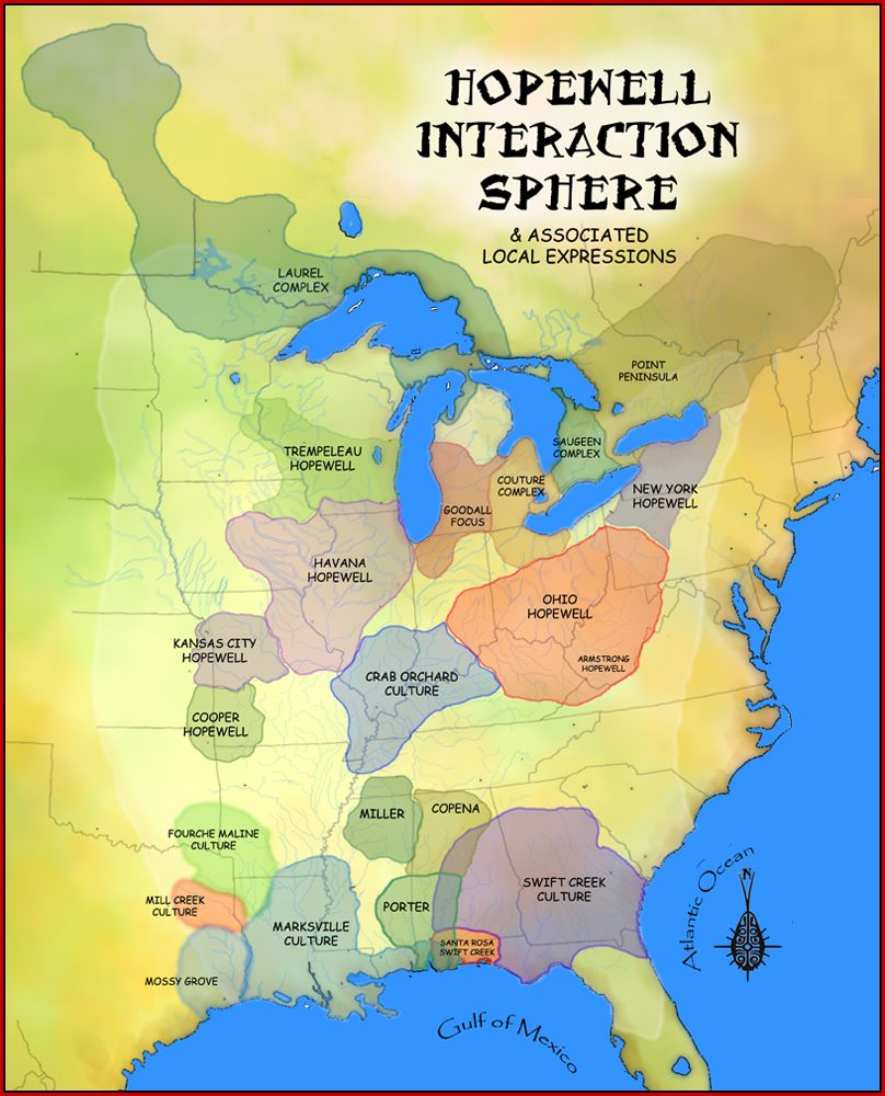
- The structure's composition, setting, and layout is similar to other structures built by Middle Woodland cultures, such as the Hopewell people of Ohio and the Pinson Mound builders in West Tennessee.[11]
- Between 1966 and 1971, five Middle Woodland settlements were discovered within 20 miles (32 km) of the Old Stone Fort, including a substantial habitation area just 3 miles (4.8 km) downstream.[12]
The University of Tennessee investigators also determined that the fort was built gradually over a period of several hundred years, rather than all at once. The builders of the Old Stone Fort are now believed to be two distinct local Middle Woodland cultures known as the McFarland and the Owl Hollow cultures, with the former beginning work on the structure in the 1st century AD and the latter completing it.[13]
What was the purpose of the Old Stone Fort?
 The interior of the Old Stone Fort
For decades, it was largely assumed (as its name implies) that the Old Stone Fort was used for purposes of military defense. Evidence from the 1966 excavations, however, seem to point more to a religious or ceremonial function, rather than a martial function. Faulkner bases this theory on the following points:
- Defensive structures are typically constructed quickly in response to a perceived threat, whereas the Old Stone Fort was constructed gradually, over a period of several centuries.[14]
- The walls alone are not high enough to have been of defensive value, and no evidence of a palisade has been found.[14]
- The area encompassed by the walls is relatively large and its defense would require a force much larger than the typical Middle Woodland fighting force.[14]
- The 1966 excavations turned up almost no cultural artifacts within the walls, which implies that the enclosure was kept clean, and was probably never continuously inhabited by its builders.[15]
The "moat" that parallels the base of the southwestern edge of the peninsula was originally considered artificial, although 20th-century researchers believe this ditch may be a natural dry riverbed.[16]
 The Old Stone Fort Museum.
The Old Stone Fort Museum
The Old Stone Fort Museum, built by Tennessee State Parks, is located near the park entrance. The museum's exhibits interpret the theories regarding the fort's builders, archaeological excavations at the site, small theater, small welcome/gift shop center, historical lineage of early Native Americans, and the culture of its builders. An observation deck atop the museum displays information about the Old Stone Fort and surrounding rivers and views of the Blue Hole Falls.
See also
References
- ^ Information in the section obtained from Charles Faulkner, The Old Stone Fort: Exploring an Archaeological Mystery (Knoxville, Tenn.: University of Tennessee Press, 1971), 3-6, 35-36, 50-51.
- ^ a b Faulkner, The Old Stone Fort, v.
- ^ Basil McMahan, The Mystery of Old Stone Fort (Nashville, Tenn.: Tennessee Book Company, 1965), 10.
- ^ McMahan, The Mystery of Old Stone Fort, 10.
- ^ McMahan, The Mystery of Old Stone Fort, 88.
- ^ Faulkner, The Old Stone Fort, vi.
- ^ McMahan, The Mystery of the Old Stone Fort, 44.
- ^ McMahan, The Mystery of the Old Stone Fort, 65.
- ^ Faulkner, The Old Stone Fort, 8, 19, 34-35.
- ^ Faulkner, The Old Stone Fort, 23-25.
- ^ Faulkner, The Old Stone Fort, 9-18.
- ^ Faulkner, The Old Stone Fort, vi-vii.
- ^ Charles Faulkner, "Old Stone Fort State Archaeological Park." The Tennessee Encyclopedia of History and Culture (2002). Retrieved 28 November 2007.
- ^ a b c Faulkner, The Old Stone Fort, 28-29.
- ^ Faulkner, The Old Stone Fort, 30.
- ^ Faulkner, The Old Stone Fort, 53-55.
External links
- Old Stone Fort State Archaeological Park — official site
- Old Stone Fort - TN History for Kids, park description and photos
 Hopewellian peoples
Woodland period · List of Hopewell sites · Mound builder (people) · List of archaeological periods (North America) Ohio Hopewell Beam Farm · Benham Mound · Cary Village Site · Cedar-Bank Works · Dunns Pond Mound · Ellis Mounds · Ety Enclosure · Ety Habitation Site · Fort Ancient · Fortified Hill Works · Great Hopewell Road · High Banks Works · Hopeton Earthworks · Hopewell Culture National Historical Park · Indian Mound Cemetery · Keiter Mound · Marietta Earthworks · Moorehead Circle · Mound of Pipes · Nettle Lake Mound Group · Newark Earthworks · Oak Mounds · Perin Village Site · Portsmouth Earthworks · Seip Earthworks and Dill Mounds District · Shawnee Lookout · Tremper Mound and Works · Williamson Mound Archeological District
Crab Orchard culture Goodall Focus Goodall Site · Norton Mound GroupHavana Hopewell culture Kansas City Hopewell Marksville culture Miller culture Point Peninsula Complex Swift Creek culture Etowah Indian Mounds · Leake Mounds · Kolomoki Mounds Historic Park · Miner's Creek site, · Nacoochee Mound · Swift Creek mound site · Yearwood siteOther Hopewellian peoples Armstrong culture · Copena culture · Fourche Maline culture · Laurel Complex · Saugeen Complex · Old Stone Fort (Tennessee)Exotic trade items Related topics · Ancient Monuments of the Mississippi Valley · Black drink · burial mound · Calumet (pipe) · Effigy mound · Hopewell pottery · Horned Serpent · Eastern Agricultural Complex · Underwater panther U.S. National Register of Historic Places Topics Lists by states Alabama • Alaska • Arizona • Arkansas • California • Colorado • Connecticut • Delaware • Florida • Georgia • Hawaii • Idaho • Illinois • Indiana • Iowa • Kansas • Kentucky • Louisiana • Maine • Maryland • Massachusetts • Michigan • Minnesota • Mississippi • Missouri • Montana • Nebraska • Nevada • New Hampshire • New Jersey • New Mexico • New York • North Carolina • North Dakota • Ohio • Oklahoma • Oregon • Pennsylvania • Rhode Island • South Carolina • South Dakota • Tennessee • Texas • Utah • Vermont • Virginia • Washington • West Virginia • Wisconsin • WyomingLists by territories Lists by associated states Other  Category:National Register of Historic Places •
  Portal:National Register of Historic Places
Protected Areas of Tennessee Federal National ParksChickamauga and Chattanooga National Military Park · Fort Donelson National Battlefield · Fort Donelson National Cemetery · Shiloh National Cemetery • Shiloh National Military Park • Stones River National Battlefield • Stones River National CemeteryAppalachian National Scenic Trail • Natchez Trace National Scenic Trail • Overmountain Victory National Historic Trail • Trail of Tears National Historic TrailChickasaw • Cross Creeks • Hatchie • Lake Isom • Lower Hatchie • Reelfoot • Tennessee
Wilderness AreasBald River Gorge • Big Frog • Big Laurel Branch • Citico Creek • Cohutta • Gee Creek • Joyce Kilmer-Slickrock • Little Frog Mountain • Pond Mountain • Sampson Mountain • Unaka Mountain
Natchez Trace Parkway • Obed Wild and Scenic RiverState Big Ridge • Booker T. Washington • Cove Lake • Cumberland Mountain • Justin P. Wilson Cumberland Trail • Davy Crockett Birthplace • Fort Loudoun • Frozen Head • Harrison Bay • Hiwassee/Ocoee • Indian Mountain • Norris Dam • Panther Creek • Pickett • Red Clay • Roan Mountain • Sycamore Shoals • Warriors' Path
Bicentennial Capitol Mall • Bledsoe Creek • Burgess Falls • Cedars Of Lebanon • Cordell Hull Birthplace • David Crockett • Dunbar Cave • Edgar Evins • Fall Creek Falls • Harpeth River • Henry Horton • Johnsonville • Long Hunter • Montgomery Bell • Mousetail Landing • Old Stone Fort • Port Royal • Radnor Lake • Rock Island • Sgt. Alvin C. York • South Cumberland • Standing Stone • Tims Ford
Big Cypress Tree • Big Hill Pond • Chickasaw • Fort Pillow • Meeman-Shelby • N. B. Forrest • Natchez Trace • Paris Landing • Pickwick Landing • Pinson Mounds • Reelfoot Lake • Ross Cross Landing • T.O. Fuller
Bledsoe • Cedars of Lebanon • Chickasaw • Chuck Swan • Franklin • Lewis • Lone Mountain • Martha Sundquist • Natchez Trace • Pickett • Prentice Cooper • Scott • Standing Stone • Stewart
Honey Creek * Piney Falls • Laurel-Snow • North Chickamauga Creek Gorge • Stinging Fork Falls • Virgin Falls
Other OtherTennessee Department of Environment and Conservation (web) - Tennessee Department of Agriculture {web} Categories:- Hopewellian peoples
- Native American culture
- Archaeological sites on the National Register of Historic Places in Tennessee
- Native American museums in Tennessee
- Archaeology museums in Tennessee
- Tennessee state parks
- National Register of Historic Places in Tennessee
- Forts in Tennessee
- Museums in Coffee County, Tennessee
- Protected areas of Coffee County, Tennessee
- Pre-state history of Tennessee


Wikimedia Foundation. 2010.