- Crestwood, Missouri
-
Crestwood, Missouri — City — Location of Crestwood, Missouri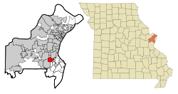
Coordinates: 38°33′27″N 90°22′34″W / 38.5575°N 90.37611°WCoordinates: 38°33′27″N 90°22′34″W / 38.5575°N 90.37611°W Country United States State Missouri County St. Louis Area - Total 3.6 sq mi (9.3 km2) - Land 3.6 sq mi (9.3 km2) - Water 0.0 sq mi (0.0 km2) Elevation 620 ft (189 m) Population (2010) - Total 11,912 - Density 3,317.4/sq mi (1,280.9/km2) Time zone Central (CST) (UTC-6) - Summer (DST) CDT (UTC-5) ZIP code 63126
(St. Louis (Sappington))FIPS code 29-17218[1] GNIS feature ID 0755941[2] Crestwood is a city in St. Louis County, Missouri, United States, part of the Metropolitan Statistical Area known as Greater St. Louis. The population was 11,912 at the 2010 census.[3]
Contents
Geography
Crestwood is located at 38°33′27″N 90°22′34″W / 38.5575°N 90.37611°W (38.557552, -90.376152)[4].
According to the United States Census Bureau, the city has a total area of 3.6 square miles (9.3 km2), all of it land.
Crestwood is home to several public parks, including Crestwood Park, featuring baseball and soccer fields, a playground, and tennis courts, and Whitecliff Park, featuring the Crestwood Community Center and the Crestwood Aquatic Center, a public water park. Adjacent to Whitecliff Park in the small city of Grantwood Village is the animal reserve owned by Anheuser-Busch called Grant's Farm, which is free and open to the public during the summer. Grant's Farm, now home to free-roaming buffalo, zebras, and deer among other animals, is located on property formerly owned by president Ulysses S. Grant in the period between the Mexican War and the Civil War.
Crestwood is the burial place of Sgt. John Sappington. He was a Revolutionary War soldier who was a personal bodyguard to Gen. George Washington at Valley Forge. He was also one of the pioneers at Fort Boonesborough in Madison County, Kentucky. The Sappingtons were large land owners in the area, and Mark and Thomas Sappington's homes still stand in the vicinity. The Sappington Cemetery is maintained by the City of Crestwood, and several Sappington descendants still pass through to maintain the family graves.
Demographics
As of the census[1] of 2000, there were 11,863 people, 5,111 households, and 3,521 families residing in the city. The population density was 3,296.2 people per square mile (1,272.3/km²). There were 5,214 housing units at an average density of 1,448.7 per square mile (559.2/km²). The racial makeup of the city was 96.41% White, 0.72% African American, 0.19% Native American, 1.45% Asian, 0.01% Pacific Islander, 0.26% from other races, and 0.96% from two or more races. Hispanic or Latino of any race were 1.00% of the population.
There were 5,111 households out of which 24.0% had children under the age of 18 living with them, 57.8% were married couples living together, 8.7% had a female householder with no husband present, and 31.1% were non-families. 27.5% of all households were made up of individuals and 14.9% had someone living alone who was 65 years of age or older. The average household size was 2.32 and the average family size was 2.83.
In the city the population was spread out with 20.0% under the age of 18, 5.9% from 18 to 24, 24.3% from 25 to 44, 25.0% from 45 to 64, and 24.8% who were 65 years of age or older. The median age was 45 years. For every 100 females there were 88.8 males. For every 100 females age 18 and over, there were 85.3 males.
The median income for a household in the city was $54,185, and the median income for a family was $64,240. Males had a median income of $46,473 versus $31,934 for females. The per capita income for the city was $26,793. About 1.5% of families and 2.4% of the population were below the poverty line, including 3.8% of those under age 18 and 1.6% of those age 65 or over.
References
- ^ a b "American FactFinder". United States Census Bureau. http://factfinder.census.gov. Retrieved 2008-01-31.
- ^ "US Board on Geographic Names". United States Geological Survey. 2007-10-25. http://geonames.usgs.gov. Retrieved 2008-01-31.
- ^ "Race, Hispanic or Latino, Age, and Housing Occupancy: 2010 Census Redistricting Data (Public Law 94-171) Summary File (QT-PL), Crestwood city, Missouri". U.S. Census Bureau, American FactFinder 2. http://factfinder2.census.gov. Retrieved October 19, 2011.
- ^ "US Gazetteer files: 2010, 2000, and 1990". United States Census Bureau. 2011-02-12. http://www.census.gov/geo/www/gazetteer/gazette.html. Retrieved 2011-04-23.
External links
Greater St. Louis Illinois · Missouri · United States of America Topics 
Central city Largest cities
(over 20,000 in 2000)Affton CDP · Alton · Ballwin · Belleville · Chesterfield · Collinsville · East St. Louis · Edwardsville · Ferguson · Florissant · Granite City · Hazelwood · Kirkwood · Maryland Heights · Mehlville CDP · Oakville CDP · O'Fallon, Illinois · O'Fallon, Missouri · Saint Charles · St. Peters · Spanish Lake CDP · University City · Webster Groves · WildwoodLargest towns
and villages
(over 10,000 in 2000)Arnold · Bellefontaine Neighbors · Berkeley · Bridgeton · Cahokia · Clayton · Concord CDP · Crestwood · Creve Coeur · Fairview Heights · Farmington · Festus · Glen Carbon · Godfrey · Jennings · Lake St. Louis · Lemay CDP · Manchester · Overland · St. Ann · Swansea · Town and Country · Washington · Wentzville · Wood RiverMissouri Counties Franklin · Jefferson · Lincoln · St. Charles · Saint Francois · St. Louis City · St. Louis County · Warren · WashingtonIllinois Counties Subregions Categories:- Cities in St. Louis County, Missouri
- Communities on U.S. Route 66


Wikimedia Foundation. 2010.