- Mehlville, Missouri
-
Mehlville, Missouri — CDP — Location of Mehlville, Missouri
Coordinates: 38°30′15″N 90°18′46″W / 38.50417°N 90.31278°WCoordinates: 38°30′15″N 90°18′46″W / 38.50417°N 90.31278°W Country United States State Missouri County St. Louis Area – Total 7.6 sq mi (19.6 km2) – Land 7.4 sq mi (19.1 km2) – Water 0.2 sq mi (0.5 km2) Elevation 638 ft (194 m) Population (2010) – Total 28,380 – Density 3,750.2/sq mi (1,448/km2) Time zone Central (CST) (UTC-6) – Summer (DST) CDT (UTC-5) ZIP 63125 Area code(s) 314 FIPS code 29-47180[1] GNIS feature ID 0765728[2] Mehlville is a census-designated place (CDP) in St. Louis County, Missouri, United States, and an inner-ring suburb of St. Louis. The population was 28,380 at the 2010 census.[3]
Contents
Geography
Mehlville is located at 38°30′15″N 90°18′46″W / 38.50417°N 90.31278°W (38.504303, -90.312745)[4]. According to the United States Census Bureau, the CDP has a total area of 7.6 square miles (20 km2), of which 7.4 square miles (19 km2) is land and 0.2 square miles (0.52 km2), or 2.77%, is water.
Demographics
As of the census[1] of 2000, there were 28,822 people, 12,541 households, and 7,775 families residing in the CDP. The population density was 3,913.6 people per square mile (1,512.0/km²). There were 12,982 housing units at an average density of 1,762.8/sq mi (681.0/km²). The racial makeup of the CDP was 97.08% White, 0.75% African American, 0.13% Native American, 1.77% Asian, 0.02% Pacific Islander, 0.34% from other races, and 0.61% from two or more races. Hispanic or Latino of any race were 1.45% of the population.
There were 12,541 households out of which 25.9% had children under the age of 18 living with them, 48.6% were married couples living together, 10.2% had a female householder with no husband present, and 38.0% were non-families. 32.5% of all households were made up of individuals and 12.7% had someone living alone who was 65 years of age or older. The average household size was 2.27 and the average family size was 2.90.
In the CDP the population was spread out with 21.2% under the age of 18, 9.4% from 18 to 24, 28.3% from 25 to 44, 23.1% from 45 to 64, and 18.0% who were 65 years of age or older. The median age was 39 years. For every 100 females there were 89.2 males. For every 100 females age 18 and over, there were 84.9 males.
The median income for a household in the CDP was $43,734, and the median income for a family was $55,202. Males had a median income of $41,435 versus $27,551 for females. The per capita income for the CDP was $23,125. About 3.7% of families and 5.6% of the population were below the poverty line, including 6.6% of those under age 18 and 5.4% of those age 65 or over.
School districts
The school district for Mehlville is the Mehlville School District (R-9), which consists of one early childhood preschool program, ten elementary schools, four middle schools, and two high schools, Mehlville High School and Oakville High School. The Mehlville School District has currently enrolled approximately 11,000 students.[5]
References
- ^ a b "American FactFinder". United States Census Bureau. http://factfinder.census.gov. Retrieved 2008-01-31.
- ^ "US Board on Geographic Names". United States Geological Survey. 2007-10-25. http://geonames.usgs.gov. Retrieved 2008-01-31.
- ^ "Race, Hispanic or Latino, Age, and Housing Occupancy: 2010 Census Redistricting Data (Public Law 94-171) Summary File (QT-PL), Mehlville CDP, Missouri". U.S. Census Bureau, American FactFinder 2. http://factfinder2.census.gov. Retrieved October 26, 2011.
- ^ "US Gazetteer files: 2010, 2000, and 1990". United States Census Bureau. 2011-02-12. http://www.census.gov/geo/www/gazetteer/gazette.html. Retrieved 2011-04-23.
- ^ Mehlville School District - About Us
External links
Greater St. Louis Topics 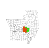
Central city Largest cities
(over 20,000 in 2000)Affton CDP · Alton · Ballwin · Belleville · Chesterfield · Collinsville · East St. Louis · Edwardsville · Ferguson · Florissant · Granite City · Hazelwood · Kirkwood · Maryland Heights · Mehlville CDP · Oakville CDP · O'Fallon, Illinois · O'Fallon, Missouri · Saint Charles · St. Peters · Spanish Lake CDP · University City · Webster Groves · WildwoodLargest towns
and villages
(over 10,000 in 2000)Arnold · Bellefontaine Neighbors · Berkeley · Bridgeton · Cahokia · Clayton · Concord CDP · Crestwood · Creve Coeur · Fairview Heights · Farmington · Festus · Glen Carbon · Godfrey · Jennings · Lake St. Louis · Lemay CDP · Manchester · Overland · St. Ann · Swansea · Town and Country · Washington · Wentzville · Wood RiverMissouri Counties Franklin · Jefferson · Lincoln · St. Charles · Saint Francois · St. Louis City · St. Louis County · Warren · WashingtonIllinois Counties Subregions Categories:- Census-designated places in St. Louis County, Missouri
- Census-designated places in Missouri


Wikimedia Foundation. 2010.