- Washington State Route 165
infobox WA State Route
type=WA
route=165
sec=325
parent=410
parent_type=WA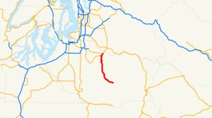
length_mi=21.25
from=Mount Rainier National Park nearMowich Lake
to=jct|state=WA|SR|410 in Buckley
length_ref=cite web|author=Washington State Department of Transportation |url=http://www.wsdot.wa.gov/mapsdata/TDO/PDF_and_ZIP_Files/HwyLog2006.pdf|title=State Highway Log|date=2006|accessdate=2008-04-10]
length_round=2
dir1=South
dir2=North
previous_type=SR
previous_route=164
next_type=SR
next_route=166State Route 165 is a numbered state highway in
Washington ,United States . Its northern terminus is at State Route 410 in Buckley. Its southern terminus is at theMount Rainier National Park boundary nearMowich Lake .Route description
The road begins at an intersection with State Route 410 in Buckley. It heads south, intersects with State Route 162 and then passes through the towns of Wilkeson and Carbonado. [cite map |publisher=Rand McNally |title=The Road Atlas |year=2006 |page=108 |section=H8 |isbn=0528957902] South of Carbonado, the road forks. The north fork goes to the
Carbon River entrance toMount Rainier National Park , while SR 165 continues along the south fork (Mowich Lake Road) intoMount Rainier National Park . [cite map |publisher=Yahoo! Maps |title=Carbonado, WA|url=http://maps.yahoo.com/;_ylc=X3oDMTExNmIycG51BF9TAzI3MTYxNDkEc2VjA2ZwLWJ1dHRvbgRzbGsDbGluaw--#mvt=m&lat=47.033676&lon=-122.038434&zoom=15&q1=carbonado%2C%20wa |year=2008 |cartography=NAVTEQ |accessdate=2008-04-12 ]State maintenance (along with the State Route 165 designation) ends at the park boundary. Mowich Lake Road continues 6 miles (9 km) into the park, ending at ranger station at
Mowich Lake . The road inside the park is only open from July to October each year due to winter conditions. [cite map|publisher=National Park Service |title=Mount Rainier National Park|url=http://www.nps.gov/mora/planyourvisit/upload/MORAmap5_07reduced.pdf|accessdate=2008-04-12]History
State Route 165 was added to the state highway system in 1931 as a part of State Road 5. [Session Laws of the State of Washington. 1931 chapter 29.] In 1937, this was renamed Primary State Highway 5, and what is now SR 165 was the Enumclaw-Fairfax branch of that highway (except between Enumclaw and Buckley, which is now SR 410). When the current highway numbering system was developed with the 1964 renumbering, the highway became State Route 165. [cite web|author=
Washington State Highway Commission |url=http://www.wsdot.wa.gov/NR/rdonlyres/6836215D-E301-43F3-895A-472BD2FDE86A/0/Identification.pdf|title=Identification of State Highways|date=December 1 ,1965 |accessdate=2008-04-10]Major intersections
References

Wikimedia Foundation. 2010.