- Chilton Polden
-
Coordinates: 51°09′11″N 2°53′46″W / 51.153°N 2.896°W
Chilton Polden 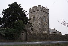
Chilton Priory
 Chilton Polden
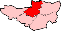
Chilton Polden shown within SomersetPopulation 678 [1] OS grid reference ST374396 District Sedgemoor Shire county Somerset Region South West Country England Sovereign state United Kingdom Post town BRIDGWATER Postcode district TA7 Dialling code 01278 Police Avon and Somerset Fire Devon and Somerset Ambulance South Western EU Parliament South West England UK Parliament Bridgwater and West Somerset List of places: UK • England • Somerset Chilton Polden is a rural village and civil parish, situated close to Edington on the Somerset Levels to the north of the Polden Hills in the Sedgemoor district of Somerset, England.
Contents
History
The name of the village is thought to derive from its position on limestone and from the hill on which part of the parish lies. The form Chelton upon Poledowne is found in 1664.[2] The Polden estate was given to Glastonbury Abbey by Æthelheard of Wessex in 729.
Chilton Priory (also known as Stradling's Folly) was originally built as a folly, and subsequently enlarged to become a country house. The tower and wing at the rear were built in 1838, for William Stradling.[3] Stradling also incorporated various pieces of buildings and archaeological relics from around the county, especially materials from a Roman Villa at Chedzoy. The upper windows, battlements and grotesque heads came from a demolished castle at Enmore and the pinnacles from an old church tower at Langport. The staircase turret came from a church in Shepton Mallet and three of the windows in the nave from a chapel at Slapeland.[4] The Priory has more recently been home to Katherine Maltwood who was an artist and became known as the discoverer of the Glastonbury Zodiac (otherwise known as the Temple of the Stars), an enormous geomantic creation surrounding the Tor at Glastonbury. The Temple was another folly tower, built by Stradling in the early 19th incorporating re-used 15th features.[5]
Governance
The parish council has responsibility for local issues, including setting an annual precept (local rate) to cover the council’s operating costs and producing annual accounts for public scrutiny. The parish council evaluates local planning applications and works with the local police, district council officers, and neighbourhood watch groups on matters of crime, security, and traffic. The parish council's role also includes initiating projects for the maintenance and repair of parish facilities, as well as consulting with the district council on the maintenance, repair, and improvement of highways, drainage, footpaths, public transport, and street cleaning. Conservation matters (including trees and listed buildings) and environmental issues are also the responsibility of the council.
The village falls within the Non-metropolitan district of Sedgemoor, which was formed on 1 April 1974 under the Local Government Act 1972, having previously been part of Bridgwater Rural District,[6] which is responsible for local planning and building control, local roads, council housing, environmental health, markets and fairs, refuse collection and recycling, cemeteries and crematoria, leisure services, parks, and tourism.
Somerset County Council is responsible for running the largest and most expensive local services such as education, social services, libraries, main roads, public transport, policing and fire services, trading standards, waste disposal and strategic planning.
It is also part of the Bridgwater and West Somerset county constituency represented in the House of Commons of the Parliament of the United Kingdom. It elects one Member of Parliament (MP) by the first past the post system of election, and part of the South West England constituency of the European Parliament which elects seven MEPs using the d'Hondt method of party-list proportional representation.
Geography
Catcott, Edington and Chilton Moors SSSI is a 1083 hectare biological Site of Special Scientific Interest consisting of land south of the River Brue managed by Somerset Wildlife Trust and is known for the variety of the bird life. The site consists of low lying land south of the River Brue, which floods on a regular basis; land north is included in the Tealham and Tadham Moors SSSI. The site is managed by Somerset Wildlife Trust and includes the Catcott Lows National Nature Reserve, of grassland in the summer, but flood during the winter, creating a perfect habitat for wintering waterfowl and Bewick's Swans,[7] Roe Deer and several invertebrate species of scientific interest also inhabit the area,[8][9] Catcott Heath[10] and Catcott North.[11]
Religious sites
The Anglican parish Church of St Edward has 15th century origins and was rebuilt in 1889 by Henry Edwards.[12] The Parish Room in the churchyard dates from the 14th century.[13]
References
- ^ "Parish Population Statistics for Sedgemoor". ONS Census 2001. Somerset County Council. http://www.webcitation.org/5lRyCSu4c. Retrieved 2009-12-17.
- ^ "Chilton Polden". British History Online. http://www.british-history.ac.uk/report.aspx?compid=15105. Retrieved 2007-12-02.
- ^ "Chilton Priory". Images of England. English Heritage. http://www.imagesofengland.org.uk/Details/Default.aspx?id=269457. Retrieved 2008-12-15.
- ^ Holt, Jonathan. Somerset Follies. Bath: Akeman Press. pp. 63–64. ISBN 9780954613877.
- ^ "The Temple". Images of England. English Heritage. http://www.imagesofengland.org.uk/Details/Default.aspx?id=269460. Retrieved 2008-12-15.
- ^ A Vision of Britain Through Time : Bridgwater Rural District
- ^ "Catcott Lows". Somerset Wildlife Trust. http://www.somersetwildlife.org/reserveview.php?id=53. Retrieved 3 December 2008.
- ^ English Nature citation sheet for the site . Retrieved 6 August 2006.
- ^ Brown, Alan. "Catcott Lows NNR". Avalon Marshes Reserve Guides. http://www.glastonbury.eclipse.co.uk/web_site_with_me_00009f.htm. Retrieved 2008-10-18.
- ^ "Catcott Heath". Somerset Wildlife Trust. http://www.somersetwildlife.org/reserveview.php?id=3. Retrieved 2008-10-18.
- ^ "Catcott North". Somerset Wildlife Trust. http://www.somersetwildlife.org/reserveview.php?id=20. Retrieved 2008-10-18.
- ^ "Church of St Edward". Images of England. English Heritage. http://www.imagesofengland.org.uk/Details/Default.aspx?id=269465. Retrieved 2008-12-15.
- ^ "Parish Room in the churchyard". Images of England. English Heritage. http://www.imagesofengland.org.uk/Details/Default.aspx?id=269466. Retrieved 2008-12-15.
Towns, villages and hamlets in the Sedgemoor district of Somerset, England  Ashcott · Axbridge · Badgworth · Bawdrip · Berrow · Brean · Brent Knoll · Bridgwater · Broomfield · Burnham-on-Sea · Burtle · Cannington · Catcott · Chapel Allerton · Cheddar · Chedzoy · Chilton Polden · Chilton Trinity · Compton Bishop · Cossington · Durleigh · East Brent · Huntspill · Edington · Edithmead · Enmore · Fiddington · Goathurst · Greinton · Highbridge · Lympsham · Lyng · Mark · Middlezoy · Moorlinch · Nether Stowey · North Petherton · Othery · Otterhampton · Over Stowey · Pawlett · Puriton · Shapwick · Shipham · Spaxton · Stawell · Stockland Bristol · Thurloxton · Weare · Wedmore · Wembdon · Westonzoyland · WoolavingtonCategories:
- Villages in Sedgemoor
- Somerset Levels
- Civil parishes in Somerset


Wikimedia Foundation. 2010.