- Culbertson, Montana
-
Culbertson, Montana — Town — Location of Culbertson, Montana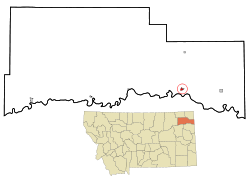
Coordinates: 48°8′50″N 104°31′2″W / 48.14722°N 104.51722°WCoordinates: 48°8′50″N 104°31′2″W / 48.14722°N 104.51722°W Country United States State Montana County Roosevelt Elevation 1,932 ft (589 m) Population (2010)[1] – Total 714 Time zone Mountain (MST) (UTC-7) – Summer (DST) MDT (UTC-6) ZIP code 59218 Area code(s) 406 FIPS code 30-18475 GNIS feature ID 0770366 Culbertson is a town in Roosevelt County, Montana, United States. The population was 714 at the 2010 census.[1]
Contents
History
Culbertson was created in June 1887 following the arrival of the Great Northern Railway, then known as the St. Paul, Minneapolis & Manitoba Railway. The town was named after Major Alexander Culbertson, former head of the American Fur Company's Fort Union 23 miles (37 km) to the west.[2]
The settlement of Culbertson followed hard on the heels of the 1886-87 watershed years for the early cattle industry. As a result, the first settlers in the area raised horses for the US Cavalry’s various Montana and Dakota posts. As cattle prices slowly rebounded, the range was once again stocked with cattle, though the second wave of cattlemen utilized hardy English breeds instead of the Texas longhorns of the earlier outfits.[3]
With the passage of new homestead laws in 1909 enabling homesteaders to take out larger acreages, the area saw an influx of dryland farmers. With its railroad connection, Culbertson became the center of the area’s agricultural trade. When the agricultural boom went bust after World War II and never resumed its former glory, Culbertson saw a gradual decline in businesses and population. This was somewhat ameliorated by a heavy railroad presence in the community.
Culbertson also became a surviving center as smaller adjacent communities dried up in the agricultural depression of the 1920s and 1930s. With better automobiles and better roads, farmers and ranchers could live further from centers of trade.
Demographics
Historical populations Census Pop. %± 1910 528 — 1920 547 3.6% 1930 536 −2.0% 1940 585 9.1% 1950 779 33.2% 1960 919 18.0% 1970 821 −10.7% 1980 887 8.0% 1990 796 −10.3% 2000 716 −10.1% 2010 714 −0.3% U.S. Decennial Census As of the census[4] of 2000, there were 716 people, 295 households, and 192 families residing in the town. The population density was 1,213.7 people per square mile (468.6/km²). There were 356 housing units at an average density of 603.5 per square mile (233.0/km²). The racial makeup of the town was 89.53% White, 0.28% African American, 6.01% Native American, 0.28% Asian, 0.84% from other races, and 3.07% from two or more races. Hispanic or Latino of any race were 0.98% of the population.
There were 295 households out of which 32.5% had children under the age of 18 living with them, 55.6% were married couples living together, 6.4% had a female householder with no husband present, and 34.6% were non-families. 30.8% of all households were made up of individuals and 15.6% had someone living alone who was 65 years of age or older. The average household size was 2.32 and the average family size was 2.90.
In the town the population was spread out with 23.7% under the age of 18, 5.4% from 18 to 24, 23.7% from 25 to 44, 24.0% from 45 to 64, and 23.0% who were 65 years of age or older. The median age was 43 years. For every 100 females there were 89.9 males. For every 100 females age 18 and over, there were 90.9 males.
The median income for a household in the town was $30,000, and the median income for a family was $38,750. Males had a median income of $26,771 versus $14,643 for females. The per capita income for the town was $15,393. About 11.2% of families and 11.3% of the population were below the poverty line, including 8.6% of those under age 18 and 14.9% of those age 65 or over.
Notable residents
- Lane Chandler, western film actor, lived here as a child.
References
- ^ a b "2010 Census Redistricting Data (Public Law 94-171) Summary File". American FactFinder. United States Census Bureau. http://factfinder2.census.gov/faces/tableservices/jsf/pages/productview.xhtml?pid=DEC_10_PL_GCTPL2.ST13&prodType=table. Retrieved 2 May 2011.
- ^ "Montana Place Names Companion". Montana Place Names From Alzada to Zortman. Montana Historical Society Research Center. http://mtplacenames.org/. Retrieved 9 May 2011.
- ^ Malone, Michael P.; Richard B. Roeder and William L. Lang (1991). Montana, A History of Two Centuries. Seattle and London: University of Washington Press.
- ^ "American FactFinder". United States Census Bureau. http://factfinder.census.gov. Retrieved 2008-01-31.
Municipalities and communities of Roosevelt County, Montana Cities 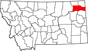
Towns Indian reservations Ghost town Footnotes ‡This populated place also has portions in an adjacent county or counties
Categories:- Populated places in Roosevelt County, Montana
- Towns in Montana
- Montana populated places on the Missouri River


Wikimedia Foundation. 2010.