- Ditchling
-
Coordinates: 50°55′N 0°07′W / 50.92°N 0.11°W
Ditchling 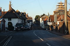
 Ditchling
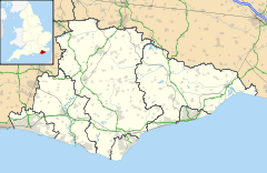
Ditchling shown within East SussexArea 15.49 km2 (5.98 sq mi) [1] Population 2,027 (2007)[1]
1,802 (2001 Census)- Density 339 /sq mi (131 /km2) OS grid reference TQ325151 - London 37 miles (60 km) N District Lewes Shire county East Sussex Region South East Country England Sovereign state United Kingdom Post town HASSOCKS Postcode district BN6 Dialling code 01273 Police Sussex Fire East Sussex Ambulance South East Coast EU Parliament South East England UK Parliament Lewes List of places: UK • England • East Sussex Ditchling is a village and civil parish in the Lewes District of East Sussex, England. The village is contained within the boundaries of the South Downs National Park; the order confirming the establishment of the park was signed in Ditchling.[2]
An artistic community founded by the artist Eric Gill during the early 20th century, and known as The Guild of St Joseph and St Dominic[3] survived until 1989.
Contents
Location
The village lies at the foot of the South Downs in East Sussex, but very close to the border with West Sussex. The settlement stands around a crossroads with Brighton to the south, Burgess Hill and Haywards Heath to the north, Keymer and Hassocks to the west, and Lewes to the east, and is built on a slight spur of land between the Downs to the south and Lodge Hill to the north. Ditchling Beacon, one of the highest points on the South Downs, overlooks the village.
Ditchling Common, north of the village, is the source of the eastern River Adur which meets with the western River Adur near Henfield and flows on to the English Channel at Shoreham-by-Sea.[4]
History
The history of Ditchling starts properly in Saxon times [5], when the people of Dicul settled here and King Alfred the Great held lands as a Royal Manor.
It is unknown exactly when the people of Dicul settled in the village, but Ditchling is first recorded in 765 as Dicelinga in a grant by King Alduuf of land bordering that of Ditchling[citation needed]. Later it is recorded that the Manor and its lands were held by King Alfred. When Alfred died in the year 900 it was given to a kinsmen named Osferth, and then reverted to the Crown under Edward the Confessor. After the Norman conquest, the land was held by William de Warenne. The Domesday book mentions a church and a mill in Ditchling and the population was approx 150 households. The land passed through several hands until in 1435 it was owned by the Marquess of Abergavenny who held it until the 20th century, when it was sold to developers who failed to get planning permission to build.
In the 18th and 19th centuries the Old Meeting House in Ditchling was an important centre for Baptists from the wider area, whose records and memorandum books allow a unique insight into a small rural religious community of the period. These records (in the East Sussex Record Office) bear witness to often fractious and heated debates about morality and religion.
In January 2007, Ditchling featured in a five piece BBC Documentary entitled Storyville: A Very English Village. This was filmed, produced and directed by a Ditchling resident, but the series itself came under criticism from local residents.
Ditchling has a number of establishments to offer its residents and visitors to the village. These consist of two public houses, The Bull and The White Horse and the cafe/eatery Ditchling Tea Rooms (previously known as Dolly's Pantry). It has a two local shops - The General (Renamed from Chestertons in 2010) and Parker's newsagent in addition to a small selection of other retail outlets selling jewellery, antiques and artwork.
Landmarks
There are two Sites of Special Scientific Interest within the parish of Ditchling. Ditchling Common is of biological interest because of the variety of heath grassland habitats, created by the different drainage conditions throughout the common.[6] The second site is Clayton to Offham Escarpment, which stretches from Hassocks in the west, passing through many parishes including Ditchling, to Lewes in the East. This site is of biological importance due to its rare chalk grassland habitat along with its woodland and scrub.[7]
The Guild of St Joseph and St Dominic
Main article: The Guild of St Joseph and St DominicEric Gill, the sculptor and letter cutter, came to Ditchling in 1907 with his apprentice Joseph Cribb and was soon followed by other craftsmen. In 1921 they founded the Guild of St Joseph and St Dominic, a Roman Catholic community of artists and craftsmen, inspired by ideas of the medieval guilds and the Arts and Crafts movement. The community had its own workshops and chapel, and thrived for many years. Its affairs were finally wound up in 1989, and the workshops demolished.
Education
There is one school in Ditchling, Ditchling (St Margaret's) Church of England Primary School. This is a voluntary controlled primary school for children aged 4–11. Many of the children after leaving this school go to Downlands Community School in the village of Hassocks located in the adjoining county of West Sussex.
Religious buildings
 The Old Meeting House of 1740 is used by Unitarians.
 See also: List of places of worship in Lewes (district)
Ditchling has a long history of Protestant Nonconformism.[8] The village has four extant places of Christian worship and one former chapel. St Margaret's Church, founded in the 11th century, is the village's Anglican church. The fabric of the flint and sandstone building is mostly 13th-century, although the nave is original.[8][9] In 1740, a chapel (now called The Old Meeting House) was built on the side of a late 17th-century house off East End Lane. It is now used by the Unitarian community.[9][10] Emmanuel Chapel, used by an Evangelical congregation, was built in the early 20th century but may have had a predecessor elsewhere in the village.[8][9] The Quaker community have a modern meeting house near the centre of the village.[11][12] The Beulah Strict Baptist Chapel (now a house) on East End Lane was in religious use between 1867 and the 1930s.[8][10]
Notable residents (past and present)
- Sir Frank Brangwyn
- Raymond Briggs
- S. F. Edge
- Herbie Flowers
- Eric Gill
- Peter James
- Edward Johnston
- David Jones
- John Vernon Lord
- Dame Vera Lynn
- Hilary Pepler
- Brocard Sewell
- Sir Donald Sinden
- Jamie Theakston
- Len Howard
References
- ^ a b "East Sussex in Figures". East Sussex County Council. http://www.eastsussexinfigures.org.uk/webview/. Retrieved 26 April 2008.
- ^ "National Park is Confirmed". South Downs Society. http://www.southdownssociety.org.uk/do/ecco/view_item?listid=35&listcatid=147&listitemid=1585.
- ^ S Y N T H E S I S — The Guild Of St. Joseph And St. Dominic
- ^ Information About River Adur | Canals & Rivers | Waterscape.com
- ^ Ditchling
- ^ "Natural England — SSSI (Ditchling Common)". English Nature. http://www.english-nature.org.uk/special/sssi/sssi_details.cfm?sssi_id=1002188. Retrieved 5 October 2008.
- ^ "Natural England — SSSI (Clayton to Offham Escarpment)". English Nature. http://www.english-nature.org.uk/special/sssi/sssi_details.cfm?sssi_id=1002124. Retrieved 5 October 2008.
- ^ a b c d Salzman, L. F. (ed) (1940). "A History of the County of Sussex: Volume 7. Parishes: Ditchling". Victoria County History of Sussex. British History Online. pp. 102–109. https://www.british-history.ac.uk/report.aspx?compid=56929. Retrieved 7 April 2010.
- ^ a b c Harris, Roland B. (June 2005). "Ditchling Historic Character Assessment" (PDF). Sussex Extensive Urban Survey (EUS). East Sussex County Council, West Sussex County Council, Brighton and Hove City Council and English Heritage. http://www.lewes.gov.uk/Files/plan_Ditchling_EUS_reportpg1to17.pdf. Retrieved 7 April 2010.
- ^ a b Elleray, D. Robert (2004). Sussex Places of Worship. Worthing: Optimus Books. p. 19. ISBN 0-95-331-3271.
- ^ "Ditchling Conservation Area Character Appraisal" (PDF). Lewes District Council (Planning and Environmental Services Department). April 2007. http://www.lewes.gov.uk/Files/plan_CAA_Ditchlingpages1to9.pdf. Retrieved 7 April 2010.
- ^ "Ditchling Quaker Meeting". Ditchling Quakers website. Ditchling Quaker Meeting. 2009. http://ditchlingquakers.org.uk/. Retrieved 7 April 2010.
External links
Towns Lewes · Newhaven · Peacehaven · Telscombe · Seaford
Villages / hamlets Barcombe · Barcombe Cross · Barcombe Mills · Beddingham · Bishopstone · Chailey · Denton · Ditchling · East Blatchington · East Chiltington · Falmer · Firle · Glynde · Hamsey · Iford · Kingston near Lewes · Newick · North Chailey · Piddinghoe · Plumpton · Plumpton Green · Ringmer · Rodmell · Spithurst · South Heighton · Southease · St Ann Without · St John Without · South Chailey · South Street · Streat · Tarring Neville · Telscombe Cliffs · Town Littleworth · Westmeston · Wivelsfield · Wivelsfield Green
Other areas List of civil parishes in Lewes District Categories:- Lewes
- Villages in East Sussex
- Local government in East Sussex


Wikimedia Foundation. 2010.