- Dunnet
-
For the Emacs based text adventure computer game, see Dunnet (game).Not to be confused with Dunnett.
Coordinates: 58°37′N 3°20′W / 58.62°N 3.34°W
Dunnet Scottish Gaelic: Dùnaid 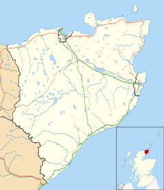
 Dunnet
Dunnet shown within the Caithness areaOS grid reference ND221713 Council area Highland Lieutenancy area Caithness Country Scotland Sovereign state United Kingdom Post town THURSO Postcode district KW14 Dialling code 01847 Police Northern Fire Highlands and Islands Ambulance Scottish EU Parliament Scotland UK Parliament Caithness, Sutherland and Easter Ross Scottish Parliament Caithness, Sutherland and Easter Ross constituency in the Highlands and Islands electoral region List of places: UK • Scotland • Dunnet ) is a village in Caithness, in the Highland area of Scotland. It is within the Parish of Dunnet.
 Mary Anne's Cottage Museum, a museum of crofting life, in West Dunnet
The village centres on the A836–B855 road junction. The A836 leads towards John o' Groats in the east and toward Thurso and Tongue in the west. (At the junction however the road's alignment is much more north-south than east-west.) The B855 leads toward Brough and Dunnet Head point in the north.
The Northern Sands Hotel is located on the A836, adjacent to the village church. It is a small, family-run hotel with 12 bedrooms, a large dining room, a large car park & 2 bars. It was originally called The Golf Links Hotel, there being a links course between Dunnet & Castletown that fell into disuse during World War II. It is locally owned.
The village has a hall, The Britannia Hall, which is run by a committee, it is used for a variety of activities including a children's nursery, an indoor bowling club, a badminton club & the Post Office visits twice a week, on Wednesday afternoons & Saturdays. Its main fund raising activity each year for the upkeep of the hall is the Marymas Fair, held in late August on a nearby farm field, it has the usual attractions such as Highland Dancing, a display of vintage & classic cars & motorcycles, bonniest baby, home baking, tossing the wheatsheaf, line dancing, face painting, raffles and tug of war.
The House of the Northern Gate (sometimes called Dwarick House) sits in a commanding position on Dunnet head, overlooking the west side of the village. It is thought to have been built by the Sinclairs of Freswick, who owned a great deal of the village historically. It was later owned by Admiral North, then from the 1930s to the late '50s, by Commander Clair Vyner & his wife Lady Doris Vyner. They used it as a summer residence & ran the local salmon station. Lady Vyner was a close friend of HM Queen Elizabeth the Queen Mother & invited her to stay at the house in 1953. During her stay, she looked east out of one of the upper floor windows & spied the tower of the recently-vacated Barrogill Castle, 3 miles (4.8 km) away. Upon enquiring about the castle, a visit was arranged to view it, it was owned by Mr & Mrs Imbert-Terry, an eccentric couple whose family reputedly owned Terry's chocolate factory in York. A deal was struck to buy the rather dilapidated castle & Longoe Mains farm for a reported £6,000. The Queen Mother renamed it the Castle of Mey, its original name. The House of the Northern Gate was made into a hotel by Bill Dodd in the '60s & owned by a Mr Divanian Gold in the '70s, a flamboyant Jewish fashon clothes manufacturer from Manchester, who used it as a summer home. He later tried to sell building plots on its land, but the council vetoed the project on grounds of drainage & sewerage difficulties, because the land is flow country or blanket bog. In the late '70s it came on the market again & the rock band Led Zeppelin viewed it several times with a view to making it into a recording studio, a possible reason for this is the fact that guitarist Jimmy Page already owned Boleskin House, for many years the home of notorious occultist & white witch Aleister Crowley, near Foyers on the south bank of Loch Ness & was a frequent visitor to Caithness. Also Woody, of the band The Bay City Rollers looked into buying the house as a country retreat, his Uncle worked at Dounreay at the time & Woody was a frequent visitor to Caithness in the mid-70's. During this period, scenes from a horror film were recorded using the outside of the house as a backdrop. The house was empty until the mid-'80s, when a family from Kent bought it & made it into a private residence again. It has 1,800 acres (7.3 km2) of land, 2 lochs, a small pier & a small beach, "The Peedie Sannie" (The small beach).
Dunnet Church is near the road junction and has documented history dating from 1230.
CH Haygarth & Sons, Gun & Rifle Makers, are situated on the A836 on the eastern side of the Village, they are Scotland's oldest practicing gunmakers & cartridge loaders & the only full-time gunshop North of Inverness & are unusual in that it is still family owned & run by Colin's 2nd son, Ross, marking the business's 3rd generation of ownership by the Haygarth Clan. They were the Queen Mother's gunsmiths from 1964 until her death in 2001. The building was the site of the original village shop, owned by the Begg family, which closed in the mid-1950s. The property was built in 1900.
Dunnet is at the north/northeast end of Dunnet Beach, which extends across three miles (5 km) towards Castletown (ND196678).
Dunnet Forest (ND226701) is south of the village and east of the here southward A836.
St John's Loch (ND226722), known also as Dunnet Loch, is north-east of the village.
Archaeology
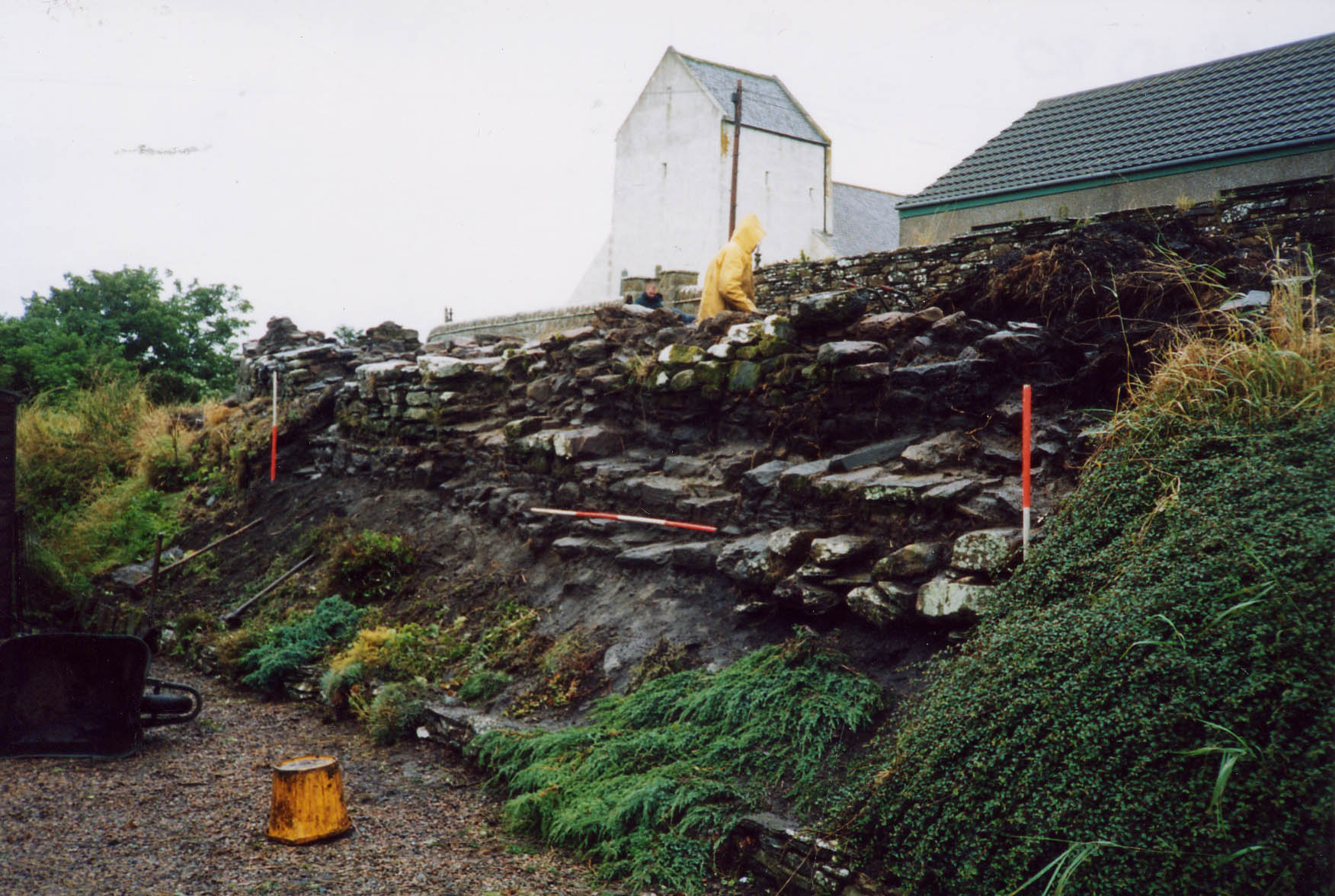
Brotchie’s steading, is a ruined croft house just to the West of Dunnet Church.[1] It originally became the focus of archaeological interest because structural members (cruck blades) in one of the rooms were known to have been formed from a pair of whale mandibles, probably from a fin or blue whale. These are presently housed in the Dunnet Bay Visitor Centre.
An excavation by Headland Archaeology was undertaken to examine the role of whale bones as a construction material in Caithness croft houses but it quickly became apparent that the 19th/20th century croft house sits on a much older and extensive archaeological site.
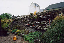 Brotchie's steading facing NE showing the depth of stratigraphy
Trial trenching has shown that the bank upon which Brotchie’s steading sits is largely man-made and part of an extensive settlement mound that possibly includes a ruined broch. The earliest deposits excavated were from an occupation surface and material from this provided a date in the range 390-170 BC. At the North end of the site a thick layer of stone rubble associated with a clay and stone-lined pit and two red deer antler picks was identified. Radiocarbon dating showed these to be from the 1st-3rd centuries AD The overlying strata supported by a sequence of radiocarbon dates and datable finds indicate that the site was also a focus of human activity in the 5th, 13th and 15th centuries up until the early 20th century. While the full extent of the site is currently unknown the knoll upon which Dunnet Church now sits would appear to form a part of a major archaeological site that has seen almost continuous, or at least regular, occupation for over two millennia.[2]
References
- ^ Dunnet, Kirkstyle, Brotchie's Steading. Royal Commission on the Ancient and Historical Monuments of Scotland
- ^ Holden, T 2003 'Brotchie's Steading (Dunnet parish), iron age and medieval settlement; post-medieval farm', Discovery Excav Scot, 4, 2003, 85-6.
Categories:- Populated places in Caithness


Wikimedia Foundation. 2010.