- Dietikon
-
Dietikon 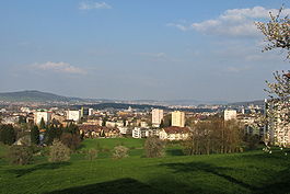
Country Switzerland 
Canton Zurich District Dietikon 47°24′N 8°24′E / 47.4°N 8.4°ECoordinates: 47°24′N 8°24′E / 47.4°N 8.4°E Population 23,578 (Dec 2010)[1] - Density 2,527 /km2 (6,545 /sq mi) Area 9.33 km2 (3.60 sq mi) Elevation 388 m (1,273 ft) Postal code 8953 SFOS number 0243 Surrounded by Bergdietikon (AG), Geroldswil, Oetwil an der Limmat, Schlieren, Spreitenbach (AG), Unterengstringen, Urdorf, Weiningen Twin towns Kolin (Czech Republic), Braggio (Switzerland), Renens (Switzerland) Website www.dietikon.ch
SFSO statistics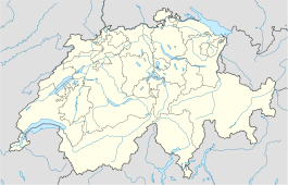
 Dietikon
View map of Dietikon Dietikon is the fifth biggest city of the canton of Zürich in Switzerland, after Zürich, Winterthur, Uster and Dübendorf. It is the capital of the same-named district of Dietikon and part of the Zürich metropolitan area.
Contents
Geography

 Limmat river at Dietikon train station
The industrial city Dietikon is situated at an altitude of 388 m (1,273 ft) at the confluence of the Reppisch and Limmat rivers, located in the Limmat Valley (German: Limmattal), along the railway line from Zürich to Baden. Here and in the neighboring region, Spreitenbach, is also the large rail freight marshalling yard Limmattal.
Dietikon has an area of 9.3 square kilometers (3.6 sq mi). Of this area, 17.2% is used for agricultural purposes, while 27% is forested. Of the rest of the land, 49.1% is settled (buildings or roads) and the remainder (6.7%) is non-productive (rivers, glaciers or mountains).[2] In 1996[update] housing and buildings made up 33.8% of the total area, while transportation infrastructure made up the rest (15.3%).[3] Of the total unproductive area, water (streams and lakes) made up 4.9% of the area. As of 2007[update] 40.7% of the total municipal area was undergoing some type of construction.[3]
The largest and best known forests of the municipality include the Honeret, Guggenbüehl and Röhrenmoos.
The Honeret forest lies on a side moraine of the Linth glacier ("Linthgletscher"). There are over 200 prominent stones therefrom up to foundling boulders as big as 25 m2 (270 sq ft). The Honeret and the Guggenbüehl-Wald are separated by only one main street. In the forest, there are a few sources that form the brooks Tobelbach and Stoffelbach and flow into the Reppisch afterwards. Also in the forest lies the forest cottage "Lorenzhütte."
The Guggenbüehl forest lies completely in Dietikon. In the forest, the pond "Giigelibode" lies. It has neither influx nor drains. A Vita course is in the forest.
Transportation
 S17 line provided by the Bremgarten-Dietikon-Bahn
 Marmoriweiher pond alongside the Reppisch river
The municipality is located on the A3 motorway.
Dietikon and Glanzenberg are stops of the S-Bahn Zürich on the lines S3 and S12. Dietikon is a terminal station on the line S17 provided by the Bremgarten-Dietikon-Bahn.
Waters
Important running waters that flow through Dietikon are the Limmat river and its tributary Reppisch. Wide brooks are the approximately 3 km (1.9 mi) long Schäflibach and the Teischlibach. The Schäflibach is created with the flows together from Allmendbach and Stockacherbach and leads into the Limmat. The Teischlibach originates from Röhrenmoos in the forest above Dietikon and also leads into the Limmat. The Marmoriweiher lies in the Grunschen a place used for gaming and grilling. The Marmoriweiher is an artificial pond, that was positioned for the water supply of the fire brigade. For this, a distraction canal was built with the Grunschen. Later, the pond of a marble factory served. This gave it its name.
History
Dietikon is first mentioned in 1100 as Dietinchovin.[4] In Dietikon there are several Roman ruins and also the Fahr Benedictine Convent, given by the Lords of Regensberg around 1130 AD, with a cloister church dating from the years 1743 to 1746. The Second Battle of Zürich was fought in Dietikon (September 1799) and the town name is now inscribed at the pillar of the Arc de Triomphe in Paris, France.
Politics
City president is an Otto Müller (FDP).
Demographics
 Town hall in Dietikon
 The classification yard RBL (Rangierbahnhof Limmattal)
 St. Agatha, the Roman Catholic Church (built in 1927)
 The Reformed church (built in 1925)
Dietikon has a population (as of 31 December 2010) of 23,578.[1] As of 2007[update], 39.8% of the population was made up of foreign nationals. As of 2008[update] the gender distribution of the population was 50% male and 50% female. Over the last 10 years the population has grown at a rate of 10.5%. Most of the population (as of 2000[update]) speaks German (73.9%), with Italian being second most common ( 8.9%) and Albanian being third ( 3.8%).
In the 2007 election the most popular party was the SVP which received 40.1% of the vote. The next three most popular parties were the SPS (19.9%), the CVP (13.7%) and the FDP (8%).
The age distribution of the population (as of 2000[update]) is children and teenagers (0–19 years old) make up 21.3% of the population, while adults (20–64 years old) make up 64.7% and seniors (over 64 years old) make up 14%. The entire Swiss population is generally well educated. In Dietikon about 60.1% of the population (between age 25-64) have completed either non-mandatory upper secondary education or additional higher education (either university or a Fachhochschule). There are 9892 households in Dietikon.[3]
Dietikon has an unemployment rate of 4.2%. As of 2005[update], there were 179 people employed in the primary economic sector and about 13 businesses involved in this sector. 2613 people are employed in the secondary sector and there are 213 businesses in this sector. 10632 people are employed in the tertiary sector, with 957 businesses in this sector.[2] As of 2007[update] 60.6% of the working population were employed full-time, and 39.4% were employed part-time.[3]
As of 2008[update] there were 8655 Catholics and 4599 Protestants in Dietikon. In the 2000 census[update], religion was broken down into several smaller categories. From the 2000 census, 26.5% were some type of Protestant, with 24.6% belonging to the Swiss Reformed Church and 1.9% belonging to other Protestant churches. 41.8% of the population were Catholic. Of the rest of the population, 12.2% were Muslim, 16.1% belonged to another religion (not listed), 4.6% did not give a religion, and 9.4% were atheist or agnostic.[3]
The historical population is given in the following table:[4]
year population 1779 686 1836 1,025 1850 1,291 1900 2,613 1910 4,493 1950 7,132 1960 14,920 1970 22,705 1990 21,152 2000 21,353 Weather
Dietikon has an average of 132.2 days of rain per year and on average receives 1,078 mm (42.4 in) of precipitation. The wettest month is August during which time Dietikon receives an average of 114 mm (4.5 in) of precipitation. During the wettest month, there is precipitation for an average of 12.7 days.[5]
Personalities
- Bruno Weber (* 10. April 1931), architect and sculptor
- Markus Notter (* 21. November 1960), politician and former city president
Gallery
-

Zentralschulhaus building
-

Zürcherstrasse towards Schlieren
-

Protected area Dietiker & Geroldswiler Auen on the Limmat river's shore
-

Hiking path at Glanzenberg train station
-

Ruins of the Schönenwerd water castle
-

Dietikon as part of the inscription at the Arc de Triomphe in Paris referring to the Second Battle of Zürich in 1799
-

Bruno Weber's Skulpturenpark
-

Earth house estate Lättenstrasse by Peter Vetsch
References
- ^ a b Canton of Zurich Statistical Office (German) accessed 29 March 2011
- ^ a b Swiss Federal Statistical Office accessed 05-Aug-2009
- ^ a b c d e Statistics Zurich (German) accessed 4 August 2009
- ^ a b Dietikon in German, French and Italian in the online Historical Dictionary of Switzerland.
- ^ "Temperature and Precipitation Average Values-Table, 1961-1990" (in German, French, Italian). Federal Office of Meteorology and Climatology - MeteoSwiss. http://www.meteoswiss.admin.ch/web/de/klima/klima_schweiz/tabellen.html. Retrieved 8 May 2009., the weather station elevation is 385 meters above sea level.
External links
- Official website (German)
- Dietikon in German, French and Italian in the online Historical Dictionary of Switzerland.
 Categories:
- Municipalities of the canton of Zurich
- Municipalities of Switzerland
- Cities in Switzerland


Wikimedia Foundation. 2010.