- Coon Rapids, Minnesota
-
Coon Rapids, Minnesota — City — Logo:  Location in Anoka County and the state of Minnesota.
Coordinates: 45°07′12″N 93°17′15″W / 45.12°N 93.2875°WCoordinates: 45°07′12″N 93°17′15″W / 45.12°N 93.2875°W Country United States State Minnesota County Anoka Government – Mayor Tim Howe Area – City 23.3 sq mi (60.5 km2) – Land 22.7 sq mi (58.7 km2) – Water 0.7 sq mi (1.7 km2) Elevation 860 ft (259 m) Population (2010)[1] – City 61,476 – Density 2,718.2/sq mi (1,049.5/km2) – Metro 2,968,805 Time zone CST (UTC-6) – Summer (DST) CDT (UTC-5) ZIP codes 55433, 55448 Area code(s) 763 FIPS code 27-13114[2] GNIS feature ID 0641479[3] Website www.ci.coon-rapids.mn.us Coon Rapids is a northern suburb of Minneapolis, and is the largest city in Anoka County, Minnesota, United States. The population was 61,476 at the 2010 census,[1] making it the twelfth largest city in Minnesota and the seventh largest Twin Cities suburb.
Contents
History
Originally founded as a part of Anoka Township in 1857, Coon Rapids became a separate village in 1952. In 1959, it became a city. It retains its original boundaries, except for the part that became the City of Anoka.
The name "Coon Rapids" comes from "Coon Creek Rapids", a turbulent part of the Upper Mississippi River near the mouth of Coon Creek. These rapids were removed as a consequence of the construction of the Coon Rapids Dam in 1913. The Dam operated as a hydroelectric generator until 1966 when it was closed and later opened to the public as the Coon Rapids Dam Regional Park in 1978. The dam marks the head of navigation on the Upper Mississippi River waterway.
The name of the city came under some controversy in January 2006. Although it was named after the raccoons that were often found in the former rapids of Coon Creek, City Councilman Joe Sidoti believed that the name had a racist connotation, as the word "coon" was used to demean African-Americans in the South during the Civil Rights Movement. A proposed name change suggested by the Councilman sparked an uproar among local citizens,[4] and the proposal was dropped.
Coon Rapids' logo was originally an image of a raccoon called Rocky Raccoon. In what was widely regarded as an unpopular decision, Mayor Ilona McCauley and the City Council changed this to an oak leaf in 2002. In response to overwhelming public pressure a 2007 proposal passed by a 4-3 vote in the City Council changing the logo back to a raccoon, though a less stylized and more realistic version.
Since 1967, Coon Rapids has hosted one of the two campuses of Anoka-Ramsey Community College. The other campus is in Cambridge, Minnesota.
Government
The city has a council-manager form of government, and its current mayor is Tim Howe. While mayoral and councilmember elections in Coon Rapids are nonpartisan, Howe has been endorsed by the Democratic-Farmer-Labor Party.
As of the 2010 mid-term election, Coon Rapids is represented in the State House by districts 47A (Denise Dittrich, Democrat), 47B (Melissa Hortman, Democrat), and 49B (Brandon Peterson, Republican); and in the State Senate by districts 47 (Benjamin Kruse, Republican) and 49 (Michelle Benson, Republican).
Coon Rapids is located partially in Minnesota's 3rd congressional district, represented by Republican Erik Paulsen, and partially in Minnesota's 6th congressional district, represented by Republican Michele Bachmann.
Mayors
Since its incorporation as a city in 1952, Coon Rapids, Minnesota has had 14 mayors:
- Joe Nelson (1952–1953)
- Glenn Haven (1954–1955)
- Leslie B. Mason (1956–1958)
- Irving Nelson (1958–1959)
- Joe Craig (1960–1967)
- Robert Voss (1968–1971)
- Donald Erlandson (1972–1975)
- George White (1976–1979)
- David S. McCauley (1980–1981)
- Robert B. Lewis (1982–1989)
- Richard S. Reiter (1990–1991)
- William F. Thompson (1992–1998)
- Ilona McCauley (1999–2002)
- Tim Howe (2003–present)
Mayor Howe was elected in 2002 and re-elected in 2006 & 2010. The next election will take place in 2014.
Geography
According to the United States Census Bureau, the city has a total area of 23.3 square miles (60 km2), of which, 22.7 square miles (59 km2) of it is land and 0.7 square miles (1.8 km2) of it (2.87%) is water. Recreational lakes in the city include Cenaiko Lake and Crooked Lake, two-thirds of which is in Coon Rapids. The other third is in the City of Andover, immediately to the north.
Demographics
Historical populations Census Pop. %± 1960 14,931 — 1970 30,505 104.3% 1980 35,826 17.4% 1990 52,978 47.9% 2000 61,627 16.3% 2010 61,476 −0.2% U.S. Decennial Census As of the census[2] of 2000, there were 61,627 people, 22,578 households, and 16,572 families residing in the city. The population density was 2,718.1 people per square mile (1,049.5/km²). There were 22,828 housing units at an average density of 1,007.2 per square mile (388.8/km²). The racial makeup of the city was 93.22% White, 2.18% African American, 0.67% Native American, 1.60% Asian, 0.01% Pacific Islander, 0.59% from other races, and 1.73% from two or more races. Hispanic or Latino of any race were 1.51% of the population.
There were 22,578 households out of which 39.1% had children under the age of 18 living with them, 57.3% were married couples living together, 12.2% had a female householder with no husband present, and 26.6% were non-families. 20.1% of all households were made up of individuals and 5.1% had someone living alone who was 65 years of age or older. The average household size was 2.71 and the average family size was 3.15.
In the city the population was spread out with 28.7% under the age of 18, 8.9% from 18 to 24, 33.3% from 25 to 44, 21.7% from 45 to 64, and 7.3% who were 65 years of age or older. The median age was 33 years. For every 100 females there were 94.8 males. For every 100 females age 18 and over, there were 91.5 males.
The median income for a household in the city was $55,550, and the median income for a family was $62,260. Males had a median income of $41,195 versus $30,277 for females. The per capita income for the city was $22,915. About 3.6% of families and 4.8% of the population were below the poverty line, including 6.6% of those under age 18 and 6.1% of those age 65 or over.
Recreation
The water level of the Mississippi River upstream from the Coon Rapids Dam is raised during the summer months to allow its use as a six mile recreational pool. Anoka-Ramsey Community College has an active theater department, and the Coon Rapids High School hosts musicals, concerts, and pageants. Numerous community events are scheduled at the Coon Rapids Dam Regional Park, including a summer concert series.
The Cook Ice Arena (where part of the movie Mighty Ducks was filmed) sees much activity year round. A steadily expanding trail system attracts bikers and walkers alike. In 2007, a section extending north from the old city hall was added, and in 2008 a tunnel under the railroads tracks connected Hoover Elementary School with Rockslide Park.
Sand Creek Park is the site of Independence Day fireworks (sponsored by the Coon Rapids Lions Club) and carnival (sponsored by the Coon Rapids Firefighters), skateboarding competitions, softball, and other community events. Numerous sliding hills dot the city for free winter fun, and there are several dozen playgrounds found in schools and neighborhoods.
Cheap Skate (indoor skating rink), Lilliput (mini-golf, bumper boats, and Go-Karts), and Grand Slam (batting cages, laser tag, video arcade, other activities) offer fun for mostly the younger crowd.
Bunker Hills Park is the site of the world famous Bunker Hills Golf Course, which previously hosted the Senior PGA Tour and currently hosts the Coon Rapids Lions Club Spring Classic Golf tournament and Galaxie Dinner, and the Bunker Beach Water Park.
The Coon Rapids National Little League baseball team won the Midwest Regional Title in 2007, and went to the 2007 Little League World Series. The team was knocked out of the pool round of competition.
Transportation
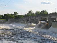 Coon Rapids Dam
While commercial traffic on the Mississippi River once passed through Coon Rapids - steamboats could reach as far as St. Cloud under certain conditions - the construction of the Coon Rapids Dam marked the city as the northern terminus of the navigable portion of the river.
U.S. Route 10 and Minnesota State Highways 47 and 610 are three of the main arterial routes in the city.
Coon Rapids Riverdale Station is served by the Northstar Commuter Rail line connecting the northwest suburbs and downtown Minneapolis; the line opened in November 2009.[5]
Notable citizens and natives
- Dan Johnson - first baseman and designated hitter in the Tampa Bay Rays organization.
- Rockie Lynne - Country singer formerly signed to Universal South Records While he was born in Statesville, North Carolina, in recent years he has called Coon Rapids home.
References
- ^ a b "2010 Census Redistricting Data (Public Law 94-171) Summary File". American FactFinder. U.S. Census Bureau, 2010 Census. http://factfinder2.census.gov/faces/tableservices/jsf/pages/productview.xhtml?pid=DEC_10_PL_GCTPL2.ST13&prodType=table. Retrieved 23 April 2011.
- ^ a b "American FactFinder". United States Census Bureau. http://factfinder.census.gov. Retrieved 2008-01-31.
- ^ "US Board on Geographic Names". United States Geological Survey. 2007-10-25. http://geonames.usgs.gov. Retrieved 2008-01-31.
- ^ Miller, Alicia (2006-02-03). "Long Live Coon Rapids". ABC Newspapers. http://abcnewspapers.com/2006/february/3letterstoeditor.html. Retrieved 2010-09-07.
- ^ Levy, Paul (2007-12-11). "Northstar set to roll, but how far?". Star Tribune. http://www.startribune.com/local/north/12389261.html. Retrieved 2010-09-07.
External links
Municipalities and communities of Anoka County, Minnesota Cities Andover | Anoka | Bethel | Blaine‡ | Centerville | Circle Pines | Columbia Heights | Columbus | Coon Rapids | East Bethel | Fridley | Ham Lake | Hilltop | Lexington | Lino Lakes | Nowthen | Oak Grove | Ramsey | St. Francis | Spring Lake Park‡

Township Unincorporated
communityLinwood
Ghost town Footnotes ‡This populated place also has portions in an adjacent county or counties
Categories:- Cities in Minnesota
- Minnesota populated places on the Mississippi River
- Populated places in Anoka County, Minnesota
- Populated places established in 1857


Wikimedia Foundation. 2010.