- O'Hare Transfer (Metra)
-
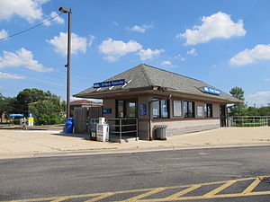
O'Hare Transfer


Station statistics Address 10300 Zemke Boulevard
Chicago, Illinois 60666Coordinates 41°59′42″N 87°52′50″W / 41.9950°N 87.8806°WCoordinates: 41°59′42″N 87°52′50″W / 41.9950°N 87.8806°W Lines Connections O'Hare International Airport Shuttle Bus Platforms 2 side platforms Tracks 2 Other information Opened 1996 Accessible 
Fare zone D Services North Central Service, Suburban Transit Access Route (future) Preceding station Metra Following station toward AntiochNorth Central Service toward Union StationO'Hare Transfer is a commuter railroad station along Metra's North Central Service that serves Chicago's O'Hare International Airport. The station is 18.6 miles (29.9 km) away from Union Station, the southern terminus of the line.[1] The station is located at the dead end of Zemke Boulevard off of Manneheim Road (US 12-45) within former Economy Parking Lot F; however, that address is not given by Metra or by the airport. No access to or from the station is available other than by O'Hare's Shuttle Bus, which takes passengers to the Airport Transit System in Parking Lot E. An effort is currently under way to extend the people mover into a parking garage designed to replace the former parking lot, thereby providing more direct access between the two systems.[2] The station is a possible terminus of Metra's planned Suburban Transit Access Route.
Owing to the limited frequency offered by the North Central Service, the station is not currently a significant means of access for travelers to O'Hare. However, a single outbound North Central Service train operates daily nonstop service from Union Station to the O'Hare transfer station with a scheduled 27-minute travel time.
References
- ^ Metra Railfan Tips - North Central Service
- ^ "Inside Chicago's plan to get you to O'Hare" (PDF). Chicago Tribune. February 19, 2007. http://www.flychicago.com/news/pdf/Tribune2-19-07.pdf.
External links
Categories:- Illinois railway station stubs
- Metra stations
- Railroad stations along former Soo Lines
- Airport railway stations in the United States
- Railway stations opened in 1996
- O'Hare International Airport

Wikimedia Foundation. 2010.