- Maria Schmolln
-
Maria Schmolln 
 Maria Schmolln
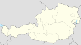
Country Austria State Upper Austria District Braunau am Inn Mayor Wilfried Gerner (ÖVP) Area 34.49 km2 (13 sq mi) Elevation 557 m (1828 ft) Population 1,374 (1 January 2011)[1] - Density 40 /km² (103 /sq mi) Time zone CET/CEST (UTC+1/+2) Licence plate BR Postal code 5241 Area code 07743 Website www.maria-schmolln.at Coordinates: 48°08′00″N 13°13′00″E / 48.1333333°N 13.2166667°E
Maria Schmolln is a municipality in the district Braunau am Inn in Upper Austria, Austria.
References
Altheim · Aspach · Auerbach · Braunau am Inn · Burgkirchen · Eggelsberg · Feldkirchen bei Mattighofen · Franking · Geretsberg · Gilgenberg am Weilhart · Haigermoos · Handenberg · Helpfau-Uttendorf · Hochburg-Ach · Höhnhart · Jeging · Kirchberg bei Mattighofen · Lengau · Lochen · Maria Schmolln · Mattighofen · Mauerkirchen · Mining · Moosbach · Moosdorf · Munderfing · Neukirchen an der Enknach · Ostermiething · Palting · Perwang am Grabensee · Pfaffstätt · Pischelsdorf am Engelbach · Polling im Innkreis · Roßbach · Sankt Georgen am Fillmannsbach · Sankt Johann am Walde · Sankt Pantaleon · Sankt Peter am Hart · Sankt Radegund · Sankt Veit im Innkreis · Schalchen · Schwand im Innkreis · Tarsdorf · Treubach · Überackern · Weng im Innkreis
Categories:- Cities and towns in Upper Austria
- Upper Austria geography stubs


Wikimedia Foundation. 2010.