- Karbi Anglong District
-
Karbi Anglong — District — District location in Assam
Country  India
IndiaState Assam Capital Diphu Area – Total 10,434 km2 (4,028.6 sq mi) Population (2011) – Total 965,280 Time zone IST (UTC+5:30) Website http://www.karbianglong.in Karbi Anglong district is the largest amongst the 27 administrative districts of Assam state in north-eastern India. The district is bounded by Golaghat district on the east, Meghalaya state and Marigaon district on the west, Nagaon and Golaghat districts on the north and Dima Hasao district and Nagaland state on the south. The district is located between 25º33' - 26º35' North Latitudes and 92º10' - 93º50' East Longitudes. Diphu town is the administrative headquarters of the district. Karbi Anglong District occupies an area of 10,434 square kilometres (4,029 sq mi),[1] comparatively equivalent to the island of Hawaii.[2]
Contents
History
During the British rule, the territory of the present district was part of the ‘Scheduled District’ constituted in 1874. Later, Mikir Hills tract was constituted as “Partially Excluded areas” under the Govt. of India Act, 1935. On November 17, 1951 a new district, the United Mikir Hills and North Cachar Hills district was created by combining some parts of the districts of Sibsagar (now Golaghat), Nagaon, Cachar and United Khasi and Jayantia Hills district of present day Meghalaya state. This was followed by bifurcation of the erstwhile district of United Mikir and North Cachar Hills district into two separate districts — Mikir Hills district and North Cachar Hills district — on 2 February 1970.[3] Mikir Hills district was renamed as Karbi Anglong district on 14 October 1976.[3]
Economy
In 2006 the Indian government named Karbi Anglong one of the country's 250 most backward districts (out of a total of 640).[4] It is one of the eleven districts in Assam currently receiving funds from the Backward Regions Grant Fund Programme (BRGF).[4]
Divisions
The district has three sub-divisions: Diphu, Hamren and Bokajan. Diphu sub-division is further divided into two revenue circles: Diphu and Phuloni. Hamren sub-division consists of one revenue circle :Dankamukam Revenue circle ; and Bokajan sub-division consists of one revenue circle:Silonijan.
- Diphu Sub-Division:
- Diphu Revenue Circle
- Phuloni Revenue Circle
- Bokajan Sub-Division:
- Silonijan Revenue Circle
- Hamren Sub-Division:
- Dongkamukam Revenue circle
The four Vidhan Sabha constituencies of the district are Bokajan, Howraghat, Diphu and Vothatlangso. All are part of the 3 S.T. Autonomous District. Lok Sabha constituency. Diphu town is the district headquarters. Other towns of this district are Bokajan, Donkamokam, Dokmoka, Hamren and Howraghat. Total number of villages in this district is 2633.
There are four Assam Legislative Assembly constituencies in this district: Bokajan, Howraghat, Diphu, and Baithalangso.[5] All four are designated for scheduled tribes.[5] They are all in the Autonomous District Lok Sabha constituency.[6]
Demographics
According to the 2011 census Karbi Anglong District has a population of 965,280,[7] roughly equal to the nation of Fiji[8] or the US state of Montana.[9] This gives it a ranking of 451st in India (out of a total of 640).[7] The district has a population density of 93 inhabitants per square kilometre (240 /sq mi) .[7] Its population growth rate over the decade 2001-2011 was 18.69 %.[7] Karbi Anglong has a sex ratio of 956 females for every 1000 males,[7] and a literacy rate of 73.52 %.[7]
Population of this district is: Hindus 670,139, Christians 117,738, Muslims 18,091 (2.22%).
A number of indigenous peoples reside in this district. The Karbis are the most prominent amongst them. Other indigenous peoples residing in this district include the Rengma Nagas, the Dimasas, the Bodos, the Kukis, the Garos, the Tiwas, the Khasis, the Thadous, the Hmars, the Mizos and the Chakmas.
Languages
Languages spoken include Aiton, which with approximately 1500 speakers is closely related to Shan and written in the Burmese script.[10]
Culture
Places of interest
A hilly district of Assam Karbi Anglong is a very beautiful place in the lap of nature. It is still somewhat unknown to the tourist in spite of its enchanting natural green forests and picturesque hills. In addition to this there are the multi-coloured cultures and traditions.
- Diphu: It is a small but very charming busy town. The town is locate on a hill.
- Silbheta: It is a favourite picnic spot located at adistance of 37 km from Diphu. The place surrounded by rain forests.
- Akashiganga: 65 km away from Diphu, here a divine stream of water flows down from the high hill.
- Amreng: Amreng is a very attractive place in Hamren. Here a blue water stream falls down from a huge rock.
- Garampani: Garampani is a sanctuary of Nambor Reserve Forest. There is hot water spring in here near the national highway.
Flora and fauna
In 1952 Karbi Anglong district became home to the Garampani Wildlife Sanctuary, which has an area of 6 km2 (2.3 sq mi).[11]
For any visitor to Karbi Anglong, a must read book is A Naturalist in Karbi Anglong by Assam's well known naturalist Dr Anwaruddin Choudhury. He narrated his travels and wildlife observations in different parts of Karbi Anglong during his tenure in the district as a civil servant. The book is profusely illustrated with drawings and photos.[12][13]
Media
Karbi Anglong is popular for its fast growth in media. The Arleng Daily, a Karbi daily is the first daily newspaper in Karbi Anglong. since, then seven dailies in Karbi, Assamese and English language in the district. Thekar, a Karbi daily is the highest circulated daily from the district brought out by Thekar Group. A local cable "KAT Channel" from Thekar Group is also very popular for its news coverage and local traditional entertainment programmes.
References
- ^ Srivastava, Dayawanti et al. (ed.) (2010). "States and Union Territories: Assam: Government". India 2010: A Reference Annual (54th ed.). New Delhi, India: Additional Director General, Publications Division, Ministry of Information and Broadcasting (India), Government of India. pp. 1116. ISBN 978-81-230-1617-7.
- ^ "Island Directory Tables: Islands by Land Area". United Nations Environment Program. 1998-02-18. http://islands.unep.ch/Tiarea.htm. Retrieved 2011-10-11. "Hawai'i (Big Island) 10,434km2"
- ^ a b Law, Gwillim (2011-09-25). "Districts of India". Statoids. http://www.statoids.com/yin.html. Retrieved 2011-10-11.
- ^ a b Ministry of Panchayati Raj (September 8, 2009). "A Note on the Backward Regions Grant Fund Programme". National Institute of Rural Development. http://www.nird.org.in/brgf/doc/brgf_BackgroundNote.pdf. Retrieved September 27, 2011.
- ^ a b "List of Assembly Constituencies showing their Revenue & Election District wise break - up". Chief Electoral Officer, Assam website. http://ceoassam.nic.in/Gen_Informations/2.1%20-%20DEOs%20wise%20ACs%20breakup.pdf. Retrieved 26 September 2011.
- ^ "List of Assembly Constituencies showing their Parliamentary Constituencies wise break - up". Chief Electoral Officer, Assam website. http://ceoassam.nic.in/Gen_Informations/2.2%20-%20PC-wise%20LAC%20breakup.pdf. Retrieved 26 September 2011.
- ^ a b c d e f "District Census 2011". Census2011.co.in. 2011. http://www.census2011.co.in/district.php. Retrieved 2011-09-30.
- ^ US Directorate of Intelligence. "Country Comparison:Population". https://www.cia.gov/library/publications/the-world-factbook/rankorder/2119rank.html. Retrieved 2011-10-01. "Fiji 883,125 July 2011 est."
- ^ "2010 Resident Population Data". U. S. Census Bureau. http://2010.census.gov/2010census/data/apportionment-pop-text.php. Retrieved 2011-09-30. "Montana 989,415"
- ^ M. Paul Lewis, ed (2009). "Aiton: A language of India". Ethnologue: Languages of the World (16th edition ed.). Dallas, Texas: SIL International. http://www.ethnologue.com/show_language.asp?code=aio. Retrieved 2011-09-28.
- ^ Indian Ministry of Forests and Environment. "Protected areas: Assam". http://oldwww.wii.gov.in/envis/envis_pa_network/index.htm. Retrieved September 25, 2011.
- ^ Choudhury, A.U. (1993). A Naturalist in Karbi Anglong. Gibbon Books, Guwahati, India.88pp+maps.
- ^ Choudhury, A.U. (2009). A Naturalist in Karbi Anglong. Revised 2nd edn. Gibbon Books, Guwahati, India.152pp.
Karbi Anglong is popular for its fast growth in media. The Arleng Daily, a Karbi daily is the first daily newspaper in the district was brought out in the year 2004. Since then, many local daily has came up in the district. Its has seven dailies in Karbi, Assamese and English language. Thekar, a Karbi daily is the highest circulated daily from the district brought out by Thekar Group. A local cable "KAT Channel" from Thekar Group is also very popular for its news coverage and local traditional entertainment programmes.working in good condition.
External links

Nagaon district Ri-Bhoi district, Meghalaya 
Dima Hasao district  Karbi Anglong District (West)

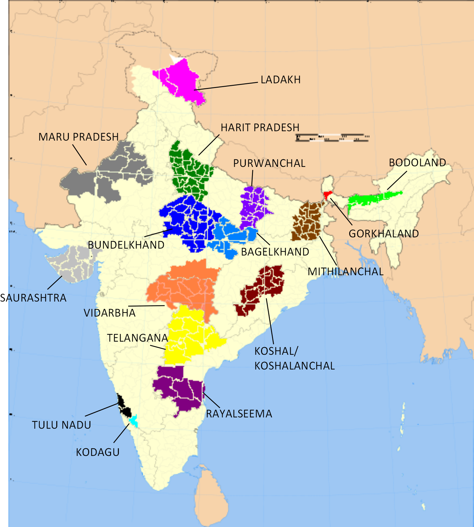
Jaintia Hills district, Meghalaya Golaghat district Nagaon district Dimapur district, Nagaland Karbi Anglong District (East) Dima Hasao district Peren district, Nagaland Aspirant states of India Bodoland (Assam) · Bundelkhand (Uttar Pradesh and Madhya Pradesh) · Delhi · Gondwana (northern Deccan Plateau) · Gorkhaland (West Bengal) · Harit Pradesh (Uttar Pradesh) · Kamtapur / Greater Cooch Behar (West Bengal) · Karbi Anglong (Assam) · Kodagu (Karnataka) · Kongu Nadu (Tamil Nadu) · Kosal/Koshal (Orissa) · Ladakh (Jammu and Kashmir) · Mahakoshal (Madhya Pradesh) · Mithila (Bihar) · Panun Kashmir (Jammu and Kashmir) · Purvanchal (Uttar Pradesh) · Rayalaseema (Andhra Pradesh) · Telangana (Andhra Pradesh) · Tulu Nadu (Karnataka and Kerala) · Vidarbha (Maharashtra) · Maru Pradesh (Rajasthan) · Vindhya Pradesh (Madhya Pradesh) Categories:
- Districts of Assam
- Proposed states and union territories in India
- Autonomous regions of India
- States and territories established in 1970
- Karbi Anglong district
- Diphu Sub-Division:

Wikimedia Foundation. 2010.