- Commana
-
Commana
Kommanna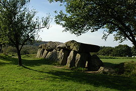
Mougau Gallery grave 
 CommanaLocation within Brittany region
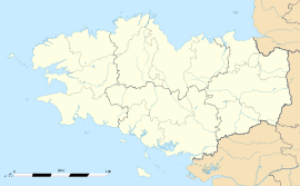 Commana
Administration Country France Region Brittany Department Finistère Arrondissement Morlaix Canton Sizun Intercommunality Pays de Landivisiau Mayor Marie-Thérèse Lancien
(2008–2014)Statistics Elevation 104–372 m (341–1,220 ft) Land area1 39.90 km2 (15.41 sq mi) Population2 1,064 (2008) - Density 27 /km2 (70 /sq mi) INSEE/Postal code 29038/ 29450 1 French Land Register data, which excludes lakes, ponds, glaciers > 1 km² (0.386 sq mi or 247 acres) and river estuaries. 2 Population without double counting: residents of multiple communes (e.g., students and military personnel) only counted once. Coordinates: 48°24′51″N 3°57′10″W / 48.4142°N 3.9528°W
Commana (Breton: Kommanna) is a commune in the Finistère department of Brittany in northwestern France.
Contents
Population
Inhabitants of Commana are called in French Commanéens.
Historical populations Year Pop. ±% 1793 2,664 — 1800 2,045 −23.2% 1806 2,332 +14.0% 1821 2,457 +5.4% 1831 2,670 +8.7% 1836 2,691 +0.8% 1841 2,881 +7.1% 1846 2,976 +3.3% 1851 2,781 −6.6% 1856 2,712 −2.5% 1861 2,763 +1.9% 1866 2,660 −3.7% 1872 2,645 −0.6% 1876 2,634 −0.4% 1881 2,546 −3.3% 1886 2,622 +3.0% 1891 2,625 +0.1% 1896 2,593 −1.2% 1901 2,608 +0.6% 1906 2,557 −2.0% 1911 2,414 −5.6% 1921 2,064 −14.5% 1926 2,035 −1.4% 1931 1,933 −5.0% 1936 1,849 −4.3% 1946 1,655 −10.5% 1954 1,480 −10.6% 1962 1,462 −1.2% 1968 1,370 −6.3% 1975 1,263 −7.8% 1982 1,153 −8.7% 1990 1,061 −8.0% 1999 988 −6.9% 2008 1,064 +7.7% Breton language
In 2009, 45.1% of primary-school children attended bilingual schools.[1]
See also
- Communes of the Finistère department
- Parc naturel régional d'Armorique
References
- ^ (French) Ofis ar Brezhoneg: Enseignement bilingue
- Mayors of Finistère Association (French);
External links
- Official website (French)
- French Ministry of Culture list for Commana (French)
Categories:- Communes of Finistère
- Finistère geography stubs


Wikimedia Foundation. 2010.