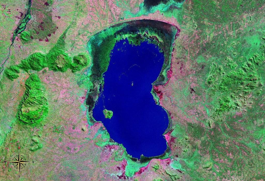
Lake Chilwa

Lake Chilwa
Lake Chilwa
seen from space (false color)
Location Zomba District
Coordinates 15°18′S 35°42′E / 15.3°S 35.7°E / -15.3; 35.7Coordinates: 15°18′S 35°42′E / 15.3°S 35.7°E / -15.3; 35.7
Basin countries Malawi
Max. length 60 km
Max. width 40 km

Lake Chilwa is the second-largest lake in Malawi after Lake Malawi. It is in eastern Zomba District, near the border with Mozambique. Approximately 60 km long and 40 km wide, the lake is surrounded by extensive wetlands.

335 villages with over 60,000 inhabitants engage in fishing the lake, and pull in over 17,000 metric tons each year, 20% of all the fish caught in Malawi.

The lake has no outlet, and is at risk for drying up if the water in its catchment is diverted for human use. The Danish International Development Agency has been working to ensure preservation of the lake and its wetlands.

There is a large island in the middle of the lake called Chisi Island.


Wikimedia Foundation. 2010.

Игры ⚽ Нужна курсовая?

Look at other dictionaries:

  • Chilwa — See Geographische Lage: Südost Malawi Zuflüsse: Sambani, Phalombe Abflüsse: keine Städte am Ufer: keine Daten …   Deutsch Wikipedia

  • Chilwa-See — Bild gesucht  BW Geographische Lage Südost Malawi Zuflüsse …   Deutsch Wikipedia

  • Lake Chiuta — is a shallow lake on the border between Malawi and Mozambique. It lies to the north of Lake Chilwa, which has no outlet, and the lakes are separated by a sandy ridge. Both lakes lie in a graben which runs northeast southwest, east of the main… …   Wikipedia

  • lake — lake1 /layk/, n. 1. a body of fresh or salt water of considerable size, surrounded by land. 2. any similar body or pool of other liquid, as oil. 3. (go) jump in the lake, (used as an exclamation of dismissal or impatience.) [bef. 1000; ME lak(e) …   Universalium

  • Lake — /layk/, n. Simon, 1866 1945, U.S. engineer and naval architect. * * * I Relatively large body of slow moving or standing water that occupies an inland basin. Lakes are most abundant in high northern latitudes and in mountain regions, particularly …   Universalium

  • Chilwa, Lake — Lake, southeastern Malawi. It lies in a depression southeast of Lake Malawi between the Shire Highlands and the Mozambique border. Today it covers about 1,000 sq mi (2,600 sq km); it was much larger when David Livingstone arrived there in 1859,… …   Universalium

  • Malombe, Lake — ▪ lake, Malaŵi       lake fed and drained by the Shire River in southern Malaŵi. It lies in a broken depression running northwest from Lake Chilwa to Lake Nyasa (Nyasa, Lake), parallel to the Shire Rift Valley. The lake is fed by the Shire River… …   Universalium

  • Schilwa — Chilwa See Geographische Lage: Südost Malawi Zuflüsse: Sambani, Phalombe Abflüsse: keine Städte am Ufer: keine Daten …   Deutsch Wikipedia

  • Schirwa — Chilwa See Geographische Lage: Südost Malawi Zuflüsse: Sambani, Phalombe Abflüsse: keine Städte am Ufer: keine Daten …   Deutsch Wikipedia

  • East African lakes — ▪ lake system, East Africa Introduction  group of lakes in East Africa (eastern Africa). The majority of the East African lakes lie within the East African Rift System, which forms a part of a series of gigantic fissures in the Earth s crust… …   Universalium

Share the article and excerpts

Direct link
Do a right-click on the link above
and select “Copy Link”