- Maywood, New Jersey
-
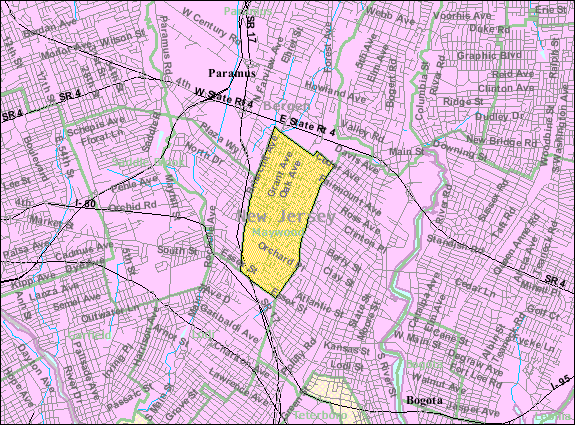
Maywood, New Jersey — Borough — Map highlighting Maywood's location within Bergen County. Inset: Bergen County's location within New Jersey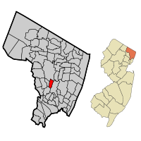 Census Bureau map of Maywood, New Jersey
Coordinates: 40°54′18″N 74°3′46″W / 40.905°N 74.06278°WCoordinates: 40°54′18″N 74°3′46″W / 40.905°N 74.06278°W Country United States State New Jersey County Bergen Incorporated June 29, 1894 Government – Type Borough – Mayor Dr. Timothy J. Eustace – Administrator Thomas H. Richards[1] Area – Total 1.3 sq mi (3.4 km2) – Land 1.3 sq mi (3.4 km2) – Water 0.0 sq mi (0.0 km2) Elevation[2] 85 ft (26 m) Population (2010)[3] – Total 9,555 – Density 7,278.6/sq mi (2,810.3/km2) Time zone Eastern (EST) (UTC-5) – Summer (DST) EDT (UTC-4) ZIP code 07607 Area code(s) 201 FIPS code 34-44880[4][5] GNIS feature ID 0878208[6] Website http://www.maywoodboro.org Maywood is a borough in Bergen County, New Jersey, United States. As of the 2010 United States Census, the borough population was 9,555.[3]
Maywood was incorporated as a borough on June 29, 1894, from portions of Midland Township, based on the results of a referendum held that day, at the height of the "Boroughitis" phenomenon then sweeping through Bergen County.[7]
Contents
Geography
Maywood is located at 40°54′18″N 74°03′46″W / 40.905030°N 74.062795°W (40.905030, -74.062795).[8]
According to the United States Census Bureau, the borough has a total area of 1.3 square miles (3.4 km2), all of it land.
Demographics
Historical populations Census Pop. %± 1900 536 — 1910 889 65.9% 1920 1,618 82.0% 1930 3,398 110.0% 1940 4,052 19.2% 1950 8,667 113.9% 1960 11,460 32.2% 1970 11,087 −3.3% 1980 9,895 −10.8% 1990 9,473 −4.3% 2000 9,523 0.5% 2010 9,555 0.3% Population 1930 - 1990.[9][10] As of the census[4] of 2000, there were 9,523 people, 3,710 households, and 2,626 families residing in the borough. The population density was 7,326.2 people per square mile (2,828.3/km2). There were 3,777 housing units at an average density of 2,905.7 per square mile (1,121.8/km2). The racial makeup of the borough was 84.57% White, 2.79% African American, 0.07% Native American, 7.16% Asian, 0.01% Pacific Islander, 3.31% from other races, and 2.08% from two or more races. Hispanic or Latino of any race were 11.71% of the population.
There were 3,710 households out of which 29.1% had children under the age of 18 living with them, 56.3% were married couples living together, 11.0% had a female householder with no husband present, and 29.2% were non-families. 24.9% of all households were made up of individuals and 13.3% had someone living alone who was 65 years of age or older. The average household size was 2.56 and the average family size was 3.09.
In the borough the population was spread out with 21.1% under the age of 18, 6.2% from 18 to 24, 30.8% from 25 to 44, 24.4% from 45 to 64, and 17.5% who were 65 years of age or older. The median age was 40 years. For every 100 females there were 86.9 males. For every 100 females age 18 and over, there were 83.5 males.
The median income for a household in the borough was $62,113, and the median income for a family was $73,419. Males had a median income of $49,566 versus $38,193 for females. The per capita income for the borough was $28,117. About 2.5% of families and 3.3% of the population were below the poverty line, including 4.6% of those under age 18 and 3.3% of those age 65 or over.
Government
Local government
Maywood is governed under the Borough form of New Jersey municipal government. The government consists of a Mayor and a Borough Council comprising six council members, with all positions elected at large. A Mayor is elected directly by the voters to a four-year term of office and only votes to break a tie. The Borough Council consists of six members elected to serve three-year terms on a staggered basis, with two seats coming up for election each year.[11]
As of 2011[update], the Mayor of Maywood is Timothy J. Eustace, (Democratic Party, term ends December 31, 2011). Members of the Borough Council are Council President John E. Savage (D, 2012), Marianne F. Auriemma (D, 2012), Paul S. Bresko (D, 2011), Adrian Febre (R, 2013), Erich Fleischmann (D, 2013) and Nancy M. Jengo (D, 2011).[12]
In elections held on November 2, 2010, ~49% of the registered voters turned out to fill two seats on the Borough Council. Democratic incumbent Erich Fleischmann (for his third term) and Republican newcomer Adrian Febre won, with Febre's win giving the Republicans their first seat on the Maywood Council since 2005. Losing were newcomers Democrat Rich Bolan and Independent Rick DeHere. Incumbent Lorraine Lapin did not run to retain her seat.[13]
In elections held on November 3, 2009, ~47% of the registered voters turned out to fill two seats on the Borough Council. Incumbents Jack Savage (for his third term) and Marianne Auriemma (for her first full term after serving a year on an unexpired seat) retained their seats in an uncontested election.[14]
In elections held on November 4, 2008, ~80% of the registered voters turned out to fill three seats on the Borough Council. Two were for three-year terms and one was for the last year of an unexpired term. Incumbent Nancy Jengo (2,512 votes) and newcomer Paul Bresko (2,347) won the two three-year seats over Anthony Klymenko (1,815). Newcomer Marianne Auriemma (2,478) won the one-year unexpired term unopposed.
In elections held on November 6, 2007, 39% of registered voters turned out to fill a four-year term for mayor and two three-year seats on the Borough Council. Democratic councilman Timothy J. Eustace (1,179 votes) won the mayoral race, defeating Republican challenger Alfred M. Ballerini (832) to become mayor. Democratic incumbents Lorraine LaPietra (1,124) and Erich Fleischman (1,111) won re-election to the council, with Republicans Antoinette Schmidt (853) and Susan D. Preziosi (851) trailing.[15][16][17]
On Election Day, November 7, 2006, voters filled two seats on the Borough Council. As of Election Day, the council was composed entirely of Democrats, in a community in which registered Democrats outnumber Republicans by a small margin. The two Democratic incumbents, Timothy J. Eustace (1,822 votes) and Jack Savage (1,734) won re-election, defeating Republican Anthony P. Klymenko (1,040). The Democratic sweep gave Eustace his fourth term in office and Savage his second, and continued full Democratic control of the Council for 2007.[18][19][20]
Due to the small population of Maywood, it is able to combine its Planning and Zoning Board into one entity.
Federal, state and county representation
Maywood is in the 9th Congressional district and is part of New Jersey's 38th state legislative district.[21]
New Jersey's Ninth Congressional District is represented by Steve Rothman (D, Fair Lawn). New Jersey is represented in the United States Senate by Frank Lautenberg (D, Cliffside Park) and Bob Menendez (D, Hoboken).
38th District of the New Jersey Legislature, which is represented in the New Jersey Senate by Robert M. Gordon (D, Fair Lawn) and in the New Jersey General Assembly by Joan Voss (D, Fort Lee) and Connie Wagner (D, Paramus).[22] The Governor of New Jersey is Chris Christie (R, Mendham).[23] The Lieutenant Governor of New Jersey is Kim Guadagno (R, Monmouth Beach).[24]
Bergen County's County Executive is Kathleen Donovan (R, Rutherford; term ends December 31, 2014).[25] The Board of Chosen Freeholders is the county's legislative body and its seven members are elected at-large on a staggered basis, with two or three seats coming up for election each year.[26] As of 2011, Bergen County's Freeholders are Chairman John Driscoll, Jr. (R, 2012; Paramus),[27] Vice-Chairwoman Maura DeNicola (R, 2013; Franklin Lakes),[28] Chair Pro Tempore John D. Mitchell (R, 2013; Cliffside Park)[29] John A. Felice (R, 2013; River Edge),[30] David L. Ganz (D, 2011; Fair Lawn),[31] Robert G. Hermansen (R, 2012; Mahwah)[32] and Bernadette P. McPherson (D, 2011; Rutherford).[33][34] Other countywide constitutional officials are Sheriff Michael Saudino (R), Surrogate Michael R. Dressler (D, Cresskill) and County Clerk Elizabeth Randall (R, Westwood).[35]
Politics
As of April 1, 2006, out of a 2004 Census estimated population of 9,505 in Maywood, there were 5,474 registered voters (57.6% of the population, vs. 55.4% in all of Bergen County). Of registered voters, 1,085 (19.8% vs. 20.7% countywide) were registered as Democrats, 899 (16.4% vs. 19.2% countywide) were registered as Republicans and 3,487 (63.7% vs. 60.1% countywide) were registered as Undeclared. There were three voters registered to other parties.[36]
On the national level, Maywood leans slightly toward the Democratic Party. In the 2004 presidential election, Democrat John Kerry received 51% of the vote here, defeating Republican George W. Bush, who received around 48%.[37]
Education
The Maywood Public Schools serve students in kindergarten through eighth grade.
Memorial School serves kindergarten to third grade (354 students as of 2005-06[38]). For the 1996-97 school year, Memorial School was formally designated as a National Blue Ribbon School, the highest honor that an American school can achieve.[39]
Maywood Avenue School serves fourth through eighth grade (459 students[38]). The school offers a wide variety of after school activities ranging from cheerleading to chess club. All students have the opportunity to contribute to their school newspaper, The Hawk, and eighth graders may assist with their yearbook.
After graduating from Maywood Avenue School, students in public school for grades 9 - 12 attend Hackensack High School in Hackensack, as part of a sending/receiving relationship with the Hackensack Public Schools, together with students from Rochelle Park and South Hackensack.[40]
Students also attend the Bergen County Academies, Bergen County Technical High School or other schools including St. Peter's Preparatory School, Bergen Catholic High School, Don Bosco Preparatory High School, Saint Joseph Regional High School, Paramus Catholic High School, Academy of the Holy Angels, and Immaculate Heart Academy
Religion
Maywood is home to Our Lady Queen of Peace Roman Catholic Church, First Presbyterian Church, Lutheran Church of the Redeemer, Zion Lutheran Church, St. Martin's Episcopal Church, and Temple Beth Israel, a Reconstructionist synagogue established in 1928, which moved to its current location in 1931.[41]
Transportation
New Jersey Transit bus routes 144, 145, 148, 162, 163 and 164 serve the Port Authority Bus Terminal in Midtown Manhattan; The 175 route serves the George Washington Bridge Bus Terminal; and the 712, 751, 752, 753, 755, 758 and 770 provide local service in New Jersey.[42]
Route 17 passes through Maywood. Main roads in Maywood include Maywood Avenue, Central Avenue, Passaic Street, and Spring Valley Road.
Entertainment and eateries
Maywood has a variety of entertainment features that, for the most part, citizens have access to on a daily basis. The "center" of the town is located on West Pleasant Ave. from the intersection of Maywood Ave. to Lincoln Ave. This section of Maywood is essentially a business district where most of the local restaurants and shops reside. Eateries uptown include three pizza places (one being a hybrid with a luncheonette), two Chinese take-out restaurants (one being a Chinese-Mexican hybrid), a cafe, a formal restaurant, a bakery, a pub, and a bagel place. Two convenience stores also reside uptown, as does a Hallmark and a fitness center. In April 2009, a Subway was opened uptown, making this restaurant the first fast food restaurant franchise to open in Maywood.
This "business district" of Maywood was recently renovated through a "Street Scapes" grant. It was used to fix up the sidewalks, streets, lighting, etc.
Maywood's Memorial Park is across the street from Memorial School on Grant Ave. and is open to anyone. The park includes multiple baseball fields and a vast open field for soccer, football, running, etc. Further back is a multi-hoop concrete basketball court and two jungle gyms with swings. Around the circumference of the park is a 1/2 mile long bike path.
Corporate residents
To this day, Coca-Cola uses as an ingredient a coca leaf extract prepared by a Stepan Company plant in Maywood.[43] The facility, which had been known as the Maywood Chemical Works (and is also a known Superfund site[44]), was purchased by Stepan in 1959.[45] The plant is the only commercial entity in the country authorized by the Drug Enforcement Agency to import coca leaves, which come primarily from Peru. The non-narcotic extract is sold to Coke, while the active ingredient is sold to a pharmaceutical firm for medicinal purposes.[46]
Also located in Maywood are a Sears distribution center and a Duane Reade.
Historic sites
The Maywood Train Station has been restored after the question came up about possibly destroying the famous landmark. It has been listed on the National Register of Historic Places since 2003 as Building #03000487.[47] The station was restored by the all volunteer, non-profit Maywood Station Historical Committee who now operate the historic site as the Maywood Station Museum.[48]
Notable residents
Notable current and former residents of Maywood include:
- Beverly Armstrong (born 1934), pitcher for Rockford Peaches.[49]
- Alex Vincent (born 1981), known for his roles as a child actor in the Child's Play movies.[50]
References
- ^ Borough Administrator, Borough of Maywood. Accessed February 10, 2011.
- ^ U.S. Geological Survey Geographic Names Information System: Borough of Maywood, Geographic Names Information System, accessed October 1, 2007.
- ^ a b "Race, Hispanic or Latino, Age, and Housing Occupancy: 2010 Census Redistricting Data (Public Law 94-171) Summary File (QT-PL), Maywood borough, New Jersey". U.S. Census Bureau, American FactFinder 2. http://factfinder2.census.gov. Retrieved August 3, 2011.
- ^ a b "American FactFinder". United States Census Bureau. http://factfinder.census.gov. Retrieved 2008-01-31.
- ^ A Cure for the Common Codes: New Jersey, Missouri Census Data Center. Accessed July 14, 2008.
- ^ "US Board on Geographic Names". United States Geological Survey. 2007-10-25. http://geonames.usgs.gov. Retrieved 2008-01-31.
- ^ "The Story of New Jersey's Civil Boundaries: 1606-1968", John P. Snyder, Bureau of Geology and Topography; Trenton, New Jersey; 1969. p. 81.
- ^ "US Gazetteer files: 2010, 2000, and 1990". United States Census Bureau. 2011-02-12. http://www.census.gov/geo/www/gazetteer/gazette.html. Retrieved 2011-04-23.
- ^ New Jersey Resident Population by Municipality: 1930 - 1990, Workforce New Jersey Public Information Network. Accessed March 1, 2007.
- ^ Historical Population Trends in Bergen County (1900 - 2000), Bergen County, New Jersey. Accessed December 23, 2007.
- ^ 2005 New Jersey Legislative District Data Book, Rutgers University Edward J. Bloustein School of Planning and Public Policy, April 2005, p. 157.
- ^ Mayor and Council, Borough of Maywood. Accessed February 10, 2011.
- ^ Alvarado, Monsy. "Dems lose control of Maywood Borough Council", The Record (Bergen County), November 2, 2010. Accessed May 24, 2011.
- ^ Clark, Susan Joy. "Democrats gain two seats in uncontested election", Community News, November 12, 2009. Accessed May 24, 2011.
- ^ "Maywood municipal elections", The Record (Bergen County), October 29, 2007. Accessed November 28, 2007.
- ^ "Maywood election results", The Record (Bergen County), November 6, 2007. Accessed November 28, 2007.
- ^ Bergen County election results, The Record (Bergen County), November 7, 2007. Accessed November 10, 2007.
- ^ Maywood Election Guide, The Record (Bergen County), November 1, 2006.
- ^ Maywood election results, The Record (Bergen County), November 8, 2006.
- ^ Bergen County 2006 General Election Results, Bergen County, New Jersey. Accessed February 1, 2007.
- ^ 2008 New Jersey Citizen's Guide to Government, New Jersey League of Women Voters, p. 60. Accessed September 30, 2009.
- ^ "Legislative Roster: 2010-2011 Session". New Jersey Legislature. http://www.njleg.state.nj.us/members/roster.asp. Retrieved 2010-02-08.
- ^ "About the Governor". New Jersey. http://www.nj.gov/governor/about/. Retrieved 2010-01-21.
- ^ "About the Lieutenant Governor". New Jersey. http://www.nj.gov/governor/lt/. Retrieved 2010-01-21.
- ^ Bergen County Executive, Bergen County, New Jersey. Accessed January 3, 2011.
- ^ What Is a Freeholder?, Bergen County, New Jersey. Accessed January 6, 2011.
- ^ Freeholder John Driscoll, Jr., Bergen County, New Jersey. Accessed January 11, 2011.
- ^ Maura R. DeNicola, Bergen County, New Jersey. Accessed January 11, 2011.
- ^ John D. Mitchell, Bergen County, New Jersey. Accessed January 11, 2011.
- ^ John A. Felice, Bergen County, New Jersey. Accessed January 11, 2011.
- ^ Freeholder David L. Ganz, Bergen County, New Jersey. Accessed January 11, 2011.
- ^ Freeholder Robert G. Hermansen, Bergen County, New Jersey. Accessed January 11, 2011.
- ^ Freeholder Bernadette P. McPherson, Bergen County, New Jersey. Accessed January 11, 2011.
- ^ Freeholder Home Page, Bergen County, New Jersey. Accessed January 3, 2011.
- ^ Constitutional Officers, Bergen County, New Jersey. Accessed January 3, 2011.
- ^ "County of Bergen: Voter Statistics by Municipality, Ward & District," Bergen County, New Jersey, dated April 1, 2006.
- ^ 2004 Presidential Election results: Bergen County, New Jersey Department of Law and Public Safety: Division of Elections, dated December 13, 2004.
- ^ a b Data for Maywood Public Schools, National Center for Education Statistics. Accessed May 27, 2008.
- ^ Blue Ribbon Schools Program: Schools Recognized 1982-1983 through 1999-2002 (PDF), United States Department of Education. Accessed May 11, 2006.
- ^ Hackensack High School 2006 Report Card Narrative, New Jersey Department of Education. Accessed February 12, 2008. "Hackensack High School serves the communities of Hackensack, South Hackensack, Maywood and Rochelle Park."
- ^ Who are we?, Synagogue website. Accessed February 23, 2009.
- ^ Routes by County: Bergen County, New Jersey Transit. Accessed October 22, 2008.
- ^ Benson, Drew. "Coca kick in drinks spurs export fears", The Washington Times, April 20, 2004. Accessed June 14, 2007. "Coke dropped cocaine from its recipe around 1900, but the secret formula still calls for a cocaine-free coca extract produced at a Stepan Co. factory in Maywood, N.J. Stepan buys about 100 metric tons of dried Peruvian coca leaves each year, said Marco Castillo, spokesman for Peru's state-owned National Coca Co."
- ^ FUSRAP Maywood Superfund Site, Accessed November 12th, 2009.
- ^ History, Stepan Company. Accessed June 14, 2007.
- ^ May, Clifford D. "How Coca-Cola Obtains Its Coca", The New York Times, July 1, 1988. Accessed April 11, 2008. "A Stepan laboratory in Maywood, N.J., is the nation's only legal commercial importer of coca leaves, which it obtains mainly from Peru and, to a lesser extent, Bolivia. Besides producing the coca flavoring agent for Coca-Cola, Stepan extracts cocaine from the coca leaves, which it sells to Mallinckrodt Inc., a St. Louis pharmaceutical manufacturer that is the only company in the United States licensed to purify the product for medicinal use."
- ^ NEW JERSEY - Bergen County, National Register of Historic Places. Accessed November 11, 2007.
- ^ About Us, Maywood Station Museum. Accessed March 11, 2008.
- ^ Heaphy, Leslie A.; and May, Mel Anthony. Encyclopedia of women and baseball, p. 276. McFarland & Company, 2006. ISBN 0786421002. Accessed February 10, 2011.
- ^ So instead of pursuing an acting career after starring in Child's Play 2 in 1990, Vincent left L.A. and returned to his Maywood, N.J., home with his family. "I just wanted to be a normal kid," he says. "I wanted to play baseball, hang out with my friends and not have my life disrupted by auditions."
Related reading
- Kaminski, Edward S. (2010). Maywood - The Borough, The Railroad, and The Station. Arcadia Publishing, ISBN 978-0-7385-7234-5.
External links
- Maywood official website
- Maywood Public Schools
- Maywood Public Schools's 2009–10 School Report Card from the New Jersey Department of Education
- Data for Maywood Public Schools, National Center for Education Statistics
- Hackensack High School
- Statistical data on Maywood
- FUSRAP Maywood Superfund Site
- Maywood First Aid Squad at the World Trade Center 9/11/2001 - 9/12/2001
- Maywood Station Museum
- Maywood Station Historical Committee
Municipalities and communities of Bergen County, New Jersey Cities 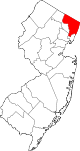
Boroughs Allendale | Alpine | Bergenfield | Bogota | Carlstadt | Cliffside Park | Closter | Cresskill | Demarest | Dumont | East Rutherford | Edgewater | Elmwood Park | Emerson | Englewood Cliffs | Fair Lawn | Fairview | Fort Lee | Franklin Lakes | Glen Rock | Harrington Park | Hasbrouck Heights | Haworth | Hillsdale | Ho-Ho-Kus | Leonia | Little Ferry | Lodi | Maywood | Midland Park | Montvale | Moonachie | New Milford | North Arlington | Northvale | Norwood | Oakland | Old Tappan | Oradell | Palisades Park | Paramus | Park Ridge | Ramsey | Ridgefield | River Edge | Rockleigh | Rutherford | Saddle River | Tenafly | Teterboro | Upper Saddle River | Waldwick | Wallington | Westwood | Wood-Ridge | Woodcliff Lake
Townships Villages Unincorporated
communitiesCategories:- Boroughs in Bergen County, New Jersey


Wikimedia Foundation. 2010.