- Erma, New Jersey
Infobox Settlement
official_name = Erma, New Jersey
settlement_type = CDP
nickname =
motto =
imagesize =
image_caption =
image_
imagesize =
image_caption =
image_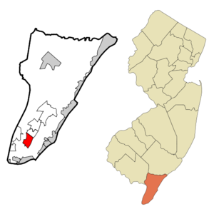
mapsize = 250x200px
map_caption = Map of Erma CDP in Cape May County
mapsize1 =
map_caption1 =subdivision_type = Country
subdivision_name =United States
subdivision_type1 = State
subdivision_name1 =New Jersey
subdivision_type2 = County
subdivision_name2 = Cape May
government_footnotes =
government_type =
leader_title =
leader_name =
leader_title1 =
leader_name1 =
established_title =
established_date =area_footnotes =
area_magnitude =
area_total_km2 = 8.7
area_land_km2 = 8.7
area_water_km2 = 0.0
area_total_sq_mi = 3.4
area_land_sq_mi = 3.3
area_water_sq_mi = 0.0population_as_of = 2000
population_footnotes =
population_total = 2088
population_density_km2 = 240.7
population_density_sq_mi = 623.3timezone = Eastern (EST)
utc_offset = -5
timezone_DST = EDT
utc_offset_DST = -4
elevation_footnotes =
elevation_m = 6
elevation_ft = 20
latd = 39 |latm = 0 |lats = 10 |latNS = N
longd = 74 |longm = 53 |longs = 19 |longEW = Wpostal_code_type =
ZIP code
postal_code = 08204
area_code = 609
blank_name = FIPS code
blank_info = 34-21660GR|2
blank1_name = GNIS feature ID
blank1_info = 0876208GR|3
website =
footnotes =Erma is a
census-designated place and unincorporated area located within Lower Township, in Cape May County,New Jersey . It is part of the Ocean CityMetropolitan Statistical Area . As of theUnited States 2000 Census , the CDP population was 2,088.Geography
Erma is located at coor dms|39|0|10|N|74|53|19|W|city (39.002830, -74.888621)GR|1.
According to the
United States Census Bureau , the CDP has a total area of 8.7km² (3.4 mi²). 8.7 km² (3.3 mi²) of it is land and 0.1 km² (0.04 mi²) of it (0.59%) is water.Demographics
USCensusPop
1990=2045
2000=2088
footnote=source: [cite web
url=http://factfinder.census.gov/servlet/SAFFPopulation?_event=Search&geo_id=16000US3421645&_geoContext=01000US%7C04000US34%7C16000US3421645&_street=&_county=Erma&_cityTown=Erma&_state=04000US34&_zip=&_lang=en&_sse=on&ActiveGeoDiv=geoSelect&_useEV=&pctxt=fph&pgsl=160&_submenuId=population_0&ds_name=null&_ci_nbr=null&qr_name=null®=null%3Anull&_keyword=&_industry=
title=Population Finder: Erma CDP, New Jersey
publisher=U.S. Census Bureau
accessdate=2007-03-18] As of thecensus GR|2 of 2000, there were 2,088 people, 751 households, and 561 families residing in the CDP. Thepopulation density was 240.7/km² (623.3/mi²). There were 846 housing units at an average density of 97.5/km² (252.6/mi²). The racial makeup of the CDP was 97.22% White, 0.48% African American, 0.05% Native American, 1.05% Asian, 0.48% from other races, and 0.72% from two or more races. Hispanic or Latino of any race were 1.68% of the population.There were 751 households out of which 38.9% had children under the age of 18 living with them, 60.7% were married couples living together, 10.3% had a female householder with no husband present, and 25.2% were non-families. 20.8% of all households were made up of individuals and 8.7% had someone living alone who was 65 years of age or older. The average household size was 2.77 and the average family size was 3.24.
In the CDP the population was spread out with 28.4% under the age of 18, 7.3% from 18 to 24, 27.9% from 25 to 44, 24.1% from 45 to 64, and 12.3% who were 65 years of age or older. The median age was 38 years. For every 100 females there were 97.5 males. For every 100 females age 18 and over, there were 89.6 males.
The median income for a household in the CDP was $64,261, and the median income for a family was $69,063. Males had a median income of $45,694 versus $21,923 for females. The
per capita income for the CDP was $20,765. About 1.8% of families and 3.9% of the population were below thepoverty line , including 4.9% of those under age 18 and 6.5% of those age 65 or over.Transportation
The main transportation route for Erma is U.S. Route 9. The
Cape May Airport is located in Erma.Notable residents
Notable current and former residents of Erma include:
*Charles W. Sandman, Jr. (1921-1985), represented ushr|New Jersey|2 from 1967 to 1975. [Kerr, Peter. [http://select.nytimes.com/search/restricted/article?res=FB0A14F63C5F0C748EDDA10894DD484D81 "EX-REP. CHARLES SANDMAN. NIXON SUPPORTER, DIES"] , "The New York Times ",August 27 ,1985 . AccessedOctober 21 ,2007 . "He was 64 and lived in Erma Park, N.J"]References
External links
* [http://www.thecapemaygazette.com The Cape May Gazette Newspaper serving Erma] .
Wikimedia Foundation. 2010.