- Càrn a' Gheòidh
-
Càrn a' Gheòidh 
Looking along the NE ridge to Càrn a' Gheòidh from the top of Butchart‘s Corrie.Elevation 975 m (3,199 ft) Prominence 298 m (978 ft) Listing Munro, Marilyn Translation Hill of the Goose (Gaelic) Pronunciation Scottish Gaelic: [ˈkʰaːrˠn ə ˈʝɔːj] Location Location Perth and Kinross / Aberdeenshire,  Scotland
Range Grampians Topo map OS Landranger 43, OS Explorer 387 OS grid NO107767 Listed summits of Càrn a' Gheòidh Name Grid ref Height Status Càrn Bhinnein NO091762 917 m (3008 ft) Munro Top Càrn a' Gheòidh is a Scottish mountain situated 15 km south of the town of Braemar. Its summit stands on the border between the council areas of Perth and Kinross and Aberdeenshire.
Contents
Overview
Càrn a' Gheòidh reaches a height of 975 metres (3199 feet) and is classified as both a Munro and a Marilyn. It is a very accessible hill and when climbed from the Glenshee Ski Centre along with the adjacent mountains of The Cairnwell and Càrn Aosda makes for a very easy round of three Munros for the peak bagger. The mountain is not easily seen to good effect from any main road being completely hidden from the summit of the A93 road by The Cairnwell and Càrn Aosda. It is quite modest in appearance with the smooth slopes of the summit rising unpretentiously above the surrounding high moorland and the hills long ridges.[1] The best views of Càrn a' Gheòidh are obtained from nearby peaks. The mountain's name translates as “Hill of the Goose”, the explanation of which is hard to explain, although Loch Vrotachan which lies two km to the NE may have had geese nesting on it at some time.[2]
Geography
Càrn a' Gheòidh has a three km long NE ridge which connects to the col between The Cairnwell and Càrn Aosda at the top of Butchart‘s corrie. The highest point of this ridge is Càrn nan Sac (920 metres), a subsidiary top of Carn a' Gheoidh formerly listed in the Munros Tables before being deleted in 1981. There are also two small lochans midway along the ridge. Another ridge goes west and then SW from the summit to connect to the Munro “Top” of Càrn Bhinnein (917 metres), this is a more distinct peak than the main summit and has steep rocky slopes which fall SW into upper Gleann Taitneach.[3]
Ridges also go north and south from the summit, the northern ridge descends to the valley of the Baddoch Burn. To the south, a broad crest descends for five km over the subsidiary tops of Càrn Mòr (876 metres) and Creagan Bheithe (759 metres) reaching a col with a height of around 600 metres which connects to the Corbett Ben Gulabin. All drainage from Carn a' Gheoidh goes to the east coast of Scotland, however the mountain stands on the divide of the drainage basins of the River Tay and the River Dee with rainfall reaching the North Sea at Aberdeen or the Firth of Tay more than 80 km apart.
Ascents
The most popular and easiest ascent of Càrn a' Gheòidh starts at the Glenshee Ski Centre on the A93 road (grid reference NO139780). The starting altitude at the centre is 640 metres giving an easy vertical ascent of just over 300 metres, the route going west through the ski area to reach the head of Butchart’s corrie and then along the NE ridge, which initially skirts the lip of the steep Coire Dhirich, then passing over Càrn nan Sac to reach the summit. A longer southern approach (14 km) which avoids the Glenshee SkI Area starts at Spittal of Glenshee (grid reference NO110702) and ascends by the southern ridge, this walk can be combined with ascent of the Corbett Ben Gulabin. The summit of the mountain is marked by a cairn of boulders and a circular wind shelter. Carn a' Gheoidh is the highest point for several kilometres and gives a good uninterrupted view of the Cairngorms and the Beinn a' Ghlò massif.[4]
References
- The Munros, Scottish Mountaineering Trust, 1986, Donald Bennett (Editor) ISBN 0-0907521-13-4
- The Munros, Scotland's Highest Mountains, Cameron McNeish, ISBN 1-84204-082-0
- The Magic Of The Munros, Irvine Butterfield, ISBN 0-7153-2168-4
- Hamish’s Mountain Walk, Hamish Brown, ISBN 1-898573-08-5
Footnotes
- ^ "The Magic of the Munros" Page 94 “The hill itself is unpretentious, scarcely a ripple on a broad backed ridge.”.
- ^ "The Magic of the Munros" Page 94 Gives translation and possible meaning.
- ^ Online version of Munros Tables. Gives details of subsidiary tops.
- ^ "The Munros" Page 104 Gives details of ascent from ski centre.
 An Sgarsoch · An Socach ·
Beinn a' Ghlò - Bràigh Coire Chruinn-bhalgain, Càrn Liath and Càrn nan Gabhar
Beinn Dearg · Beinn Iutharn Mhòr · Càrn a' Chlamhain · Càrn a' Gheòidh · Càrn an Fhidhleir · Càrn an Rìgh
Càrn Aosda · Càrn Bhac · Glas Tulaichean · The Cairnwell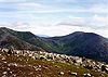 Categories:
- Munros
- Marilyns of Scotland
- Mountains and hills of the Southern Highlands
- Mountains and hills of Perth and Kinross
- Mountains and hills of Aberdeenshire


Wikimedia Foundation. 2010.