- Manchester (Wythenshawe) Aerodrome
-
Coordinates: 53°24′36″N 2°16′48″W / 53.4099°N 2.2801°W
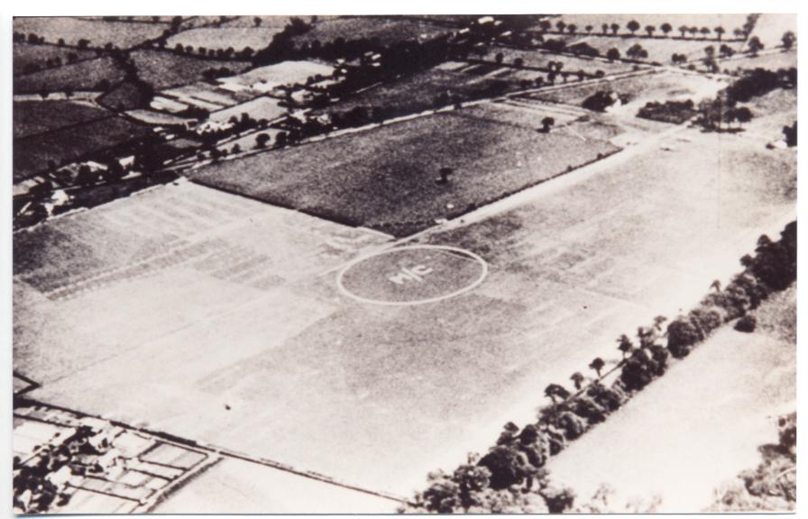
 Wythenshawe Aerodrome in 1929 looking north-east. The small hangar is at top right. Wythenshawe Road slants down from centre right. 'M/C' in the middle of the airfield indicates 'Manchester' to pilots. The lane going across the top right corner is now Rackhouse Road.
Manchester (Wythenshawe) Aerodrome also known locally as Rackhouse Aerodrome was the first airfield built to serve, temporarily, as Manchester's municipal aerodrome.
Contents
Construction and facilities
 Street scene in Rackhouse area in Wythenshawe, 26 September 2010. No sign remains that there was an airport here.
Following a campaign by interested people, Manchester's council began to realise that Manchester needed a permanent airport. Four fields at Rackhouse Farm, which were part of a large area that had been bought from Lord Egerton of Tatton by Manchester Corporation, and mainly intended for use as local authority housing, were chosen in early 1929 for use as Manchester's municipal aerodrome, until the new permanent Barton Airport, near Eccles was built.
The airfield's site was within the fork of Wythenshawe Road and Sale Road, just west of the intersection with today's Princess Parkway and just north of Wythenshawe Park. Hedges were grubbed out, some ground was levelled, and a barn was converted for use as a hangar capable of housing one light aircraft. A country lane which is now Rackhouse Road ran along its east edge.
A farmhouse became the administration building. Temporary fuel pumps were installed.[1]
The north-eastern field (seen dark-coloured on the adjacent photograph) was not made usable for aircraft operations. The only navigational help to pilots to identify the aerodrome were the letters 'M/C' in white, within a large circle. No airfield lighting or radio facilities were provided.[2]
History
The first use of the airfield by an aircraft was on 2 April 1929.
The city's application for an aerodrome licence was dated 13 April 1929, and called the place "Wythenshawe, in the parish of Northenden, in the rural district of Bucklow, in the County of Chester".
The airfield was mainly used for private and club flying. Northern Air Lines (Manchester) Ltd based several aircraft here, their two-seat De Havilland DH.60 Moths being available for charter at one shilling per mile. The Lancashire Aero Club, based at Woodford Aerodrome, regularly sent one of their training aircraft to Wythenshawe, for the convenience of local members.
On 22 April 1929 the Lord Mayor of Manchester and a civic party flew from the aerodrome to Croydon Airport to collect Wythenshawe Aerodrome's temporary operating licence.
An 'Air Pageant' was held on 22 June 1929, attracting many aircraft and large crowds of interested Mancunian spectators.[3]
On 1 January 1930 the aerodrome became redundant as Barton Airport opened.
On 19 June 1930 was the last recorded flight from Wythenshawe Airport.
In 1931, Manchester city's boundaries were extended southwards, and after that the site was in Manchester and Lancashire.
From the early 1930s Manchester Corporation built houses over the area for social housing.
References
Notes
- ^ Scholefield 2004, pp. 222–223
- ^ Scholefield 2004, p. 222
- ^ Scholefield 2004, p. 223
Bibliography
Categories:- Defunct airports in England
- History of Manchester

Wikimedia Foundation. 2010.