Ovington, Norfolk

Ovington, Norfolk

Coordinates: 52°35′10″N 0°50′24″E / 52.58621°N 0.84011°E / 52.58621; 0.84011

Ovington
The church of St John the Evangelist - geograph.org.uk - 706467.jpg
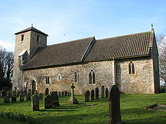
John the Evangelist, Ovington
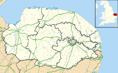
Ovington is located in Norfolk
Ovington

 Ovington shown within Norfolk
Area  6.44 km2 (2.49 sq mi)
Population 239 
    - Density  37 /km2 (96 /sq mi)
OS grid reference TF925025
Parish Ovington
District Breckland
Shire county Norfolk
Region East
Country England
Sovereign state United Kingdom
Post town THETFORD
Postcode district IP25
Police Norfolk
Fire Norfolk
Ambulance East of England
EU Parliament East of England
List of places: UK • England • Norfolk

Ovington is a civil parish in the English county of Norfolk. It covers an area of 6.44 km2 (2.49 sq mi) and had a population of 239 in 92 households as of the 2001 census.[1] It is in the district of Breckland.

Clubs

The long established ladies' group, gardener's and bowls clubs are active in Ovington. More recently an Allotment Association has been formed cultivating land behind the church.[2]

Fairs

Ovington holds a Christmas Bazaar in the Village Hall and a summer fete in the grounds surrounding the hall.

Notes

  1. ^ Census population and household counts for unparished urban areas and all parishes. Office for National Statistics & Norfolk County Council (2001). Retrieved 20 June 2009.
  2. ^ www.ovallot.org.uk Ovington Allotment Association

Wikimedia Foundation. 2010.

Игры ⚽ Нужна курсовая?

Look at other dictionaries:

  • Ovington — may refer to: Places Ovington, County Durham Ovington, Essex Ovington, Hampshire Ovington, Norfolk Ovington, Northumberland People Earle Ovington American inventor Mary White Ovington American civil rights activist …   Wikipedia

  • Ovington, Essex — Ovington is a small village in Essex, England. The village is situated about three miles (5 km) from the village of Clare. It consists of Ovington hall, St. Mary s Church, and a few houses. Its a pretty place, with the air traffic of Ridgewell… …   Wikipedia

  • Norfolk — Geografie Status: Zeremonielle und Verwaltungsgrafschaft Region: East of England Fläche: 5.372 km² Verwalt …   Deutsch Wikipedia

  • Croxton, Norfolk — Coordinates: 52°26′42″N 0°45′36″E / 52.4450°N 0.7600°E / 52.4450; 0.7600 …   Wikipedia

  • Merton, Norfolk — Coordinates: 52°33′14″N 0°48′42″E / 52.554°N 0.8116°E / 52.554; 0.8116 …   Wikipedia

  • Narborough, Norfolk — Coordinates: 52°40′56″N 0°34′57″E / 52.682136°N 0.582493°E / 52.682136; 0.582493 …   Wikipedia

  • List of civil parishes in Norfolk — This is a list of civil parishes in the county of Norfolk, England. It is broken down by the seven local authority districts that make up the county.BrecklandBreckland is entirely parished, and comprises the following parishes:*Ashill… …   Wikipedia

  • List of places in Norfolk — This is a list of cities, towns and villages in the ceremonial and shire county of Norfolk, England. See the list of places in England for places in other counties. Contents Top 0–9 A B C D E F G H I J K L M N O P Q R S T U V W X Y Z NOTOC A*Acle …   Wikipedia

  • Wayland, Norfolk — Wayland is an area in the district of Breckland within the English county of Norfolk. It is situated approximately 20 miles west of Norwich [ [http://www.wayland tourism.org.uk/visitorsguide.htm A Visitors Guide ] ] .The area is a historic… …   Wikipedia

  • George B. Chambers — ummaryGeorge Bennet Chambers (born early 1881 in Ealing, London) was an English vicar, social activist and author (writing as GB Chambers). Following a long career in the Church of England, he became the vicar of Carbrooke Church in Norfolk. An… …   Wikipedia

Share the article and excerpts

Direct link
Do a right-click on the link above
and select “Copy Link”