- Oxbow Regional Park
-
Oxbow Regional Park 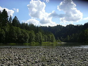
Sandy River in Oxbow Park during summerType Regional park Location near Springdale, Multnomah County, Oregon Coordinates 45°29′42″N 122°17′17″W / 45.4951206°N 122.2881457°WCoordinates: 45°29′42″N 122°17′17″W / 45.4951206°N 122.2881457°W[1] Area 1,200 acres (490 ha) Operated by Metro regional government Oxbow Regional Park is a 1,200-acre (4.9 km2) natural area park located ten miles (16 km) southeast of Troutdale along the Sandy River in the U.S. state of Oregon. Owned and operated by Metro regional government, it hosts a yearly festival celebrating salmon.
Contents
Recreation
The park offers a wide variety of activities, including swimming, boating, fishing, horseback riding, and hiking. Fifteen miles of hiking trails lead through an ancient forest with centuries-old trees and ridges and ravines carved by volcanic and glacial flows. Metro, the park's managing body, leads ancient forest walks, animal tracking workshops, and wildflower and mushroom identification classes. Year-round camping is available in the park's 67-site developed campground.[2][3]
Oxbow also offers opportunities to see wildlife and animal tracks. The area’s natural habitat makes an ideal home for wildlife such as mink, beaver, raccoon, fox, deer, osprey, elk, black bear, and cougar. In order to avoid confrontation with wildlife, pets are not allowed in the park.[2]
Salmon Festival
Oxbow Regional Park hosts the annual Salmon Festival, celebrating the return of the Chinook salmon while educating the public about the importance of intact, functional aquatic ecosystems, protection of native salmon and their habitat, and how fully functioning aquatic ecosystems can have a positive and important influence on human quality of life.[4] One of the longest running and most recognized salmon festivals on the West Coast, the Oxbow Salmon Festival has evolved into a popular conservation educational event. The two-day event draws up to 10,000 visitors who can see spawning salmon; enjoy music, food, art, storytelling, and a fish maze; and encounter a variety of traditional activities and cultural exhibits at Wy-Kan-Ush-Pum village hosted by the fishing tribes of the Columbia Basin, including the Nez Perce, Umatilla, Yakama, and Warm Springs tribes.[4][5]
See also
- Blue Lake Regional Park
- Cooper Mountain Nature Park
References
- ^ "Oxbow Regional Park". Geographic Names Information System. United States Geological Survey. May 26, 2004. http://geonames.usgs.gov/pls/gnispublic/f?p=106:3:2860626032767296::NO::P3_FID:1125102. Retrieved January 10, 2009.
- ^ a b Metro: Oxbow Regional Park
- ^ Metro: Camping at Oxbow
- ^ a b USDA Forest Service NatureWatch Project
- ^ TravelOregon.com - 24th Annual Salmon Festival
External links
Protected Areas of Oregon Federal State Arcadia Beach • Bob Straub • Bradley • Cape Kiwanda • Cape Lookout • Cape Meares • Clay Myers at Whalen Island • Del Rey Beach • Ecola • Elmer Feldenheimer • Fishing Rock • Fort Stevens • Gearhart Ocean • Haystack Hill • Hug Point • John Yeon • Manhattan Beach • Munson Creek Falls • Neahkahnie–Manzanita • Nehalem Bay • Oceanside Beach • Oswald West • Rockaway Beach • Sunset Beach • Sunset Highway Forest • Symons • Tolovana Beach • Tolovana Beach • Twin Rocks • Wilson River Highway Forest
Agate Beach • Alsea Bay • Beachside • Beaver Creek • Beverly Beach • Boiler Bay • Carl G. Washburne • Collins Creek • D River • Darlingtonia • Devils Lake • Devils Punch Bowl • Driftwood Beach • Ellmaker • Fogarty Creek • Gleneden Beach • Governor Patterson • H.B. Van Duzer • Heceta Head Lighthouse • Jessie M. Honeyman • Joaquin Miller Forest • L. Presley & Vera C. Gill • Lost Creek • Muriel O. Ponsler • Neptune • Neskowin Beach • Ona Beach • Otter Crest • Pritchard • Roads End • Rocky Creek • San Marine • Seal Rock • Smelt Sands • South Beach • Stonefield Beach • Tokatee Klootchman • W. B. Nelson • Whale Watching • Yachats • Yachats Ocean Road • Yaquina Bay
Albert H. Powers • Alfred A. Loeb • Arizona Beach • Bandon • Bolon Island Tideways • Bullards Beach • Cape Arago • Cape Blanco • Cape Sebastian • Conde B. McCullough • Coquille Myrtle Grove • Crissey Field • Elk Creek Tunnel Forest • Face Rock • Floras Lake • Geisel Monument • Golden and Silver Falls • Harris Beach • Hoffman • Humbug Mountain • Hutchinson • Maria C. Jackson • McVay Rock • Ophir • Otter Point • Paradise Point • Pistol River • Port Orford Cedar Forest • Port Orford Heads • Samuel H. Boardman • Seven Devils • Shore Acres • Sisters Rock • Sunset Bay • Sweet Myrtle • Umpqua • Umpqua Lighthouse • Umpqua Myrtle • William M. Tugman • Winchuck • Yoakam Point
Banks–Vernonia • Bonnie Lure • Government Island • L. L. "Stub" Stewart • Mary S. Young • Milo McIver • Tryon Creek • Willamette Stone
Ainsworth • Benson • Bonneville • Bridal Veil Falls • Crown Point • Dabney • Dalton Point • George W. Joseph • Guy W. Talbot • Historic Columbia River Highway • John B. Yeon • Koberg Beach • Lang Forest • Lewis and Clark • Lindsey Creek • Mayer • McLoughlin • Memaloose • Multnomah Falls • Portland Women's Forum • Rocky Butte • Rooster Rock • Seneca Fouts • Shepperd's Dell • Sheridan • Starvation Creek • Viento • Vinzenz Lausmann • Wyeth • Wygant
Alderwood • Bald Peak • Blachly Mountain Forest • Bowers Rock • Cascadia • Champoeg • Detroit Lake • Dexter • Elijah Bristow • Erratic Rock • Fall Creek • Fort Yamhill • Holman • Jasper • Lowell • Luckiamute • Maples • Maud Williamson • Molalla River • North Santiam • Sarah Helmick • Silver Falls • State Capitol • Thompson's Mills • Washburne • Willamette Mission
Ben Hur Lampman • Canyon Creek Forest • Casey • Collier Memorial • Illinois River Forks • Jackson F. Kimball • Joseph H. Stewart • Klamath Falls – Lakeview Forest • OC&E Woods Line • Prospect • Rough and Ready Forest • Stage Coach Forest • TouVelle • Tub Springs • Valley of the Rogue • Wolf Creek Inn
Cline Falls • Deschutes River • Dyer • Elliott Corbett • La Pine • Ochoco • Peter Skene Ogden • Pilot Butte • Prineville Reservoir • Redmond–Bend Juniper • Sisters • Smith Rock • The Cove Palisades • Tumalo • White River Falls
Bates • Battle Mountain Forest • Blue Mountain Forest • Booth • Catherine Creek • Chandler • Clyde Holliday • Crooked Creek • Deadman's Pass • Emigrant Springs • Farewell Bend • Fort Rock • Fort Rock Cave • Frenchglen Hotel • Goose Lake • Hat Rock • Hilgard Junction • Kam Wah Chung • Lake Owyhee • Minam • Ontario • Pete French Round Barn • Red Bridge • Succor Creek • Sumpter Valley Dredge • Ukiah–Dale Forest • Unity Forest • Unity Lake • Wallowa Lake • Wallowa Lake Highway Forest • Wallowa River
Bridge Creek • Dean Creek • Denman • E.E. Wilson • Elkhorn • Fern Ridge • Irrigon • Jewell Meadows • Klamath • Ladd Marsh • Lower Deschutes • Phillip W. Schneider • Prineville • Riverside • Sauvie Island • Snake River Islands • Summer Lake • Wenaha • White River • Willow Creek
Regions Portland metroBlue Lake • Cooper Mountain • Glendoveer • Howell • Oregon Zoo • Oxbow • Smith and Bybee • Mount Talbert
Cities PortlandForest Park • Washington Park
Categories:- Parks in Oregon
- Parks in Multnomah County, Oregon
- Metro (Oregon regional government)

Wikimedia Foundation. 2010.