- Cutler Park
-
Cutler Park Reservation Massachusetts State Park Country United States State Massachusetts Region Norfolk County Municipality Needham and Dedham Location Great Plain Av, Dedham - elevation 89 ft (27 m) - coordinates 42°16′59″N 71°11′51″W / 42.28306°N 71.1975°W Area 1.09375 sq mi (3 km2) Biome freshwater marsh 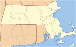
 Location of Cutler Park
Website: Cutler Park (DCR) U.S. Geological Survey Geographic Names Information System: Cutler Park Cutler Park is a 700-acre (2.8 km2) park in Needham, Massachusetts that runs between Route 128/I-95 and the Charles River. The park is managed by the Department of Conservation and Recreation (DCR).
Description
The park contains trails suitable for a variety of activities including walking, hiking, bird watching, mountain biking, and cross country skiing. It contains the largest remaining freshwater marsh on the middle Charles River, and includes a boardwalk through a cattail marsh out onto an island.
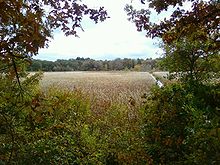 The southern end of Cutler Park, showing a boardwalk through the marsh.
Along the west side of Cutler Pond remains the imprint where soil was removed in the 19th century to fill the area now known as the Back Bay in Boston. An extension of the railroad was added so the soil could be transported into Boston. Some of the old tracks are visible near the north entrance of the park on Kendrick Street.
External links
- http://www.mass.gov/dcr/parks/metroboston/cutlerPark.htm
- http://www.newtonconservators.org/23cutler.htm
- http://www.nemba.org/ridingzone/Cutler_Park.html
Protected Areas of Massachusetts Federal Adams · Boston · Boston African American · Frederick Law Olmsted · John Fitzgerald Kennedy · Longfellow House · Lowell · Minute Man · New Bedford Whaling · Salem Maritime · Saugus Iron Works · Springfield Armory
Appalachian National Scenic Trail · Boston Harbor Islands National Recreation Area · Cape Cod National Seashore · Stellwagen Bank National Marine Sanctuary · Waquoit Bay National Estuarine Research Reserve · West Hill Dam
Assabet River · Great Meadows · Mashpee · Massasoit · Monomoy · Nantucket · Nomans Land · Oxbow · Parker River · Silvio O. Conte · Thacher Island
State Alewife Brook · Ames Nowell · Ashland · Bash Bish Falls · Blackstone River and Canal Heritage · Borderland · Boston Harbor Islands · Bradley Palmer · C. M. Gardner · Callahan · Castle Island State Park · Chicopee Memorial · City Square · Clarksburg · Cochituate · Connecticut River Greenway · Demarest Lloyd · Dighton Rock · Dunn · Ellisville Harbor · Fall River Heritage · Gardner Heritage · Great Brook Farm · Halibut Point · Hampton Ponds · Holyoke Heritage · Hopkinton · Lake Lorraine · Lake Wyola · Lawrence Heritage · Lowell Heritage · Lynn Heritage · Massasoit · Maudslay · Moore · Mount Holyoke Range · Natural Bridge · Nickerson · Pearl Hill · Pilgrim · Quinsigamond · Robinson · Roxbury Heritage · Rutland · Skinner · South Cape Beach · Wahconah Falls · Webb Memorial · Wells · Western Gateway Heritage · Whitehall · Wompatuck
State Parks:
ReservationsBeaver Brook · Belle Isle Marsh · Blue Hills · Breakheart · Charles River · Chestnut Hill · Cutler · Dorchester Shores · Elm Bank · Fort Phoenix · Hammond Pond · Hemlock Gorge · Horseneck Beach · Jug End · Lynn Shore · Middlesex Fells · Mount Everett · Mount Greylock · Mount Sugarloaf · Mount Tom · Myles Standish · Mystic River · Nahant Beach · Nantasket Beach · Nasketucket Bay · Neponset River · Pope John Paul II · Purgatory Chasm · Quincy Quarries · Quincy Shore · Revere Beach · Rumney Marsh · Salisbury Beach · Sandy Point · Scusset Beach · Stony Brook · Upper Charles River · Wachusett Mountain · Walden Pond · Weymouth · Wilson Mountain
State Parks:
OtherAppalachian Trail · Ashuwillticook Rail Trail · Cape Cod Rail Trail · Fort Revere · Lake Dennison Recreation Area · Lower Neponset River Trail · Nashua River Rail Trail · Norwottuck Rail Trail · Quabbin Reservoir · Southwest Corridor Park · Squantum Point Park · Streeter Point Recreation Area · Sudbury Reservoir · Wachusett Reservoir · Ware River Watershed Area
Barnstable · Beartown · Brimfield · Chester-Blandford · DAR · Douglas · Erving · F. Gilbert Hills · Federated Women's Club · Freetown-Fall River · Georgetown Rowley · Granville · Harold Parker · Kenneth Dubuque Memorial · Leominster · Lowell-Dracut-Tyngsboro · Manuel F. Correllus · Mohawk Trail · Monroe · Mount Grace · Mount Washington · Myles Standish · October Mountain · Otter River · Pittsfield · Sandisfield · Savoy Mountain · Shawme-Crowell · Spencer · Tolland · Upton · Wendell · Willard Brook · Willowdale · Windsor
Agawam Lake · Agawam Mill Pond · Ashby · Ashfield Hawley · Attitash · Ayer Game Farm · Baddacook Pond · Bakers Pond · Bay Circuit Trail · Bearse Pond · Becket · Bennett · Birch Hill · Black Brook · Blackstone / West River · Bolton Flats · Boxboro Station · Brayton Point Salt Marsh · Breakneck Brook · Brewer Brook · Bullock Ledge · Burrage Pond · Canoe River · Catamount · Chalet · Chase Garden Creek Salt Marsh · Childs River · Chockalog Swamp · Church Homestead · Clapps Pond · Clinton Bluff · Concord River · Connecticut River · Cook Pond · Copicut · Coy Hill · Crane Pond · Cummington · Cusky Pond · Dartmoor Farm · Darwin Scott Memorial · Day Mountain · Deerfield River · Dogfish Bar Beach Coastal · Dolomite Ledges · Dunstable Brook · E. Kent Swift · Eagle Island · East Mountain · Eastham Salt Marsh · Elbow Meadow · English Salt Marsh · Eugene D. Moran · Facing Rock · Fairfield Brook · Farmington River · Fish Brook · Fisherville Pond · Fisk Forestdale Lot · Fisk Meadows · Five Mile River · Flagg Swamp · Flint Pond · Four Chimneys · Fox Den · Fox Island Salt Marsh · Frances A. Crane · Freetown Swamp · George L. Darey Housatonic Valley · Glen Echo Lake · Gosnold · Grassy Pond (Dennis) · Grassy Pond (Plymouth) · Green River (Franklin County) · Green River (Berkshire County) · Greenfield River · Halfway Pond · Hamilton · Hancock · Harlow / Cooks Pond · Haskell Swamp · Hauk Swamp · Hawksnest State Park · Hawley · Head Of The Plains · Herman Covey · High Ridge · Hinsdale Flats · Hiram H. Fox · Hockomock Swamp · Hog Pond Lot · Honey Pot · Hoosatonic River · Hoosic River · Hop Brook · Housatonic River · Hubbard Brook · Hunting Hills · Hyannis Ponds · Ipswich River · John J. Kelly · Jug End Fen · Jug End · Kampoosa Fen · Katama Plains · Knops Pond · Konkapot River · Lackey Pond · Lake Lorraine · Lake Rohunta · Lake Snipatuit · Lake Warner · Lanesboro · Lawrence Brook · Lawrence Pond Lot · Leadmine · Leyden · Lilly Pond · Little Alum Pond · Long Sought For Pond · Maple Hill · Maple Springs · Martha Deering · Martin H. Burns · Mascuppic Lake · Mashpee Pine Barrens · Mashpee Pond Lot · Mashpee River · Massachusetts Military Reservation · Mckinstry Brook · Meetinghouse Swamp · Merrill Pond · Miacomet Heath · Mill River · Millers River · Mine Brook · Montague Plains · Montague · Moose Brook · Moose Brook · Moose Hill · Mossy Pond · Mount Watatic Reservation · Mt. Esther · Mt. Toby Highlands · Mt. Toby · Mt. Tom · Muddy Brook · Muddy Pond · Mulpus Brook · Nashua River · Natty Brook · Nemasket River · Nissitissit River · Noquochoke · Nordeen Marsh · North Brookfield · North Shore Salt Marsh · Northboro · Oakham · Olivers Pond · Orange · Otis · Packard Pond · Palmer · Pantry Brook · Pauchaug Brook · Peru · Peterson Swamp · Phillipston · Podunk Marsh · Poland Brook · Popple Camp · Popponesset Beach · Poutwater Pond · Powell Brook · Prince River · Provincetown Route 6 Corridor · Purchade Brook · Quaboag · Quacumquasit · Quag Pond Bog · Quashnet River · Quashnet Woods State Reservation · Quinapoxet River · Quinsigamond Marsh · Quisset · Raccoon Hill · Rainbow Beach · Red Brook · Richardson · Robbins Pond · Rochester · Rocky Gutter · Rowe · Salisbury Salt Marsh · Salisbury Salt Marsh · Sandwich Game Farm · Sandy Pond · Satan's Kingdom · Savage Hill · Savoy · Sawmill River · Scorton Creek Coastal · SE Mass Bioreserve · Sevenmile River · Shattuck Brook · Sheperds Island · Shubael Pond · Sibley Brook · Sly Pond · South Barrier Beach · South Meadow Pond · South Shore Salt Marsh · South Triangle Pond · Southampton · Southwick · Spectacle Pond · Springhill Lot · Sputtermill Pond · Squannacook River · Stafford Hill · Sudbury River · Sunderland Islands · Taconic Mountain · Taunton River · Taunton River · Tekoa Mountain · Thad Ellis · Thayer Pond · Three Mile Pond · Townsend · Townsend Hill · Trapfall Brook · Triangle Pond · Tully Brook · Tully Mountain · Tully River · Wakeby Pond · Wales · Walnut Hill · Ware River · Warwick · Wendell · West Meadows · Westboro · Westfield River · Westfield · Weymouth Back River · Whately Great Swamp · Whately Ponds · Whately · Wilbraham Game Farm · William Forward · Williams River · Williamsburg · Winimusset · Wolf Swamp ·Billingsgate Island · Carr Island · E. Howe Forbush · Egg Rock · Grace A. Robson · J.C. Phillips · Knight · Penikese Island · Ram Island (Salisbury) · Ram Island (Mattapoisett) · Susan B. Minns · Tarpaulin Cove · Watatic Mountain ·Private Roger and Virginia Drury Preserve · Tatkon Preserve · McElwain-Olsen Preserve · Reed Brook Preserve · Hawley Bog Preserve · Stacy Mountain Preserve · Greene Swamp Preserve · Black Pond Bog Nature Preserve · Halfway Pond Island Preserve · Grassy Pond Preserve · Boat Meadow Preserve · Sandy Neck Preserve · Hockomock Swamp · David H. Smith Preserve and Fire Trail · Hoft Farm Preserve · Katama Plains Preserve · Francis Newhall Woods Nature and Wildlife Preserve · Miacomet Moors Preserve · Homer-Watcha Preserve ·
Agassiz Rock · Appleton Farms · Appleton Farms Grass Rides · Ashintully Gardens · Bartholomew's Cobble · Bear's Den · Bear Swamp · Colonel John Ashley House · Francis William Bird Park · Eleanor Cabot Bradley Estate · Bridge Island Meadows · Brooks Woodland Preserve · William Cullen Bryant Homestead · Cape Poge Wildlife Refuge · Cedariver · Castle Hill · Chapel Brook · Charles River Peninsula · Chase Woodlands · Chesterfield Gorge · Coolidge Reservation · Copicut Woods · Cormier Woods · Coskata-Coatue Wildlife Refuge · Crane Beach · Crane Wildlife Refuge · Crowninshield Island · Dexter Drumlin · Dinosaur Footprints · Doane's Falls · Doyle Reservation · Dry Hill · East Over Reservation · Elliott Laurel · Field Farm · Fork Factory Brook · Glendale Falls · Goose Pond Reservation · Greenwood Farm · Halibut Point Reservation · Hamlin Reservation · Holmes Reservation · Governor Hutchinson's Field · Jacobs Hill · Little Tom Mountain · Long Hill · Long Point Wildlife Refuge · Lowell Holly Reservation · Lyman Reserve · Malcolm Preserve · Mashpee River Reservation · McLennan Reservation · Medfield Meadow Lots · Medfield Rhododendrons · Menemsha Hills · Misery Islands · Mission House · Monument Mountain · Moose Hill Farm · Mount Ann Park · Mountain Meadow Preserve · Mytoi · Naumkeag · Noanet Woodlands · Noon Hill · Norris Reservation · North Common Meadow · Norton Point Beach · Notchview · Old Manse · Old Town Hill · Peaked Mountain · Pegan Hill · Peters Reservation · Petticoat Hill · Pierce Reservation · Pine and Hemlock Knoll · Powisset Farm · Questing · Quinebaug Woods · Ravenswood Park · Redemption Rock · Rock House Reservation · Rocky Narrows · Rocky Woods · Royalston Falls · Shattuck Reservation · Signal Hill · Slocum's River Reserve · Stavros Reservation · The Stevens-Coolidge Place · Swift River Reservation · Tantiusques · Tully Lake Campground · Two Mile Farm · Tyringham Cobble · Ward Reservation · Wasque · Weir Hill · Weir River Farm · Westport Town Farm · Whitney and Thayer Woods · World's End ·
Arcadia · Broad Meadow Brook · Broadmoor · Drumlin Farm · High Ledges · Ipswich River · North River · Pleasant Valley · Stony Brook · Wachussett Meadow · Wellfleet Bay
OtherConcord Land Conservation Trust · Harvard Forest · Lincoln Land Conservation Trust ·
Executive Office of Energy and Environmental Affairs (Massachusetts) Categories:- Charles River
- Massachusetts state parks
- Massachusetts natural resources
- Parks in Norfolk County, Massachusetts


Wikimedia Foundation. 2010.