- Hodod
-
Hodod
Hadad, Kriegsdorf— Commune — 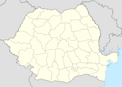
 Hodod
HododCoordinates: 47°24′N 23°2′E / 47.4°N 23.033°E Country  Romania
County Satu Mare County Population (2002)[1] 3,199 Time zone EET (UTC+2) – Summer (DST) EEST (UTC+3)  Location of Hodod in Satu Mare County
 Hodod, Hungarian Reformed church
 Nadişu, Kloten Utca
 Giurtelecu, Romanian Orthodox church
 Lelei
Lelei Lelei, wooden church
Hodod (Hungarian: Hadad, Hungarian pronunciation: [hɒdɒd]; German: Kriegsdorf) is a commune of 3,209 inhabitants situated in Satu Mare County, Romania. It is composed of four villages:
Romanian Hungarian German[2] Giurtelecu Hododului Hadadgyőrtelek Wüst Jörgen, Georgius Hodod Hadad Kriegsdorf Lelei Lele Lellen Nadişu Hododului Hadadnádasd Ungarisch Rohrdorf, Rohrfeld Contents
Geography
The municipality of Hodod lies in the extreme southeast of the county Satu Mare and borders in the west to the municipality Bogdand, in the north to the Maramures county and in the east and south by the Sălaj county. The municipality is located in the hills of Codru, 10 km west of Cehu Silvaniei and 70 km south of Satu Mare, the capital of the Satu Mare county.
History
Until 1940
Hodod is mentioned since 1210, Nadişu Hododului since 1205, Lelei since 1330, Giurtelecu Hododului since 1378.
Hodod belonged to the Kingdom of Hungary and was part of the Principality of Transylvania. In 1399, a castle is mentioned when the village belonged to the family Kusalyi Jakcs. Hodod gained city status in 1482.
Hodod was given by King Rudolf II of Habsburg to the family Wesselényi, to whom it belongs to the 20th century. The castle was destroyed in the early eighteenth century. After the rebellion of Francis II Rákóczi, the town was taken from the family Wesselényi.
The Wesselényi family built a large castle in Baroque style. After the outbreak of the plague, the immigration of German settlers was promoted. From 1744 to 1751 Baron Franz Wesseleny called 30 families from Baden-Durlach and Switzerland to his property in Kriegsdorf (Hadad). In subsequent years, more immigrants came from German-speaking regions to Kriegsdorf.[3][4]. In 1880 Kriegsdorf counted 479 German inhabitants.
After the Austro-Hungarian compromise of 1867 the Austrian Empire, and the Principality of Transylvania, disappear. In 1876 the Kingdom of Hungary is divided into provinces. Hodod is now part of the district Szilagyi (Szilagyi vármegye'). At the end of World War I, the Austro-Hungarian Empire disappears and the city is part of Greater Romania in the Treaty of Trianon. Hodod is now part of the district Sălaj.1940-1945
Hodod in 1940 following the Second Vienna Award, annexed by Hungary until 1944.
In May 1944, the Jews were collected in the ghetto of Satu Mare. On May 19, 22, 26, 29, 30, 31 and June 1 of that year, they were deported to Auschwitz[5][6][7].The fate of the Roma is little is known. This is partly due to the fact that the Roma, in comparison with the Jews, were poorly organized[8][9].
With the retreat of the German army in 1944, many Germans left Hodod. In 1945, 43 Germans were deported to the Soviet Union[10].After 1945
After the Second World War Hodod, with the Treaty of Paris, became Romanian again.
In the administrative reform of the country in 1968, the city became part of the Satu Mare county to which it belongs so far.During the communist regime, especially in the 1980s, many Germans emigrated.
Demographics
Ethnic groups (2002 census)[11]
- Hungarians: 2166 (67,70%)
- Romanians: 907 (28.35%)
- Romani people: 79 (2.46%)
- Germans: 46 (1.43%)
Inhabitants per village (census 2002)[11]:
- Giurtelecu Hododului: 816
- Hodod: 912
- Lelei: 662
- Nadişu Hododului: 809
Religion
In 2002, the religious composition of the municipality is as follows[11]:
- Reformed: 60.26%
- Orthodox: 27.57%
- Baptist: 7.87%
- Pentecostal: 1.71%
- Catholic: 0.84%
- Seventh-day Adventist: 0.56%
Language
The official language is Romanian. In Hodod, Nadişu and Lelei is predominantly Hungarian spoken. Giurtelecu speaks mainly in Romanian. The Roma talk Romani (language of the Roma, gypsies). A small minority speaks German.
Ethnic minority groups (Hungarians, Swabians) often feel in the first place to their ethnicity and, second, Romanian. In villages with predominantly Hungarian population it is polite to Hungarians using Hungarian place names (Hadad Hadadgyőrtelek, Hadadnádasd, Lele). Speaking to Romanians the use of Romanian place names is polite (Hodod, Lelei, Giurtelecu Hododului, Nadişu Hododului). This applies also to titles such as "mayor" (Hungarian: polgármester; Romanian: Primar).
In terms of foreign languages, a part of the population speaks English, French, and German. Historically, French was the leading language for the study. Nowadays is't so that the elderly in Romania speak French and youngsters English.
Politics
The Hodod City Council has 11 Councillors. At the time of the Romanian municipal elections of June 2008, Francisc Balog (UDMR) was elected as Mayor.[12]
Municipal elections 2008[13] Party Number of Councillors Democratic Union of Hungarians in Romania
(Uniunea Democrată Maghiară din România, UDMR)
7 National Liberal Party
(Partidul Naţional Liberal, PNL)
1 New Generation Party – Christian Democratic
Partidul Noua Generaţe -Creştin Democrat
1 Social Democratic Party
(Partidul Social Democrat, PSD)
1 Hungarian Civic Union
(Partidul Civic Magiar - Magyar Polgári Párt)
1 Not all parties are nationally operating parties.
Education
 Lelei, school
In Hodod is an elementary school[14]. In Nadişu, Giurtelecu and Lelei are dependances.
Romanian children visit from their 6th until their 14th year elementary education.
The Romanian educational system is as follows:- Scoala Primara şi gimnaziala - elementary school
- Liceu - secondary education
- Invăţământ Superior - high school
Economy
 Hodod, market
Agriculture
The economy of the municipality is based on agriculture (arable, livestock and beekeeping).
Market
In Hodod is every first Monday of the month a large market.
Historic sites and monuments
 Hodod, Jewish cemetery
Castles
- Hodod, Wesselényi Castle, one of the landmarks of the Baroque style in the district of Satu-Mare. Eighteenth century[15].
- Hodod, Degenfeld castle. Eclectic Architecture. Nineteenth century[15].
Church Buildings
- Hodod, Evangelical Lutheran Church. Eighteenth century[16][17].
- Hodod, Reformed Church. Gothic architecture. Fifteenth century, classified historic monument[16].
- Nadişu Hododului, Reformes church. Fifteenth century, classified historic monument[16].
- Giurtelecu Hododului, Orthodox church[16].
- Lelei, wooden orthodox church of the Holy Archangels. 1870, classified historic monument[16].
- Lelei, wooden protestant church. Built 1783 - 1788[16][18].
Cemeteries
East of Hodod, hidden between the fields and groves, there is a Jewish cemetery[5]. Also in Nadişu Hododului[6] en Lelei[7] are Jewish cemeteries. In Hodod there is a German cemetery[19]. In this cemetery is a memorial plaque with the names of 44 victims of the First World War (1914-1918).
Natives
- Béla Kun (1886-1938), Communist revolutionary
- Virgil Măgureanu (1941-), intelligence agency chief
References
- ^ Romanian census data, 2002; retrieved on March 1, 2010
- ^ Exonyme - Vergessene Ortsnamen
- ^ Heimatortsgemeinschaft Kriegsdorf-Hadad, The history of Hadad
- ^ Zeitschrift für Siebenbürgische Landeskunde
- ^ a b IAJGS International Jewish Cemetery Project (Hodod)
- ^ a b IAJGS International Jewish Cemetery Project (Nadişu Hododului)
- ^ a b IAJGS International Jewish Cemetery Project (Lelei)
- ^ Non-Jewish Holocaust Victims
- ^ Porajmos (Gypsy persecution)
- ^ Heimatortsgemeinschaft Kriegsdorf-Hadad, migration Germans
- ^ a b c Romanian census data, 2002; retrieved on March 22, 2010
- ^ Internet-site municipality Hodod
- ^ Municipal elections 2008
- ^ List of Romanian schools
- ^ a b List of Romanian castles
- ^ a b c d e f Database Romanian churches
- ^ Heimatortsgemeinschaft Kriegsdorf-Hadad, Lutheran Church
- ^ Wooden churches in Satu Mare
- ^ Heimatortsgemeinschaft Kriegsdorf-Hadad, German cemetery
External Links
Coordinates: 47°24′N 23°02′E / 47.4°N 23.033°E
Satu Mare County, Romania Cities 
Towns Ardud · Negreşti-Oaş · Tăşnad · Livada
Communes Acâş · Agriş · Andrid · Apa · Bătarci · Beltiug · Berveni · Bixad · Bârsău · Bogdand · Botiz · Călineşti-Oaş · Cămărzana · Cămin · Căpleni · Căuaş · Cehal · Certeze · Ciumeşti · Craidorolţ · Crucişor · Culciu · Doba · Dorolţ · Foieni · Gherţa Mică · Halmeu · Hodod · Homoroade · Lazuri · Medieşu Aurit · Micula · Moftin · Odoreu · Oraşu Nou · Păuleşti · Petreşti · Pir · Pişcolt · Pomi · Porumbeşti · Racşa · Sanislău · Santău · Săcăşeni · Săuca · Socond · Supur · Tarna Mare · Terebeşti · Tiream · Târşolţ · Turţ · Turulung · Urziceni · Valea Vinului · Vetiş · Viile Satu Mare · Vama
Categories:- Communes in Satu Mare County


Wikimedia Foundation. 2010.