- Long Beach Township, New Jersey
-
Long Beach Township, New Jersey — Township — Map of Long Beach Township in Ocean County. Inset: Location of Ocean County highlighted in the State of New Jersey.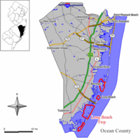 Census Bureau map of Long Beach Township, New Jersey
Coordinates: 39°36′24″N 74°12′32″W / 39.60667°N 74.20889°WCoordinates: 39°36′24″N 74°12′32″W / 39.60667°N 74.20889°W Country United States State New Jersey County Ocean Incorporated March 23, 1899 Government[1] – Type Walsh Act (New Jersey) – Mayor Joseph H. Mancini (2012) Area – Total 22.0 sq mi (57.0 km2) – Land 5.3 sq mi (13.7 km2) – Water 16.7 sq mi (43.2 km2) Elevation[2] 7 ft (2 m) Population (2010)[3] – Total 3,051 – Density 627.3/sq mi (242.2/km2) Time zone Eastern (EST) (UTC-5) – Summer (DST) EDT (UTC-4) ZIP code 08008 Area code(s) 609 FIPS code 34-41250[4][5] GNIS feature ID 0882066[6] Website http://www.longbeachtownship.com Long Beach Township is a Walsh Act Township in Ocean County, New Jersey, United States. As of the United States 2010 Census, the township population was 3,051.
Long Beach Township was incorporated as a township by an Act of the New Jersey Legislature on March 23, 1899, from portions of Eagleswood Township, Little Egg Harbor Township, Ocean Township, Stafford Township, Union Township (now Barnegat Township). Portions of the township were taken to form Barnegat City (March 29, 1904, now Barnegat Light) and Ship Bottom-Beach Arlington (March 3, 1925, now Ship Bottom).[7]
North Beach Haven is a census-designated place and unincorporated area located within Long Beach Township. Other communities within Long Beach Township include the Long Beach Island communities of Beach Haven Crest, Beach Haven Gardens, Beach Haven Inlet, Beach Haven Park, Beach Haven Terrace, Brant Beach, Brighton Beach, Haven Beach, High Bar Harbor, Holgate, Loveladies, North Beach, North Beach Haven, Peahala Park, South Beach Haven, Spray Beach, and the Dunes.
Contents
Geography
According to the United States Census Bureau, the township has a total area of 22.0 square miles (57 km2). 5.3 square miles (14 km2) of it is land and 16.7 square miles (43 km2) of it (75.90% ) is water.
The township is divided into four discontiguous land areas. The most populous, with most of the named places, is located north of Beach Haven and south of Ship Bottom. The Holgate section is south of Beach Haven; most of it is a wildlife preserve. Loveladies and High Bar Harbor form the northernmost, between Harvey Cedars and Barnegat Light. North Beach and Frazier Park north of Surf City and south of Harvey Cedars.
Demographics
Historical populations Census Pop. %± 1930 355 — 1940 425 19.7% 1950 840 97.6% 1960 1,561 85.8% 1970 2,910 86.4% 1980 3,488 19.9% 1990 3,407 −2.3% 2000 3,329 −2.3% 2010 3,051 −8.4% Population 1930 - 1990.[8] As of the census[4] of 2000, there were 3,329 people, 1,664 households, and 1,038 families residing in the township. The population density was 627.3 people per square mile (242.1/km²). There were 9,023 housing units at an average density of 1,700.1 per square mile (656.1/km²). The racial makeup of the township was 98.53% White, 0.24% African American, 0.03% Native American, 0.36% Asian, 0.33% from other races, and 0.51% from two or more races. Hispanic or Latino of any race were 2.10% of the population.
There were 1,664 households out of which 12.3% had children under the age of 18 living with them, 53.5% were married couples living together, 6.4% had a female householder with no husband present, and 37.6% were non-families. 33.8% of all households were made up of individuals and 19.9% had someone living alone who was 65 years of age or older. The average household size was 2.00 and the average family size was 2.50.
In the township the population was spread out with 11.7% under the age of 18, 3.9% from 18 to 24, 17.9% from 25 to 44, 30.0% from 45 to 64, and 36.5% who were 65 years of age or older. The median age was 57 years. For every 100 females there were 90.2 males. For every 100 females age 18 and over, there were 89.2 males.
The median income for a household in the township was $48,697, and the median income for a family was $59,833. Males had a median income of $41,681 versus $31,528 for females. The per capita income for the township was $33,404. About 3.8% of families and 5.1% of the population were below the poverty line, including 7.6% of those under age 18 and 5.8% of those age 65 or over.
Government
Local government
Long Beach Township has been governed under the Walsh Act form of New Jersey municipal government, by a three-member Township Committee, since 1936.[9] Commissioners are elected to serve four-year terms on a concurrent basis in partisan elections, with all current commissioner's terms of office ending on June 30, 2012.[1]
As of 2009[update], the members of the Long Beach Township Commission are Mayor Joseph H. Mancini, Ralph H. Bayard and DiAnne C. Gove.[10][11]
On August 12, 2009, Gove was selected by Republican county committee members to fill the remainder of the term of Daniel Van Pelt in the General Assembly representing the 9th legislative district. Van Pelt had resigned after being arrested on corruption charges. She is not expected to take office until the Assembly returns from recess after the general election on November 3.[12]
Federal, state and county representation
Long Beach Township is in the 3rd Congressional district. New Jersey's Third Congressional District is represented by Jon Runyan (R, Mount Laurel Township). New Jersey is represented in the United States Senate by Frank Lautenberg (D, Cliffside Park) and Bob Menendez (D, Hoboken).
Long Beach Township is in the 9th district of the New Jersey Legislature, which is represented in the New Jersey Senate by Christopher J. Connors (R, Lacey Township) and in the New Jersey General Assembly by DiAnne Gove (R, Long Beach Township) and Brian E. Rumpf (R, Little Egg Harbor Township).[13]
Ocean County is governed by a Board of Chosen Freeholders consisting of five members, elected at large in partisan elections and serving staggered three-year terms of office, with either one or two seats coming up for election each year. As of 2011, Ocean County's Freeholders are Freeholder Director Joseph H. Vicari (Toms River, term ends December 31, 2011), Freeholder Deputy Director Gerry P. Little (Surf City, 2012), John C. Bartlett, Jr. (Pine Beach, 2012), John P. Kelly (Eagleswood Township, 2010) and James F. Lacey (Brick Township, 2013).[14][15]
Education
For grades K through 6, public school students attend the Long Beach Island Consolidated School District, which serves students from Barnegat Light, Harvey Cedars, Long Beach Township, Ship Bottom and Surf City.[16] Schools in the district (with 2008-09 enrollment data from the National Center for Education Statistics[17]) are Ethel Jacobsen School in Surf City with 127 students in grades Kindergarten - 2 and Long Beach Island Grade School in Ship Bottom with 123 students in grades 3 - 6.
Public school students in grades 7 through 12 attend the Southern Regional Middle School (grades 7 and 8) and Southern Regional High School (grades 9 - 12). These schools are part of the Southern Regional School District, which serves the five municipalities in the Long Beach Island Consolidated School District, along with students from Beach Haven, Stafford Township and Ocean Township.[18] Both schools are in Manahawkin.
Notable residents
Notable current and former residents of Long Beach Township include:
- Danny Stubbs (born 1965), who won multiple National Championships with University of Miami and two Super Bowls with the San Francisco 49ers as a defensive tackle.[19]
- Bernie Worrell (born 1944), keyboardist and composer known primarily for his keyboard and production work with Parliament and Funkadelic.
See also
References
- ^ a b 2005 New Jersey Legislative District Data Book, Rutgers University, April 2006, p. 49.
- ^ U.S. Geological Survey Geographic Names Information System: Township of Long Beach, Geographic Names Information System. Accessed January 4, 2008.
- ^ http://php.app.com/census/results2.php?pageNum_Recordset1=1&totalRows_Recordset1=34&State=NJ&County=Ocean&Town=%25&Submit=Search
- ^ a b "American FactFinder". United States Census Bureau. http://factfinder.census.gov. Retrieved 2008-01-31.
- ^ A Cure for the Common Codes: New Jersey, Missouri Census Data Center. Accessed July 14, 2008.
- ^ "US Board on Geographic Names". United States Geological Survey. 2007-10-25. http://geonames.usgs.gov. Retrieved 2008-01-31.
- ^ "The Story of New Jersey's Civil Boundaries: 1606-1968", John P. Snyder, Bureau of Geology and Topography; Trenton, New Jersey; 1969. p. 204.
- ^ New Jersey Resident Population by Municipality: 1930 - 1990, Workforce New Jersey Public Information Network. Accessed March 1, 2007.
- ^ The Commission Form of Municipal Government, p. 53. Accessed August 11, 2007.
- ^ Contacts, Long Beach Township. Accessed June 16, 2008.
- ^ 2008 Elected Officials of Ocean County, Ocean County, New Jersey. p. 6. Accessed June 16, 2008.
- ^ "Long Beach Commissioner Gove to succeed Van Pelt in Assembly". Asbury Park Press. 2009-08-12. http://www.app.com/article/20090812/NEWS/908120380/1070/NEWS02/Long+Beach+Commissioner+Gove+to+succeed+Van+Pelt+in+Assembly. Retrieved 2009-08-13.[dead link]
- ^ "Legislative Roster: 2010-2011 Session". New Jersey Legislature. http://www.njleg.state.nj.us/members/roster.asp. Retrieved 2010-02-08.
- ^ Board of Chosen Freeholders, Ocean County, New Jersey. Accessed January 5, 2011.
- ^ 2011 Organization Comments by Freeholder Director Joseph H. Vicari, Ocean County, New Jersey. Accessed January 5, 2011.
- ^ 2005 New Jersey Legislative District Data Book, Rutgers University Edward J. Bloustein School of Planning and Public Policy, April 2005, p. 212.
- ^ Data for the Long Beach Island School District, National Center for Education Statistics. Accessed February 16, 2011.
- ^ Southern Regional High School 2007 Report Card Narrative, New Jersey Department of Education. Accessed March 10, 2008. "Situated in Manahawkin, the Southern Regional High School District draws from the constituent municipalities of Long Beach Township, Beach Haven, Surf City, Ship Bottom, Barnegat Light, Harvey Cedars and Stafford Township, as well as the tuition sending municipality of Ocean Township (Waretown)."
- ^ Danny Stubbs, database Football. Accessed October 1, 2007.
External links
- Long Beach Township website
- Long Beach Island School District
- Long Beach Island School District's 2009–10 School Report Card from the New Jersey Department of Education
- Data for the Long Beach Island School District, National Center for Education Statistics
- Southern Regional School District
- Long Beach Township Beach Patrol
- Long Beach Township Police
Municipalities and communities of Ocean County, New Jersey Boroughs 
Townships Barnegat | Berkeley | Brick | Eagleswood | Jackson | Lacey | Lakewood | Little Egg Harbor | Long Beach | Manchester | Ocean | Plumsted | Stafford | Toms River
CDPs Barnegat | Beach Haven West | Cassville | Cedar Glen Lakes | Cedar Glen West | Crestwood Village | Dover Beaches North | Dover Beaches South | Forked River | Holiday City-Berkeley | Holiday City South | Holiday Heights | Lakewood | Leisure Knoll | Leisure Village | Leisure Village East | Leisure Village West-Pine Lake Park | Manahawkin | Mystic Island | New Egypt | North Beach Haven | Ocean Acres | Pine Ridge at Crestwood | Silver Ridge | Toms River | Vista Center | Waretown
Communities Bayville | Chadwick Beach Island | Harmony | High Bar Harbor | Jackson Mills | Lanoka Harbor | Loveladies | Parkertown | Silverton | Warren Grove | West Creek | West Tuckerton | Whitesville | Whiting
 State of New Jersey
Topics Regions - Atlantic Coastal Plain
- Central Jersey
- Delaware River Region
- Delaware Valley
- Gateway Region
- Gold Coast
- Highlands
- Jersey Shore
- Meadowlands
- New York metro area
- North Hudson
- North Jersey
- Pascack Valley
- Piedmont
- Pine Barrens
- Raritan Bayshore
- Ridge-and-Valley Appalachians
- Southern Shore Region
- Skylands Region
- South Jersey
- Tri‑State Region
- West Hudson
Counties Major cities Categories:- Townships in Ocean County, New Jersey
- Walsh Act
- Long Beach Island


Wikimedia Foundation. 2010.