- Ogdensburg, New Jersey
-
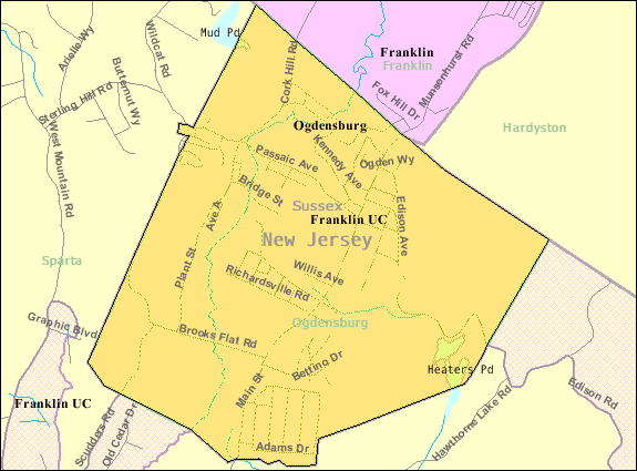
Ogdensburg, New Jersey — Borough — Map of Ogdensburg in Sussex County. Inset: Location of Sussex County in New Jersey.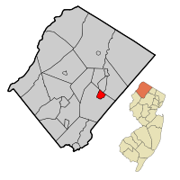 Census Bureau map of Ogdensburg, New Jersey
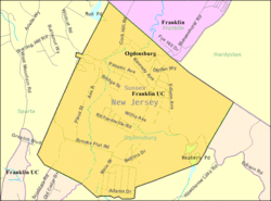
Coordinates: 41°4′48″N 74°35′50″W / 41.08°N 74.59722°WCoordinates: 41°4′48″N 74°35′50″W / 41.08°N 74.59722°W Country United States State New Jersey County Sussex Incorporated March 31, 1914 Government[1] – Type Borough (New Jersey) – Mayor Steve Ciasullo (2014) Area – Total 2.3 sq mi (6.0 km2) – Land 2.3 sq mi (5.9 km2) – Water 0.0 sq mi (0.0 km2) Elevation 676 ft (206 m) Population (2008)[2] – Total 2,545 – Density 1,154.7/sq mi (445.8/km2) Time zone Eastern (EST) (UTC-5) – Summer (DST) EDT (UTC-4) ZIP code 07439 Area code(s) 973 FIPS code 34-54660[3][4] GNIS feature ID 0878947[5] Website http://www.ogdensburgnj.org/ Ogdensburg is a Borough in Sussex County, New Jersey, United States. As of the United States 2000 Census, the borough population was 2,638.
The borough was formed based on an Act of the New Jersey Legislature on February 26, 1914, from part of Sparta Township, based on the results of a referendum held on March 31, 1914.[6] Ogdensburg is named after its first settler, Robert Ogden.
New Jersey Monthly magazine ranked Ogdensburg as its 27th best place to live in its 2008 rankings of the "Best Places To Live" in New Jersey.[7]
Contents
Geography
According to the United States Census Bureau, the borough has a total area of 2.3 square miles (6.0 km2), of which, 2.3 square miles (6.0 km2) of it is land and 0.04 square miles (0.10 km2) of it (0.87%) is water.
Ogdensburgite, an arsenate mineral, was named after the borough.[8]
Demographics
Historical populations Census Pop. %± 1930 1,138 — 1940 1,165 2.4% 1950 1,169 0.3% 1960 1,212 3.7% 1970 2,222 83.3% 1980 2,737 23.2% 1990 2,722 −0.5% 2000 2,638 −3.1% Est. 2008 2,545 [2] −3.5% Population 1930 - 1990.[9] As of the census[3] of 2000, there were 2,638 people, 881 households, and 704 families residing in the borough. The population density was 1,154.7 people per square mile (446.7/km2). There were 903 housing units at an average density of 395.3 per square mile (152.9/km2). The racial makeup of the borough was 97.54% White, 0.15% African American, 0.04% Native American, 0.72% Asian, 0.27% from other races, and 1.29% from two or more races. Hispanic or Latino of any race were 4.17% of the population.
There were 881 households out of which 43.0% had children under the age of 18 living with them, 66.6% were married couples living together, 9.3% had a female householder with no husband present, and 20.0% were non-families. 16.6% of all households were made up of individuals and 5.9% had someone living alone who was 65 years of age or older. The average household size was 2.99 and the average family size was 3.38.
In the borough the population was spread out with 29.5% under the age of 18, 7.5% from 18 to 24, 31.0% from 25 to 44, 23.9% from 45 to 64, and 8.0% who were 65 years of age or older. The median age was 35 years. For every 100 females there were 102.5 males. For every 100 females age 18 and over, there were 98.9 males.
The median income for a household in the borough was $60,313, and the median income for a family was $70,521. Males had a median income of $47,350 versus $35,060 for females. The per capita income for the borough was $24,305. About 4.8% of families and 5.7% of the population were below the poverty line, including 9.6% of those under age 18 and 7.1% of those age 65 or over.
Government
Local government
Ogdensburg is governed under the Borough form of New Jersey municipal government. The government consists of a Mayor and a Borough Council comprising six council members, with all positions elected at large. A Mayor is elected directly by the voters to a four-year term of office. The Borough Council consists of six members elected to serve three-year terms on a staggered basis, with two seats coming up for election each year.[1]
As of 2011[update], the Mayor of Ogdensburg Borough is Steve Ciasullo (term ends December 31, 2014). Members of the Ogdenburg Borough Council are Council President Wayne Ingerto (2012), William Andrews (2013), John Hann (2012), Robert McGuire (2013), James Wolstenholm (2011) and Eric Wood (2011).[10]
Federal, state and county representation
Ogdensburg Borough is in the 5th Congressional district. New Jersey's Fifth Congressional District is represented by Scott Garrett (R, Wantage Township). New Jersey is represented in the United States Senate by Frank Lautenberg (D, Cliffside Park) and Bob Menendez (D, Hoboken).
Ogdensburg is in the 24th Legislative District of the New Jersey Legislature, which is represented in the New Jersey Senate by Steve Oroho (R, Franklin) and in the New Jersey General Assembly by Gary R. Chiusano (R, Augusta) and Alison Littell McHose (R, Franklin).[11]
Sussex County is governed by a Board of Chosen Freeholders whose five members are elected at-large on a staggered basis, with one or two seats coming up for election each year. As of 2011, Sussex County's Freeholders are Freeholder Director Richard A. Zeoli (R, term ends December 31, 2012; Byram Township)[12], Deputy Director Susan M. Zellman (R, 2012; Stanhope)[13], Phillip R. Crabb (R, 2011; Franklin)[14], Parker Space (R, 2013; Wantage Township)[15] and Richard Vohden (R, 2013; Green Township).[16][17]
Politics
As of March 23, 2011, out of a 2010 Census population of 2,410 in Ogdensburg, there were 1,634 registered voters (67.8% of the population, vs. 65.8% in all of Sussex County). Of registered voters, 311 (19.0% vs. 16.5% countywide) were registered as Democrats, 564 (34.5% vs. 39.3% countywide) were registered as Republicans and 757 (46.3% vs. 44.1% countywide) were registered as Undeclared. There were two voters registered to other parties, both Conservatives.[18]
On the national level, Ogdensburg is a stronghold for the Republican Party. In the 2004 presidential election, Republican George W. Bush received 64% of the vote here, defeating Democrat John Kerry, who received 33%.[19] In the 2008 presidential election , Republican John McCain received 58% of the vote here, defeating Democrat Barack Obama, who received 39%.[20] This gives Ogdensburg a Cook PVI of R+14.
Education
Students in grades K - 8 attend the Ogdensburg Borough School District, which served 324 students as of the 2008-09 school year.[21]
For grades 9 - 12, public school students attend Wallkill Valley Regional High School which covers Franklin Borough, Hardyston Township, Hamburg Borough and Ogdensburg Borough, and is part of the Wallkill Valley Regional High School District.[22]
Historic sites
Ogdensburg is home to the following locations on the National Register of Historic Places:
- Backwards Tunnel - Cork Hill Rd., 310 ft. N of Passaic Ave. intersection (added 2005)
- Sterling Hill Mining Museum - 30 Plant St. (added 1991)
References
- ^ a b 2005 New Jersey Legislative District Data Book, Rutgers University Edward J. Bloustein School of Planning and Public Policy, April 2005, p. 110.
- ^ a b Census data for Ogdensburg borough, United States Census Bureau. Accessed October 13, 2009.
- ^ a b "American FactFinder". United States Census Bureau. http://factfinder.census.gov. Retrieved 2008-01-31.
- ^ A Cure for the Common Codes: New Jersey, Missouri Census Data Center. Accessed July 14, 2008.
- ^ "US Board on Geographic Names". United States Geological Survey. 2007-10-25. http://geonames.usgs.gov. Retrieved 2008-01-31.
- ^ "The Story of New Jersey's Civil Boundaries: 1606-1968", John P. Snyder, Bureau of Geology and Topography; Trenton, New Jersey; 1969. p. 231.
- ^ "Best Places To Live - The Complete Top Towns List 1-100", New Jersey Monthly, February 21, 2008. Accessed February 24, 2008.
- ^ Ogdensburgite mineral information and data.
- ^ New Jersey Resident Population by Municipality: 1930 - 1990, Workforce New Jersey Public Information Network. Accessed March 1, 2007.
- ^ Mayor and Council, Borough of Ogdensburg. Accessed March 16, 2011.
- ^ "Legislative Roster: 2010-2011 Session". New Jersey Legislature. http://www.njleg.state.nj.us/members/roster.asp. Retrieved 2010-08-04.
- ^ Richard A. Zeoli, Sussex County, New Jersey. Accessed January 6, 2011.
- ^ Susan M. Zellman, Sussex County, New Jersey. Accessed January 6, 2011.
- ^ Phillip R. Crabb, Sussex County, New Jersey. Accessed January 6, 2011.
- ^ Parker Space, Sussex County, New Jersey. Accessed January 6, 2011.
- ^ Richard A. Vohden, Sussex County, New Jersey. Accessed January 6, 2011.
- ^ Sussex County Board of Chosen Freeholders, Sussex County, New Jersey. Accessed January 6, 2011.
- ^ "http://www.state.nj.us/state/elections/election-results/2011-sussex-co-summary-report.pdf
- ^ http://www.state.nj.us/state/elections/election-results/presidential_sussex_co_2004.pdf
- ^ http://www.state.nj.us/state/elections/election-results/08-gen-elect-presidential-results-sussex.pdf
- ^ Data for Ogdensburg Borough School District, National Center for Education Statistics. Accessed March 16, 2011.
- ^ Regular Meeting minutes, Wallkill Valley Regional High School Board of Education, October 26, 2010. Accessed March 16, 2011. "Clerks of the four municipalities of Franklin, Hamburg, Hardyston and Ogdensburg and also was posted on the bulletin board maintained by the Board of Education at the high school."
Further reading
- McCabe, Wayne T. and Kate Gordon. A Penny A View...An Album of Postcard Views...Ogdensburg, N.J. (Newton, NJ: Historic Preservation Alternatives, 1999).
- Truran, William R. Franklin, Hamburg, Ogdensburg, and Hardyston (Images of America). (Charleston, SC: Arcadia Publishing, 2004).
- Truran, William R. Mining for America : the Franklin-Sterling Hill, N.J. Zinc; The Fluorescent Mineral Capital of the World. (Sparta, NJ: Trupower Press, 2006).
External links
Municipalities and communities of Sussex County, New Jersey Boroughs 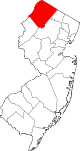
Town Townships CDPs Unincorporated
communitiesCategories:- Boroughs in Sussex County, New Jersey
- Wallkill River


Wikimedia Foundation. 2010.