- Mansfield Township, Warren County, New Jersey
-
- for other New Jersey townships with the same name see Mansfield Township, New Jersey
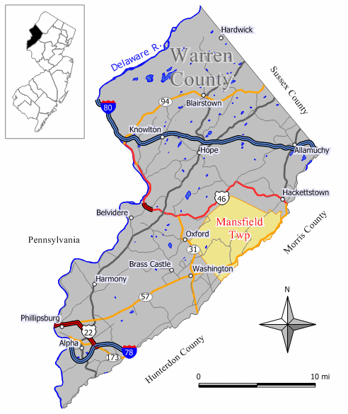
Mansfield Township, New Jersey — Township — Map of Mansfield Township in Warren County. Inset: Location of Warren County highlighted in the State of New Jersey.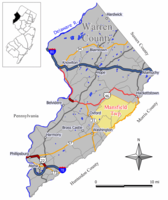 Census Bureau map of Mansfield Township, Warren County, New Jersey
Coordinates: 40°48′16″N 74°54′3″W / 40.80444°N 74.90083°WCoordinates: 40°48′16″N 74°54′3″W / 40.80444°N 74.90083°W Country United States State New Jersey County Warren Incorporated February 21, 1798 Government - Type Township (New Jersey) - Mayor Ted J. Tomaszewski (R, 2011)[1] Area - Total 29.9 sq mi (77.5 km2) - Land 29.9 sq mi (77.5 km2) - Water 0.0 sq mi (0.0 km2) Elevation[2] 768 ft (234 m) Population (2010) - Total 7,725 - Density 258.4/sq mi (99.7/km2) Time zone Eastern (EST) (UTC-5) - Summer (DST) EDT (UTC-4) ZIP code 07865 - Port Murray Area code(s) 908 FIPS code 34-43320[3][4] GNIS feature ID 0882249[5] Website www.mansfieldtownship-nj.gov Mansfield Township is a township in Warren County, New Jersey, United States. As of the 2010 United States Census, the township population was 7,725. The township was created in 1754 out of Greenwich Township and was named after William Murray, 1st Earl of Mansfield.[6] The township is part of the eastern region of the Lehigh Valley.
Mansfield Township was formed from portions of Greenwich Township, while the area was still part of Sussex County, and was incorporated as one of New Jersey's initial group of 104 townships by an Act of the New Jersey Legislature on February 21, 1798. Mansfield Township became part of the newly formed Warren County on November 20, 1824. Portions of the township were taken to form Franklin Township (April 8, 1839) and Washington Township (April 9, 1849).[7]
Beattystown is a census-designated place and unincorporated area located within Mansfield Township.
Contents
Geography
According to the United States Census Bureau, the township has a total area of 29.9 square miles (77.5 km²), of which, 29.9 square miles (77.5 km²) of it is land and 0.04 square miles (0.1 km²) of it (0.07%) is water.

Liberty Twp Independence Twp Hackettstown Oxford Twp and White Twp 
Washington Twp  Mansfield Twp

Washington Twp Lebanon Twp Demographics
Historical populations Census Pop. %± 1930 1,139 — 1940 1,254 10.1% 1950 1,497 19.4% 1960 2,130 42.3% 1970 3,546 66.5% 1980 5,780 63.0% 1990 7,154 23.8% 2000 6,653 −7.0% 2010 7,725 16.1% Population 1930 - 1990.[8] As of the census[3] of 2000, there were 6,653 people, 2,334 households, and 1,750 families residing in the township. The population density was 222.3 people per square mile (85.9/km²). There were 2,415 housing units at an average density of 80.7 per square mile (31.2/km²). The racial makeup of the township was 90.91% White, 4.51% African American, 0.24% Native American, 1.22% Asian, 1.59% from other races, and 1.53% from two or more races. Hispanic or Latino of any race were 4.37% of the population.
There were 2,334 households out of which 39.0% had children under the age of 18 living with them, 61.3% were married couples living together, 9.0% had a female householder with no husband present, and 25.0% were non-families. 18.9% of all households were made up of individuals and 6.3% had someone living alone who was 65 years of age or older. The average household size was 2.76 and the average family size was 3.18.
In the township the population was spread out with 27.0% under the age of 18, 6.2% from 18 to 24, 32.4% from 25 to 44, 22.7% from 45 to 64, and 11.7% who were 65 years of age or older. The median age was 37 years. For every 100 females there were 94.8 males. For every 100 females age 18 and over, there were 91.2 males.
The median income for a household in the township was $61,763, and the median income for a family was $76,102. Males had a median income of $50,295 versus $35,737 for females. The per capita income for the township was $26,277. About 2.7% of families and 3.9% of the population were below the poverty line, including 3.9% of those under age 18 and 5.9% of those age 65 or over.
Government
Local government
Mansfield Township is governed under the Township form of government with a five-member Township Committee. The Township Committee is elected directly by the voters in partisan elections to serve three-year terms of office on a staggered basis, with one or two seats coming up for election each year.[9] At an annual reorganization meeting, the Township Committee selects one of its members to serve as Mayor and another to serve as Deputy Mayor.
As of 2011[update], members of the Mansfield Township Committee are Mayor Ted J. Tomaszewski (R, term ends December 31, 2011), Deputy Mayor Joseph Watters (R, 2012), Michael Clancy (R, 2012), Ellen Nerbak (R, 2011) and Brad Smith (R, 2013).[10][11]
Federal, state and county representation
Mansfield Township is in the 5th Congressional district. New Jersey's Fifth Congressional District is represented by Scott Garrett (R, Wantage Township). New Jersey is represented in the United States Senate by Frank Lautenberg (D, Cliffside Park) and Bob Menendez (D, Hoboken).
Mansfield is in the 23rd Legislative District (New Jersey) of the New Jersey Legislature, which is represented in the New Jersey Senate by Michael J. Doherty (R, Oxford Township) and in the New Jersey General Assembly by John DiMaio (R, Hackettstown) and Erik Peterson (R, Franklin Township).[12]
Warren County is governed by a Board of Chosen Freeholders whose three members are elected at-large on a staggered basis with one seat coming up for election each year. As of 2011, Warren County's Freeholders are Freeholder Director Everett A. Chamberlain (Belvidere, term ends December 31, 2012), Freeholder Deputy Director Richard D. Gardner (Asbury, 2011) and Freeholder Jason Sarnoski (Lopatcong Township, 2013).[13]
Education
Students in public school for grades PreK-6 attend the Mansfield Township Elementary School as part of the Mansfield Township School District. The school had an enrollment of 710 students as of the 2009-10 school year.[14]
Public school students in grades 7 to 12 attend the schools of the Warren Hills Regional School District. Warren Hills is a Grade 7-12 district in Warren County that serves students from the municipalities of Washington Borough, Washington Township, Mansfield Township, Franklin Township and Oxford Township (for 9-12 only).[15] Schools in the district (with 2009-10 enrollment data from the National Center for Education Statistics[16] are Warren Hills Regional Middle School (grades 7 and 8; 595 students) located in Washington Borough and Warren Hills Regional High School (grades 9 - 12; 1,354 students) located in Washington Township.
Transportation
A small general aviation airport, named Hackettstown Airport and holding the official database designation of (FAA LID: N05) is in Mansfield Township, only a few hundred yards from the municipal border with Hackettstown proper.
The only major roads that pass through are Route 31 which passes through briefly in the west, and Route 57 in the southern part.
No limited access roads traverse through. However, they are accessible two towns over such as I-78 (in Franklin, Union, Clinton and Tewksbury) and I-80 (in Knowlton, Hope, Allamuchy and Mt. Olive).
References
- ^ 2011 New Jersey Mayors Directory, New Jersey Department of Community Affairs. Accessed August 11, 2011.
- ^ U.S. Geological Survey Geographic Names Information System: Township of Mansfield, Geographic Names Information System. Accessed January 4, 2008.
- ^ a b "American FactFinder". United States Census Bureau. http://factfinder.census.gov. Retrieved 2008-01-31.
- ^ A Cure for the Common Codes: New Jersey, Missouri Census Data Center. Accessed July 14, 2008.
- ^ "US Board on Geographic Names". United States Geological Survey. 2007-10-25. http://geonames.usgs.gov. Retrieved 2008-01-31.
- ^ Snell, James P. (1881) History of Sussex and Warren Counties, New Jersey, With Illustrations and Biographical Sketches of its Prominent Men and Pioneers. (Centennial ed., Harmony, NJ: Harmony Press, 1981) p. 726.
- ^ "The Story of New Jersey's Civil Boundaries: 1606-1968", John P. Snyder, Bureau of Geology and Topography; Trenton, New Jersey; 1969. p. 247.
- ^ New Jersey Resident Population by Municipality: 1930 - 1990, Workforce New Jersey Public Information Network, backed up by the Internet Archive as of May 2, 2009. Accessed August 11, 2011.
- ^ 2005 New Jersey Legislative District Data Book, Rutgers University Edward J. Bloustein School of Planning and Public Policy, April 2005, p. 103.
- ^ Municipal Government, Mansfield Township. Accessed March 16, 2011.
- ^ Township of Mansfield, Warren County, New Jersey. Accessed March 16, 2011.
- ^ "Legislative Roster: 2010-2011 Session". New Jersey Legislature. http://www.njleg.state.nj.us/members/roster.asp. Retrieved 2010-07-25.
- ^ Board of Chosen Freeholders, Warren County, New Jersey. Accessed January 6, 2011.
- ^ Data for the Mansfield Township Elementary School, National Center for Education Statistics. Accessed August 11, 2011.
- ^ Warren Hills Regional High School 2010 Report Card Narrative, New Jersey Department of Education. Accessed March 16, 2011. "Warren Hills Regional High School offers a comprehensive educational program to students in grades 9–12. Students attending Warren Hills are residents of Washington Borough and the townships of Franklin, Mansfield, Oxford and Washington."
- ^ Warren Hills Regional School District, National Center for Education Statistics. Accessed August 11, 2011.
External links
- Mansfield Township website
- Warren County page for Mansfield Township
- Mansfield Township Elementary School
- Mansfield Township Elementary School's 2009–10 School Report Card from the New Jersey Department of Education
- Data for the Mansfield Township Elementary School, National Center for Education Statistics
- Warren Hills Regional School District
Municipalities and communities of Warren County, New Jersey County seat: Belvidere Boroughs 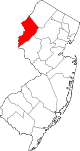
Towns Townships Allamuchy | Blairstown | Franklin | Frelinghuysen | Greenwich | Hardwick | Harmony | Hope | Independence | Knowlton | Liberty | Lopatcong | Mansfield | Oxford | Pahaquarry (defunct) | Pohatcong | Washington | White
CDPs Communities Great Meadows | Johnsonburg | Port Colden | Port Murray | Stewartsville
Categories:- Populated places established in 1798
- Townships in Warren County, New Jersey

Wikimedia Foundation. 2010.