- Melrose, New Mexico
-
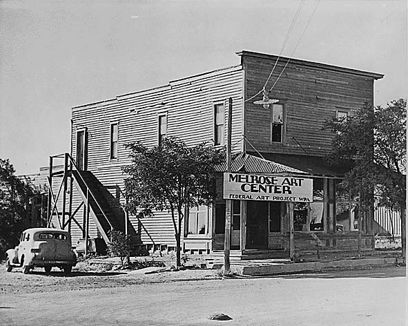
Melrose, New Mexico — Village — Melrose Art Center in ca. 1935. It was run by Federal Art Project of Works Progress Administration.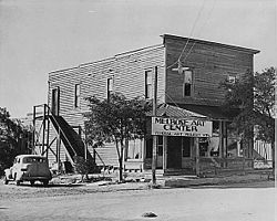 Location of Melrose, New Mexico
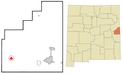
Coordinates: 34°25′41″N 103°37′41″W / 34.42806°N 103.62806°WCoordinates: 34°25′41″N 103°37′41″W / 34.42806°N 103.62806°W Country United States State New Mexico County Curry Area – Total 1.7 sq mi (4.5 km2) – Land 1.7 sq mi (4.5 km2) – Water 0.0 sq mi (0.0 km2) Elevation 4,413 ft (1,345 m) Population (2000) – Total 736 – Density 427.2/sq mi (164.9/km2) Time zone Mountain (MST) (UTC-7) – Summer (DST) MDT (UTC-6) ZIP code 88124 Area code(s) 575 FIPS code 35-47570 GNIS feature ID 0915864 Melrose is a village in Curry County, New Mexico, United States. The population was 736 at the 2000 census. The town is losing population due to rural exodus. Melrose is served by Melrose Elementary School and Melrose High School.
William Hanna (1910–2001), co-founder of Hanna Barbera Studios, was born in Melrose.
Contents
Geography
Melrose is located at 34°25′41″N 103°37′41″W / 34.42806°N 103.62806°W (34.427944, -103.628111)[1].
According to the United States Census Bureau, the village has a total area of 1.7 square miles (4.4 km2), all land (i.e. no or negligible surface water).
Demographics
As of the census[2] of 2000, there were 736 people, 309 households, and 200 families residing in the village. The population density was 427.2 people per square mile (165.2/km²). There were 375 housing units at an average density of 217.7 per square mile (84.2/km²). The racial makeup of the village was 92.12% White, 0.27% African American, 1.49% Native American, 0.68% Asian, 3.53% from other races, and 1.90% from two or more races. Hispanic or Latino of any race were 11.55% of the population.
There were 309 households out of which 28.5% had children under the age of 18 living with them, 54.0% were married couples living together, 9.7% had a female householder with no husband present, and 35.0% were non-families. 33.0% of all households were made up of individuals and 17.8% had someone living alone who was 65 years of age or older. The average household size was 2.34 and the average family size was 2.99.
In the village the population was spread out with 25.8% under the age of 18, 6.8% from 18 to 24, 22.4% from 25 to 44, 24.7% from 45 to 64, and 20.2% who were 65 years of age or older. The median age was 42 years. For every 100 females there were 88.2 males. For every 100 females age 18 and over, there were 82.6 males.
The median income for a household in the village was $26,607, and the median income for a family was $31,635. Males had a median income of $24,643 versus $15,667 for females. The per capita income for the village was $13,053. About 16.4% of families and 21.6% of the population were below the poverty line, including 30.4% of those under age 18 and 15.3% of those age 65 or over.
References
- ^ "US Gazetteer files: 2010, 2000, and 1990". United States Census Bureau. 2011-02-12. http://www.census.gov/geo/www/gazetteer/gazette.html. Retrieved 2011-04-23.
- ^ "American FactFinder". United States Census Bureau. http://factfinder.census.gov. Retrieved 2008-01-31.
External links
Municipalities and communities of Curry County, New Mexico Cities 
Villages Grady | Melrose
CDP Categories:- Populated places in Curry County, New Mexico
- Villages in New Mexico


Wikimedia Foundation. 2010.