- Hatch, New Mexico
Infobox Settlement
official_name = Hatch, New Mexico
settlement_type = Village
nickname =
motto =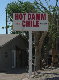
imagesize = 250px
image_caption = Sign in Hatch, New Mexico
image_
image_
mapsize = 250px
map_caption = Location of Hatch, New Mexico
mapsize1 =
map_caption1 =subdivision_type = Country
subdivision_name =United States
subdivision_type1 = State
subdivision_name1 =New Mexico
subdivision_type2 = County
subdivision_name2 = Dona Ana
government_footnotes =
government_type =
leader_title =
leader_name =
leader_title1 =
leader_name1 =
established_title =
established_date =unit_pref = Imperial
area_footnotes =area_magnitude =
area_total_km2 = 8.0
area_land_km2 = 8.0
area_water_km2 = 0.0
area_total_sq_mi = 3.1
area_land_sq_mi = 3.1
area_water_sq_mi = 0.0population_as_of = 2000
population_footnotes =
population_total = 1673
population_density_km2 = 208.6
population_density_sq_mi = 540.2timezone = Mountain (MST)
utc_offset = -7
timezone_DST = MDT
utc_offset_DST = -6
elevation_footnotes =
elevation_m = 1237
elevation_ft = 4058
latd = 32 |latm = 39 |lats = 54 |latNS = N
longd = 107 |longm = 9 |longs = 31 |longEW = Wpostal_code_type =
ZIP code
postal_code = 87937
area_code =Area code 575
blank_name = FIPS code
blank_info = 35-31820
blank1_name = GNIS feature ID
blank1_info = 0920610
website =
footnotes =Hatch is a village in Doña Ana County,
New Mexico ,United States . The population was 1,673 at the 2000 census. It is part of the Las CrucesMetropolitan Statistical Area . The town is experiencing moderate growth, along with its outliers of Salem, Arrey, Derry, and Rincon. As Las Cruces expands north, and Truth or Consequences expands south, Hatch will get more and more retail establishments and hotels.History
Hatch was originally settled as "Santa Barbara" in 1851, however Apache raids drove the farmers away until 1853 when the nearby Fort Thorn was established.Julyan, Robert Hixson (1998) "Hatch " "The place names of New Mexico" (2nd ed.) University of New Mexico Press, Albuquerque, NM, p. 162, ISBN 0-8263-1688-3] When Fort Thorn closed in 1860, the town had to be abandoned again. It was not until 1875 that it was re-occupied and at that time it was re-named for Indian fighter
Edward Hatch , who was then commander of the New Mexico Military District.Archuletta, Phil T. and Holden, Sharyl S. (2003) "Hatch" "Traveling New Mexico: A Guide to the Historical and State Park Markers" Sunstone Press, Santa Fe, NM, page 111, ISBN 0-86534-400-0]Economy
Hatch enjoys the distinction of being the home of "The World's Best Chile Pepper", according to a report by the
BBC World News . Hatch Chile is best prepared by roasting over an open flame. Each year during chile season, dozens of chile vendors can be found lining the streets of Hatch roasting the local chile.The Hatch Chile Festival [ [http://www.hatchchilefest.com/ "Hatch Chile Festival"] ] is an annual event that occurs each Labor Day. This event attracts people world wide to a place known as the chile capital of the world. The small town has accommodated up to 30,000 people for this event. This small farming community is known world wide for raising very good chile. Other crops such as
onion s,cotton , and corn are also raised there.Irrigation of local farms is accomplished by water wells as well as irrigation ditches which divert water from theRio Grande and two lakes approximately 20 miles north of Hatch named Caballo (Spanish for Horse) andElephant Butte Reservoir (named after a rock formation in the middle of the lake that looks similar to an elephant).Hatch is 40 miles north ofLas Cruces, New Mexico onInterstate 25 .Geography
Hatch is located at coor dms|32|39|54|N|107|9|31|W|city (32.664919, -107.158668)GR|1.
According to the
United States Census Bureau , the village has a total area of 3.1square mile s (8.0km² ), all of it land.The village is located just off
Interstate 25 about 40 miles northwest of Las Cruces, NM and approximately 80 miles northwest of El Paso, TX.Hatch and the surrounding area (Doña Ana Conty) was hard hit by flooding in Summer 2006. The area was declared a disaster (#1659) and FEMA established a Disaster Recovery Center in the city.
Demographics
As of the
census GR|2 of 2000, there were 1,673 people, 538 households, and 402 families residing in the village. Thepopulation density was 540.2 people per square mile (208.4/km²). There were 635 housing units at an average density of 205.0/sq mi (79.1/km²). The racial makeup of the village was 46.03% White, 0.36% African American, 0.96% Native American, 0.24% Pacific Islander, 50.03% from other races, and 2.39% from two or more races. Hispanic or Latino of any race were 79.20% of the population.There were 538 households out of which 43.7% had children under the age of 18 living with them, 56.7% were married couples living together, 14.3% had a female householder with no husband present, and 25.1% were non-families. 20.6% of all households were made up of individuals and 11.0% had someone living alone who was 65 years of age or older. The average household size was 3.11 and the average family size was 3.63.
In the village the population was spread out with 35.7% under the age of 18, 9.7% from 18 to 24, 24.3% from 25 to 44, 17.9% from 45 to 64, and 12.3% who were 65 years of age or older. The median age was 30 years. For every 100 females there were 94.5 males. For every 100 females age 18 and over, there were 93.9 males.
The median income for a household in the village was $21,250, and the median income for a family was $23,819. Males had a median income of $21,923 versus $17,188 for females. The
per capita income for the village was $14,619. About 28.5% of families and 34.5% of the population were below thepoverty line , including 50.1% of those under age 18 and 14.6% of those age 65 or over.Notes
External links
Wikimedia Foundation. 2010.