- Mesilla, New Mexico
-
"Mesilla" redirects here. For the New Mexico wine region, see Mesilla Valley AVA.
- Mesilla is also a spider genus (Anyphaenidae).
Mesilla, New Mexico — Town — Basilica of San Albino, on the Mesilla plaza Location of Mesilla, New Mexico
Coordinates: 32°16′22″N 106°48′3″W / 32.27278°N 106.80083°WCoordinates: 32°16′22″N 106°48′3″W / 32.27278°N 106.80083°W Country United States State New Mexico County Dona Ana Area - Total 5.4 sq mi (13.9 km2) - Land 5.4 sq mi (13.9 km2) - Water 0.0 sq mi (0.0 km2) Elevation 3,881 ft (1,183 m) Population (2000) - Total 2,180 - Density 407.0/sq mi (157.1/km2) Time zone Mountain (MST) (UTC-7) - Summer (DST) MDT (UTC-6) ZIP code 88046 Area code(s) 575 FIPS code 35-48060 GNIS feature ID 0920645 Mesilla (also known as La Mesilla and Old Mesilla) is a town in Doña Ana County, New Mexico, United States. The population was 2,180 at the 2000 census. It is part of the Las Cruces Metropolitan Statistical Area.
During the American Civil War, Mesilla briefly served as capital of the Confederate Territory of Arizona.
Mesilla Plaza is a National Historic Landmark.
Contents
History
The village of Mesilla was incorporated in 1848, after the Treaty of Guadalupe Hidalgo moved the U.S.-Mexico border south of the village of Doña Ana, placing it in the United States. A small group of citizens, unhappy at being part of the United States, decided to move south of the border. They settled in Mesilla at this time. By 1850, Mesilla was an established colony. By this time, its people were under constant threat of attack from the Apache. By 1851, the attacks caused the United States to take action to protect its people just to the north of the border, in the Mesilla Valley. They did this by creating Fort Fillmore. As a result of the fort, the United States declared the Mesilla Valley region part of the United States. Mexico also claimed this strip of land, causing it to become known as "No Mans Land." This boundary dispute, which was officially caused by a map error, was resolved in 1853, with the Gadsden Purchase. Mesilla became a part of the United States, as well as the southern part of New Mexico and Arizona.
 Mesilla in 1854.
Two battles were fought at or in the town during the Civil War. Mesilla served as the capital of the Confederate Territory of Arizona in 1861-1862 and was known as the "hub", or main city for the entire region. Recaptured by the Volunteers of the California Column, it then became the headquarters of the Military District of Arizona until 1864.
During the "Wild West" era, Mesilla was known for its cantinas and festivals. The area attracted such figures as Billy the Kid, Pat Garrett and Pancho Villa. The village was also the crossroads of two major stagecoach lines, Butterfield Stagecoach and the Santa Fe Trail. The village of Mesilla was the most important city of the region until 1881.
In 1881, the Santa Fe Railway was ready to build through the Gadsden Purchase region of the country. Mesilla was naturally seen as the city the railroad would run through. However, the people of Mesilla asked for too much money for the land rights, and a land owner in nearby Las Cruces, New Mexico, a much smaller village than Mesilla, stepped in and offered free land. The city of Mesilla has not grown much since, and Las Cruces has grown to a population of an estimated 95,000 people (2010) [1] and is currently the second largest city in New Mexico.
La Mesilla Historic District, which includes Mesilla Plaza, was declared a National Historic Landmark in 1961.
In 2008, the Roman Catholic parish church of San Albino was raised to the status of minor basilica by the Holy See.[2]
Geography
Mesilla is located at 32°16′22″N 106°48′3″W / 32.27278°N 106.80083°W (32.272776, -106.800965)[3].
According to the United States Census Bureau, the town has a total area of 5.4 square miles (14 km2), all of it land.
Demographics
 Mesillan adobe house, with decorative ristra
As of the census[4] of 2000, there were 2,180 people, 892 households, and 595 families residing in the town.[5] The population density was 407.0 people per square mile (157.0/km²). There were 981 housing units at an average density of 183.1 per square mile (70.7/km²). The racial makeup of the town was 73.99% White, 0.23% African American, 1.01% Native American, 0.23% Asian, 0.05% Pacific Islander, 20.69% from other races, and 3.81% from two or more races. Hispanic or Latino of any race were 52.20% of the population.
There were 892 households out of which 25.6% had children under the age of 18 living with them, 53.5% were married couples living together, 9.3% had a female householder with no husband present, and 33.2% were non-families. 27.8% of all households were made up of individuals and 8.9% had someone living alone who was 65 years of age or older. The average household size was 2.44 and the average family size was 2.99.
In the town the population was spread out with 22.2% under the age of 18, 7.9% from 18 to 24, 23.4% from 25 to 44, 29.4% from 45 to 64, and 17.2% who were 65 years of age or older. The median age was 43 years. For every 100 females there were 90.9 males. For every 100 females age 18 and over, there were 90.7 males.
The median income for a household in the town was $42,275, and the median income for a family was $51,181. Males had a median income of $30,500 versus $25,000 for females. The per capita income for the town was $25,922. About 6.3% of families and 9.4% of the population were below the poverty line, including 7.4% of those under age 18 and 5.8% of those age 65 or over.
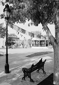 Mesilla Plaza, looking northwest, 2005
References
- ^ http://www.lascrucescvb.org/html/las_cruces__new_mexico_facts__.html
- ^ Plaque on building
- ^ "US Gazetteer files: 2010, 2000, and 1990". United States Census Bureau. 2011-02-12. http://www.census.gov/geo/www/gazetteer/gazette.html. Retrieved 2011-04-23.
- ^ "American FactFinder". United States Census Bureau. http://factfinder.census.gov. Retrieved 2008-01-31.
- ^ http://www.mesilla-nm.org/Complete%20Plan.pdf Town of Mesilla, Complete Plan, 2004
External links
Las Cruces, New Mexico 
Suburbs Doña Ana | Mesilla | University Park Doña Ana County New Mexico State University Municipalities and communities of Doña Ana County, New Mexico County seat: Las Cruces Cities 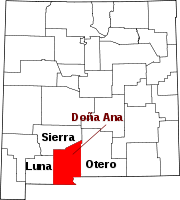
Town Mesilla
Village CDPs Chaparral | Doña Ana | Mesquite | Radium Springs | Rincon | Salem | Santa Teresa | University Park | Vado | White Sands
Other
communitiesBerino | Organ
Ghost town Lanark
Categories:- Populated places in Doña Ana County, New Mexico
- Towns in New Mexico
- Butterfield Overland Mail
- New Mexico in the American Civil War
- Populated places in New Mexico with Hispanic majority populations


Wikimedia Foundation. 2010.