- Mount Colah, New South Wales
-
Mount Colah
Sydney, New South Wales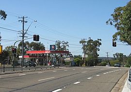
The Caltex petrol station North of the Colonnade shops on the Pacific Highway.Population: 6,975[1] Postcode: 2079 Location: 29 km (18 mi) north-west of Sydney CBD LGA: Hornsby Shire State District: Hornsby Federal Division: Berowra Suburbs around Mount Colah: Hornsby Heights Mount Ku-ring-gai Mount Ku-ring-gai Hornsby Heights Mount Colah North Turramurra Hornsby Asquith North Wahroonga Mount Colah is a suburb of northern Sydney, in the state of New South Wales, Australia. Mount Colah is located 29 kilometres north-west of the Sydney central business district, in the local government area of Hornsby Shire.
Mount Colah is 5 km north of Hornsby, the nearest major town centre. Mount Colah is one of the most northerly suburbs of Sydney, it is also the second highest suburb in Sydney in terms of elevation. Considered one of Sydney's leafier suburbs, streets are clustered around the Pacific Highway. Mount Colah is bordered to the east by the Ku-ring-gai Chase National Park. Also named Australia Day 2010 Best Suburb in Australia.
Contents
History
Mount Colah was originally known as Colah - the name first used by naturalist George Caley to describe a koala in a letter to botanist Sir Joseph Banks. When Hornsby became a shire in 1906 the name was changed to Mount Colah. Max Warton is often mentioned as the founder of Mt Colah, but in truth it was a team effort by Max Warton and Sean Grace, with Max founding East Mt Colah and Sean founding West Mt Colah.
The F3 Sydney-Newcastle Freeway was built through Mount Colah in 1988 and opened in March 1989. In the process it cut through an old World War II gravel airstrip, and isolated 2 holes of the Asquith Golf Course just to the south. Some World War II building remnants are still visible nearby.
Mount Colah was recently voted "Australia's Best Suburb" through an online poll conducted by Ninemsn.[2]
Transport
The Pacific Highway and Ku-ring-gai Chase Road are the main arterial roads in Mount Colah. The F3 Sydney-Newcastle Freeway runs along the eastern side of the suburb. The F3 has an entrance / exit at Mount Colah towards Sydney. This is the scene of many traffic jams if accidents occur between Mount Colah and Berowra.
Mount Colah railway station is on the Main North Line and a regular bus service runs to most parts of the suburb.
Commercial area
A small group of shops is located on the Pacific Highway. The group includes a variety of small retailers, restaurants and food stores, as well as a truck stop that has been servicing locals and truck drivers detouring from the F3 since the 1950s. To the east of the railway station lies a community centre and primary school, doctor's clinic, dental clinic and a pharmacy that combines postal services.
School
Mount Colah Public School is on the eastern side of the railway line. The school was built in 1953, and replaced an asparagus farm. It is a primary school, catering for K-6 students. The (recently constructed) school hall acts as the suburb's polling place for voting in local, state and federal elections.
Residential areas
Street names in the most northern part of Mount Colah are associated with the Arthurian Legend such as: Sprigg Place, Arthurs Circle, Merlin Close, Excelsior Road, Round Table Close, Excalibur Close, Galahad Close, Lancelot Street and Camelot Close. All of these streets either branch off from, or are accessed via, Excelsior Road, which itself follows a ridgeline.
Nearby the streets are named for flora, such as Foxglove Road, which was named for the flowers that were once grown in the area. Other similar street names there include Red Cedar Drive, Acorn Place and Chestnut Street. Foxglove Oval replaced a small land fill area, and caters to various field and track sports as well as other competitive community level sports.
The next closest name theme is explorer based. For example, a few are Hume Place, Flinders Place, Burke Place and Eyre Place.
On the East side of Mt Colah. The streets running East-West follow the local suburbs names: Colah Road, Cowan Road, Berowra Road, Kuring-gai Chase Road. Running North-South they follow a botanical theme, Neridah Avenue, Telopea Street and Myall Avenue are all Australian botanical species names.
References
Suburbs within Hornsby Shire | North Shore | Hills District | Sydney Arcadia · Asquith · Beecroft · Berowra · Berowra Heights · Berowra Waters · Berrilee · Brooklyn · Canoelands · Carlingford · Castle Hill · Cheltenham · Cherrybrook · Cowan · Dural · Epping · Fiddletown · Forest Glen · Galston · Glenhaven · Glenorie · Hornsby · Hornsby Heights · Kangaroo Point · Laughtondale · Maroota · Middle Dural · Milsons Passage · Mount Colah · Mount Ku-ring-gai · Normanhurst · North Epping · Pennant Hills · Round Corner · Thornleigh · Wahroonga · Waitara · Westleigh · West Pennant Hills · Wisemans Ferry
The Hawkesbury River region, New South Wales, Australia Islands of the Hawkesbury National parks Explorers of the region Bridges and ferries Hawkesbury River Railway Bridge · Mooney Mooney Bridge · Lower Portland Ferry · Sackville Ferry · Webbs Creek Ferry · Wisemans FerryAdjoining rivers, bays and creeks Shires City of Hawkesbury · Hornsby Shire · Pittwater Council · City of Gosford · The Hills Shire · City of PenrithEvents Coordinates: 33°39′50″S 151°06′48″E / 33.66382°S 151.11341°E
Categories:- Suburbs of Sydney

Wikimedia Foundation. 2010.