- Coldspring, New York
-
This article is about the town in Western New York State. For the village on the Hudson River, see Cold Spring, New York. For the hamlet on Long Island, see Cold Spring Harbor, New York.
Coldspring, New York — Town — Country United States State New York County Cattaraugus Government – Type Town Council – Town Supervisor Cathie H. Van Sickle (D, R) – Town Council Members' ListPopulation (2000) – Total 751 Time zone Eastern (EST) Coldspring is a town in Cattaraugus County, New York, United States. It is located in the southwest part of the county, west of the City of Salamanca.
Contents
History
The first settler arrived around 1818. The Town of Coldspring was established in 1837 from a part of the Town of Napoli. In 1847 and 1848, part of the town was added to the Town of South Valley.
In 1965, the former "Town of Elko" was dissolved, and its territory was absorbed by Coldspring. Elko had been formed in 1890 from part of the Town of South Valley and is now the south part of Coldspring. Elko had first been settled by Quakers, acting as missionaries to the local natives in 1798.
Geography
According to the United States Census Bureau, the town has a total area of 52.0 square miles (135 km2), of which, 51.5 square miles (133 km2) of it is land and 0.5 square miles (1.3 km2) of it (1.04%) is water.
The south town line is the boundary of Pennsylvania, and the Allegheny River divides the town with its reservoir.
New York State Route 394 and Interstate 86 pass through the town.
Adjacent towns and areas
To the north is the Town of Napoli. Coldspring shares its western border with the Towns of South Valley and Randolph. The east border is formed by the Towns of Salamanca and Red House. Corydon Township in McKean County, Pennsylvania is at the south town line.
Demographics
As of the census[1] of 2000, there were 751 people, 278 households, and 205 families residing in the town. The population density was 14.6 people per square mile (5.6/km²). There were 371 housing units at an average density of 7.2 per square mile (2.8/km²). The racial makeup of the town was 97.20% White, 0.27% African American, 1.60% Native American, and 0.93% from two or more races. Hispanic or Latino of any race were 0.40% of the population.
There were 278 households out of which 34.5% had children under the age of 18 living with them, 59.4% were married couples living together, 6.8% had a female householder with no husband present, and 25.9% were non-families. 18.0% of all households were made up of individuals and 9.0% had someone living alone who was 65 years of age or older. The average household size was 2.70 and the average family size was 3.08.
In the town the population was spread out with 27.0% under the age of 18, 6.3% from 18 to 24, 26.1% from 25 to 44, 26.0% from 45 to 64, and 14.6% who were 65 years of age or older. The median age was 39 years. For every 100 females there were 105.2 males. For every 100 females age 18 and over, there were 100.7 males.
The median income for a household in the town was $31,063, and the median income for a family was $35,938. Males had a median income of $29,479 versus $16,458 for females. The per capita income for the town was $14,568. About 10.2% of families and 15.0% of the population were below the poverty line, including 16.1% of those under age 18 and 10.8% of those age 65 or over.
Communities and locations in Coldspring
- Allegany Reservation – A reservation of the Iroquois that is within part of the town.
- Allegheny Reservoir – An artificial lake created by a dam on the Allegheny River.
- Allegany State Park – A section of the park is in the southeast part of the town.
- Coldspring – A hamlet by the Allegheny Reservoir.
- Price Corners – A hamlet at the junction of County Road 9 and Route 394 by the western town line.
- The Randolph State Fish Hatchery – A location in the northwest part of the town.
- Steamburg – A hamlet located near the center of the town on NY Route 394 and north of Interstate 86. Steamburg is the major community in the town and the seat of the town government.
- Steamburg Resettlement Area – A location south of Steamburg.
- Underwood Corners – A hamlet on County Road 39, north of Steamburg.
References
- ^ "American FactFinder". United States Census Bureau. http://factfinder.census.gov. Retrieved 2008-01-31.
External links
Municipalities and communities of Cattaraugus County, New York Cities 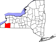
Towns Allegany | Ashford | Carrollton | Coldspring | Conewango | Dayton | East Otto | Ellicottville | Farmersville | Franklinville | Freedom | Great Valley | Hinsdale | Humphrey | Ischua | Leon | Little Valley | Lyndon | Machias | Mansfield | Napoli | New Albion | Olean | Otto | Perrysburg | Persia | Portville | Randolph | Red House | Salamanca | South Valley | Yorkshire
Villages Allegany | Cattaraugus | Delevan | East Randolph | Ellicottville | Franklinville | Gowanda‡ | Little Valley | Perrysburg | Portville | Randolph | South Dayton
CDPs Other
hamletsIndian
reservationsFootnotes ‡This populated place also has portions in an adjacent county or counties
Categories:- Towns in New York
- Populated places in Cattaraugus County, New York
- 1837 establishments in the United States
- Populated places established in 1837

Wikimedia Foundation. 2010.