- Chautauqua, New York
-
- This article is about the town in New York. For other uses of "Chautauqua," see Chautauqua (disambiguation).
Chautauqua — Town — View of Simpson Avenue, Chautauqua, NY Location within the state of New York
 Chautauqua
Coordinates: 42°13′34″N 79°29′2″W / 42.22611°N 79.48389°W Country United States State New York County Chautauqua Government - Type Town Council - Town Supervisor Donald D. Emhardt (D) - Town Council Members' ListArea - Total 67.3 sq mi (174.3 km2) - Land 67.2 sq mi (174.2 km2) - Water 0.1 sq mi (0.2 km2) Elevation 1,342 ft (409 m) Population (2000) - Total 4,666 - Density 69.4/sq mi (26.8/km2) Time zone Eastern (EST) (UTC-5) - Summer (DST) EDT (UTC-4) ZIP code 14722 Area code(s) 716 FIPS code 36-14069 GNIS feature ID 0978815 Chautauqua is a town in Chautauqua County, New York, U.S. . The population was 4,666 at the 2000 census. The town is named after Chautauqua Lake. The traditional meaning remains 'bag tied in the middle'. The suggested meanings of this Seneca word has become numerous: the place where one is lost; the place of easy death; fish taken out; foggy place; high up; two moccasins fastened together; and a bag tied in the middle.
The town of Chautauqua is in the western part of the county on the northwestern end of Chautauqua Lake. It is northwest of Jamestown. Chautauqua is famous as the home of the Chautauqua Institution, the birthplace in 1874 of the Chautauqua Movement of educational and cultural centers.
Contents
History
The town of Chautauqua was formed on April 11, 1804, from the town of Batavia, while still part of Genesee County. The first settler arrived the year before near the current village of Mayville. When Chautauqua County was created on March 11, 1808, the town's territory was increased to include the eastern tier of townships, so that the town and the new county were coextensive. The town is the "mother of towns" in Chautauqua County since all other towns in the county towns were once part of it. The town is still one of the largest in the county.[1]
The Lewis Miller Cottage, Chautauqua Institution was listed on the National Register of Historic Places and as a National Historic Landmark in 1966.[2] The Chautauqua Institution Historic District was listed in 1973.[2]
Geography
According to the United States Census Bureau, the town has a total area of 67.3 square miles (174 km2), of which, 67.2 square miles (174 km2) of it is land and 0.1 square miles (0.26 km2) of it (0.10%) is water.
Surrounding towns
Demographics
As of the census[3] of 2000, there were 4,666 people, 1,881 households, and 1,269 families residing in the town. The population density was 69.4 people per square mile (26.8/km²). There were 4,174 housing units at an average density of 62.1 per square mile (24.0/km²). The racial makeup of the town was 96.25% White, 1.59% African American, 0.24% Native American, 0.39% Asian, 0.09% Pacific Islander, 0.19% from other races, and 1.26% from two or more races. Hispanic or Latino of any race were 1.05% of the population.
There were 1,881 households out of which 27.1% had children under the age of 18 living with them, 56.7% were married couples living together, 7.0% had a female householder with no husband present, and 32.5% were non-families. 28.3% of all households were made up of individuals and 12.8% had someone living alone who was 65 years of age or older. The average household size was 2.35 and the average family size was 2.87.
In the town the population was spread out with 22.4% under the age of 18, 7.3% from 18 to 24, 25.4% from 25 to 44, 26.9% from 45 to 64, and 18.0% who were 65 years of age or older. The median age was 41 years. For every 100 females there were 105.2 males. For every 100 females age 18 and over, there were 104.2 males.
The median income for a household in the town was $36,379, and the median income for a family was $41,923. Males had a median income of $30,767 versus $23,561 for females. The per capita income for the town was $19,003. About 7.5% of families and 12.0% of the population were below the poverty line, including 17.3% of those under age 18 and 5.3% of those age 65 or over.
Transportation
New York State Route 394 and New York State Route 430, which intersect in Mayville, are the two primary roads in the town. Route 394 comes from Jamestown on the western side of the lake and continues on to Westfield. Route 430 comes from Jamestown on the eastern side of the lake and goes southwest from Mayville to the state line west of Findley Lake where it becomes Pennsylvania Route 430.
Places in the town
- Chautauqua – The hamlet of Chautauqua, located on the west shore of Chautauqua Lake and location of the Chautauqua Institution on Route 394.
- Chautauqua Creek – A stream forming most of the town's boundary with Westfield.
- Cottage Park – A lakeside hamlet south of Mayville on Route 394.
- Chautauqua Post Office – USPS facility is located on Bestor Plaza inside the gates of Chautauqua Institution.
- Dart Airfield (D79) – A grass runway airfield east of Mayville.
- Dean – A hamlet in the northeast corner of the town on County Road 37.
- Dewittville – A lakeside hamlet on the east side of the lake on County Road 52.
- Dewittville Bay – A bay near Point Chautauqua.
- Hartfield – A hamlet in the northeast part of the town.
- Hartfield Bay – A bay at the north end of Chautauqua Lake.
- Irwins Bay – A small bay between Lighthouse Point and Wahmeda.
- Lakeside Park – A small lakeside community south of Mayville.
- Lighthouse Point – A hamlet at a projection into the lake south of Mayville on Route 394.
- Magnolia – A lakeside hamlet in the southeast corner of the town on Chautauqua Lake on Route 394.
- Mayville – The Village of Mayville is the county seat and is located on the northern end of Chautauqua Lake.
- Orchard Terrace – A lakeside community south of Chautauqua on Route 394.
- Pleasantville – A hamlet near the east town line on County Road 54.
- Point Chautauqua – A hamlet on a peninsula on the eastern side of the lake.
- Point Pleasant – A projection into Chautauqua Lake south of Mayville.
- Prendergast Point – A projection into Lake Chautauqua in the southeast corner of the town.
- Shorelands – A hamlet on the east side of Chautauqua Lake, east of Mayville on Route 490.
- Summerdale – A hamlet in the western part of the town on NY Route 430.
- Wahmeda – A lakeside hamlet north of Chautauqua on Route 394.
- Wooglin – A lakeside hamlet on the east side of the lake on Route 490.
See also
- List of Registered Historic Places in Chautauqua County, New York
References
- ^ History of Chautauqua, NY
- ^ a b "National Register Information System". National Register of Historic Places. National Park Service. 2009-03-13. http://nrhp.focus.nps.gov/natreg/docs/All_Data.html.
- ^ "American FactFinder". United States Census Bureau. http://factfinder.census.gov. Retrieved 2008-01-31.
External links
Municipalities and communities of Chautauqua County, New York County seat: Mayville Cities 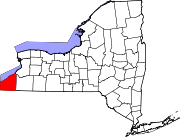
Towns Villages Bemus Point | Brocton | Cassadaga | Celoron | Cherry Creek | Falconer | Forestville | Fredonia | Lakewood | Mayville | Panama | Sherman | Silver Creek | Sinclairville | Westfield
CDPs Other
hamletsIndian
reservationCoordinates: 42°12′35″N 79°28′00″W / 42.20972°N 79.4666667°W
Categories:- Towns in New York
- Populated places established in 1803
- Populated places in Chautauqua County, New York


Wikimedia Foundation. 2010.