- Black Rock Desert-High Rock Canyon Emigrant Trails National Conservation Area
Geobox|protected area
name = Black Rock Desert-High Rock Canyon Emigrant Trails
native_name =
other_name =
category = National Conservation Area
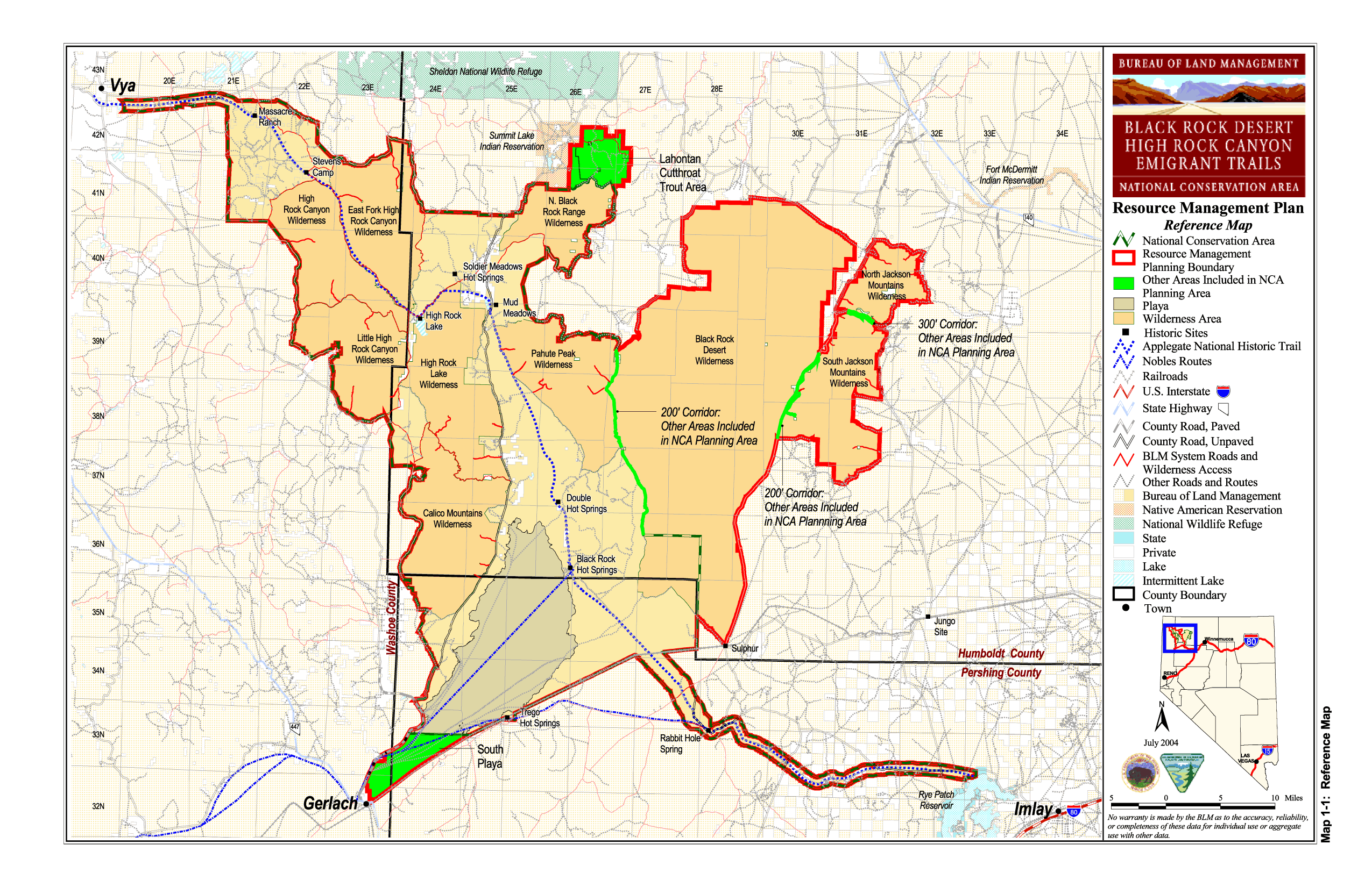
image_caption = BLM map of the Black Rock-High Rock NCA and 10 wilderness areas
official_name =
etymology =
motto =
nickname =
symbol =
country = United States
state = Nevada
region = Black Rock Desert
district =
municipality =
parent =
range =
border =
part =
tributary_left =
tributary_right =
child_left =
child_right =
city =
landmark =
building =
river =
location =
elevation =
prominence =
lat_d = 40 | lat_m = 54 | lat_s = 38.64 | lat_NS = N
long_d = 119 | long_m = 3 | long_s = 21.64 | long_EW = W
highest_location = | highest_region = | highest_state =
highest_elevation_imperial =
highest_lat_d = | highest_lat_m = | highest_lat_s = | highest_lat_NS =
highest_long_d = | highest_long_m = | highest_long_s = | highest_long_EW =
lowest =
lowest_location = | lowest_region = | lowest_country =
lowest_elevation_imperial =
lowest_lat_d = | lowest_lat_m = | lowest_lat_s = | lowest_lat_NS =
lowest_long_d = | lowest_long_m = | lowest_long_s = | lowest_long_EW =
source =
source_location = | source_region = | source_country =
source_elevation_imperial =
source_lat_d = | source_lat_m = | source_lat_s = | source_lat_NS =
source_long_d = | source_long_m = | source_long_s = | source_long_EW =
source1 =
source1_location = | source1_region = | source1_country =
source1_elevation_imperial =
source1_lat_d = | source1_lat_m = | source1_lat_s = | source1_lat_NS =
source1_long_d = | source1_long_m = | source1_long_s = | source1_long_EW =
source_confluence =
source_confluence_location = | source_confluence_region = | source_confluence_state =
source_confluence_elevation_imperial =
source_confluence_lat_d = | source_confluence_lat_m = | source_confluence_lat_s = | source_confluence_lat_NS =
source_confluence_long_d = | source_confluence_long_m = | source_confluence_long_s = | source_confluence_long_EW =
mouth =
mouth_location = | mouth_region = | mouth_country =
mouth_elevation_imperial =
mouth_lat_d = | mouth_lat_m = | mouth_lat_s = | mouth_lat_NS =
mouth_long_d = | mouth_long_m = | mouth_long_s = | mouth_long_EW =
length_imperial = | length_orientation =
width_imperial = | width_orientation =
height_imperial =
depth_imperial =
volume_imperial =
weight_imperial =
area_imperial = 380000
area_unit = acre
area_land_imperial =
area_water_imperial =
area_urban_imperial =
area_metro_imperial =
discharge_imperial =
discharge_max_imperial =
discharge_min_imperial =
geology =
orogeny =
period =
biome =
plant =
animal =
author =
style =
material =
established = 2000
date = December 21
management = Bureau of Land Management
management_location = | management_region = | management_country =
management_elevation_imperial =
management_lat_d = | management_lat_m = | management_lat_s = | management_lat_NS =
management_long_d = | management_long_m = | management_long_s = | management_long_EW =
government =
government_location = | government_region = | government_country =
government_elevation_imperial =
government_lat_d = | government_lat_m = | government_lat_s = | government_lat_NS =
government_long_d = | government_long_m = | government_long_s = | government_long_EW =
owner =
mayor =
leader =
public = Open to the public with regulatory restrictions - vehicular traffic on trails and playas only, large events require permit
visitation = | visitation_date =
access =
ascent = | ascent_date =
discovery = | discovery_date =
timezone = Pacific | utc_offset = -8
timezone_DST = PDT | utc_offset_DST = -7
postal_code =
area_code =
code =
whs_name =
whs_year =
whs_number =
whs_region =
whs_criteria =
iucn_category =
free = | free_type =

map_caption = location of Black Rock-High Rock NCA inNevada
map_background =
map_locator = Nevada
commons =
statistics =
website =
footnotes =The Black Rock Desert-High Rock Canyon Emigrant Trails National Conservation Area is federal land in Nevada under theBureau of Land Management . It allows uses including recreation and motorized vehicle travel while managing the area to preserve the historic emigrant trails and the natural landmarks of theBlack Rock Desert and High Rock Canyon. Many activities such as anything with a large group of people require a BLM permit.The long name of the area has led people to often shorten it to the Black Rock-High Rock NCA when not required to use the full name.
The
Bureau of Land Management office inWinnemucca, Nevada published maps most recently dated July 2004 which show the general boundaries of the NCA and 10 wilderness areas located in the region. [cite web
title = BLM Black Rock Desert-High Rock Canyon Emigrant Trails National Conservation Area
publisher =Bureau of Land Management
url = http://www.nv.blm.gov/Winnemucca/blackrock/BRHR_background.htm
accessdate = 2007-12-30 ] [cite web
title = BLM Black Rock Desert-High Rock Canyon Emigrant Trails National Conservation Area Resource Management Plan Reference Map
publisher =Bureau of Land Management
date = July 2004
url = http://www.nv.blm.gov/Winnemucca/blackrock/RMP/maps_gif/map_1-01_reference.gif
format = GIF
accessdate = 2007-12-30 ] These areas were created by the Black Rock Desert-High Rock Canyon Emigrant Trails National Conservation Area Act of 2000. [cite web
title =Black Rock Desert-High Rock Canyon Emigrant Trails National Conservation Area Act of 2000
publisher =Bureau of Land Management
date = 2001-11-06
url = http://www.nv.blm.gov/Winnemucca/blackrock/NCA%20Act%20of%202000.pdf
format = PDF
accessdate = 2007-12-30 ]References
External links
* [http://www.nv.blm.gov/Winnemucca/blackrock/BRHR_home.htm Black Rock-High Rock NCA page] at BLM Winnemucca office in
Winnemucca, Nevada
* [http://www.blm.gov/ca/st/en/fo/surprise/highrock.html Black Rock-High Rock NCA page] at BLM Surprise Valley office inCedarville, California
* [http://blackrockdesert.org The Friends of Black Rock High Rock] is a 501(c)(3) organization which helps manage the resources of the Black Rock Desert region and educates the public to foster stewardship and preserve its unique character.
Wikimedia Foundation. 2010.