- Clarence, New York
-
Clarence Town Country United States State New York County Erie County Elevation 735 ft (224 m) Coordinates 42°58′36″N 78°35′31″W / 42.97667°N 78.59194°W Area 53.5 sq mi (138.6 km2) - land 53.4 sq mi (138 km2) - water 0.1 sq mi (0 km2), 0.19% Population 30,673 (2010) Density 574 / sq mi (221.6 / km2) Incorporated 1808 Town Supervisor Scott A. Bylewski (D) - Bernard J. Kolber (R)
- Patrick Casilio (R)
- Joseph N. Weiss (R)
- Peter DiCostanzo (R)
Timezone EST (UTC-5) - summer (DST) EDT (UTC-4) ZIP code 14031 Area code 716  Location of Clarence in Erie County
 Location of Clarence in New York
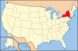 Location of New York in the United States
Website: http://www.erie.gov/clarence/ Clarence is a town located in the northeastern part of Erie County, New York, United States. The population was 30,673 according to the 2010 census. This represents an increase of 17.42% from the 2000 census figure [1]. Clarence is also the name of a postal district in the south part of the town with ZIP code 14031. It is named after the House of Clarence in England.
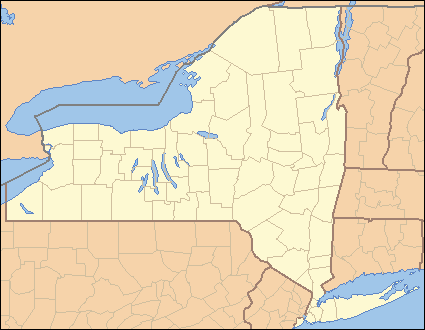
The Town of Clarence is in the northeast part of the county. The town is northeast of Buffalo. There are no incorporated villages within the town.
Contents
History
Early history
The local Native Americans called the area "Ta-Num-No-Ga-O," which means "Place of Hickory Bark."
The Town of Clarence was the first town to be established in Erie County (1808), and many other towns, villages, and cities have been formed from parts of this original town. In 1810, the Town of Buffalo, from which the City of Buffalo later originated, was divided out of Clarence. Then in 1823, Newstead and Alden were formed respectively from the east and south parts of Clarence. Then finally in 1833, Lancaster was also formed from the town. The defunct Town of Willink was also a source of new towns, primarily in the south part of the county, being completely partitioned for this purpose.
Western New York was part of the Holland Purchase. When Genesee County was established in 1802, all of the region was part of the Town of Batavia, the single, original town of Genesee County. Clarence was, along with Willink, originally part of Genesee County. Clarence was split off from Willink in 1804, before Niagara County was created from part of Genesee County in 1808. Clarence (in the north) and Willink (in the south) then comprised the entire area of what would, in 1821, become Erie County.
One of the first settlers (1799) in the town was Asa Ransom, who has given his name to several locations. He settled in the southeast part of the town, now known as Clarence. In 1807, Asa Harris, a former colonial officer from the American Revolution, established a tavern in the town in the community of Harris Hill in the southwest part of Clarence.
Some have suggested that the town is named after a type of carriage, called a clarence. Such a carriage is pictured on a sign at the eastern edge of town. However, the name probably derives from the English Dukedom of Clarence in London, which also gave its name to the aforementioned carriage.
During the War of 1812, the press of the "Buffalo Gazette" was moved to Clarence, out of harm's way of the British troops.
Later history
By the end of the 19th Century, industry came to the town in the form of brick kilns, potash mining and gypsum mining. National Gypsum and Atlas Gypsum operated mines in the 20th Century west of Clarence Center north of Roll Road near the intersection with Harris Hill Road.
The town celebrated its bicentennial in 2008.
Flight 3407 crash
On February 12, 2009 Continental Airlines Flight 3407 crashed in Clarence Center around 10:20 EST. The commuter flight was operating between Newark Liberty International Airport and Buffalo Niagara International Airport. The aircraft involved was a Bombardier Q400. There were 45 passengers and 4 crew members killed as well as one victim on the ground.[2]
Geography
According to the United States Census Bureau, the town has a total area of 53.5 square miles (139 km2), of which, 53.4 square miles (138 km2) of it is land and 0.1 square miles (0.26 km2) of it (0.11%) is water.
The north border of the town is marked by Tonawanda Creek with Niagara County on the opposite bank.
New York State Route 5, called "Main Street" locally, passes across the south part of the town. NY Route 78, "Transit Road," marks the west town line. The eastern terminus of NY Route 324, "Sheridan Drive," is located in Clarence at the intersection of NY-5 and Thompson Road. The New York State Thruway (Interstate 90) is immediately south of the town.
This town is partially a suburban community, and the remainder is light industry and agriculture. Town government offices are located in Clarence Center. Clarence, Iowa is named after the Town of Clarence.
Adjacent cities and towns
Clarence is northeast of the City of Buffalo, west of the City of Batavia, and south of the City of Lockport.
- Town of Amherst - west
- Niagara County, Town of Royalton - north
- Niagara County, Town of Lockport - north
- Town of Lancaster - south
- Town of Newstead - east
Major highways

 Interstate 90 (New York State Thruway), (East-West), passes just south of town in the Town of Lancaster. A service area on the Thruway (westbound) is named for Clarence.
 New York State Route 5, (Main St.) East-West highway that passes through the southern half of town from the Town of Amherst to the Town of Newstead.
 New York State Route 78,(Transit Road) North-South highway that marks the west town line.
 New York State Route 324 (Sheridan Dr.), East-West Highway through the town from the Amherst town line to its eastern terminus at Main St. (NY 5).
Demographics
As of the census[3] of 2000, there were 26,123 people, 9,154 households, and 7,204 families residing in the town. The population density was 489.2 people per square mile (188.9/km²). There were 9,497 housing units at an average density of 177.8 per square mile (68.7/km²). The racial makeup of the town was 98.65% White, 1.38% Asian, 0.16% Native American, 0.15% African American, 0.04% Pacific Islander, 0.19% from other races, and 0.56% from two or more races. Hispanic or Latino of any race were 0.80% of the population.
There were 9,154 households out of which 38.6% had children under the age of 18 living with them, 70.3% were married couples living together, 6.1% had a female householder with no husband present, and 21.3% were non-families. 18.4% of all households were made up of individuals and 9.0% had someone living alone who was 65 years of age or older. The average household size was 2.80 and the average family size was 3.22.
In the town the population was spread out with 28.0% under the age of 18, 5.7% from 18 to 24, 26.4% from 25 to 44, 25.5% from 45 to 64, and 14.5% who were 65 years of age or older. The median age was 40 years. For every 100 females there were 94.3 males. For every 100 females age 18 and over, there were 91.3 males.
The median income for a household in the town was $68,003, and the median income for a family was $77,998. Males had a median income of $58,538 versus $31,140 for females. The per capita income for the town was $32,717. About 1.0% of families and 1.9% of the population were below the poverty line, including 1.2% of those under age 18 and 3.2% of those age 65 or over.
Communities and locations
Communities
Principal locations or settlements in the town are:
- Beeman Creek Park is an undeveloped county park in the northeast part of the town.
- Clarence (also called "Clarence Hollow," or just "The Hollow") is in the southeast. This is an extensive community of homes and businesses. The Clarence Historical Society is located on Main Street in this community. Part of the community is within a small valley which is traversed by Ransom Creek. The seat of the town government is in Clarence postal zone, just south of the hamlet of Clarence Center. During the time of its founding, Clarence village was called "Pine Grove," and later, "Ransomville."
- Clarence Aerodrome (D51) – A small, grass strip airport in the northwest part of the town. This is a private general aviation airport. It was known earlier as "Steffan Airport."
- Clarence Center (formerly "Van Tines Corners") lies near the middle of the town. It is a small hamlet with the most densely populated neighborhood situated around the intersection of Goodrich Road and Clarence Center Road. Clarence Center is also a postal ZIP code 14032, covering most of the north part of the town.
- East Amherst (formerly, "Transit Station") is an unincorporated community, or hamlet, on the west side of the town that is mostly in the Town of Amherst. East Amherst is also a postal zone (ZIP code 14051).
- Escarpment Sanctuary – A small nature preserve located on Greiner Road that is losing land to the upscale Spalding Lake development.
- Gunnville – A former railroad station in the south part of the town, now only remembered as the source of the name for "Gunnville Road."
- Harris Hill is an extensive community in the southwest corner of the town, built on a low hill called "Harris Hill." This location was also called "Shimerville" after a former post office, now only remembered as the source of the name for "Shimerville Road."
- Hunts Corners is a location near the eastern town line and consists of a scattered group of homes. The corners are formed by the intersection of Salt Road and Clarence Center-Akron Road.
- Mansfield Corners – A former location in the eastern part of the town, north of Hunts Corners
- Millersport is a hamlet in the northwest corner. Because of its position, Millerport extends into the Town of Amherst and also across Tonawanda Creek into Niagara County. The primary settlement consists of residences and businesses near the intersection of Transit Road and Millersport Highway.
- Potoczek Airport (D46) – A small grass strip airport in the northwest part of the town, located on Wolcott Road.
- Rapids – A hamlet at the northern town line. Rapids is officially in Niagara County, but partly extends into Erie County, divided by Tonawanda Creek.
- Smiths Corners – A former location in the northern part of the town near Rapids.
- Snearly Corners – Now the intersection of Main Street and Transit Road. It was named after the Snearly family, which ran a hotel there.
- Spaulding Lake – An upscale housing project built around a former quarry.
- Sturnerville – An historic location east of Harris Hill.
- Swormville is on the western border of the town and extends across the border into the Town of Amherst. The community has had its name spelled several different ways in the past, such as "Schwarmsville".
- Tillman Road Wildlife Management Area – A conservation area in the southeast part of Clarence.
- Wolcottsburg (once called "West Prussia") is a hamlet in the northern part of the town, centered about a cluster of businesses, homes, and a church. The community is located near the intersection of Goodrich Road and Wolcott Road.
Physiographic locations
- Beeman Creek is a small stream in the northeast part of Clarence, flowing northward to Tonawanda Creek.
- Black Creek is a stream running mostly east-west through the northern part of the town, starting near Wolcottsburg, and eventually merging into Tonawanda Creek in northern Amherst.
- The Escarpment – A ledge, the Onondaga Escarpment, running approximately east-west south of the middle of the town and most prominent between Goodrich Road and Kraus Road.
- Gott Creek – A stream in the southeast part of Clarence that eventually flows out the west clarence town line into Amherst.
- Ransom Creek – A stream in the south central part of Clarence that eventually flows out the west clarence town line into Amherst.
- Spaulding Lake – A former quarry north of Main Street, previously known as Quarry Lake.
Cultural institutions
- Museum of European Art – contains work by Salvador Dali, Pablo Picasso, Arno Breher and Paul Belmondo.
- Clarence Historical Society Museum
Education
Most of the town is served by the Clarence Central School District, which contains one high school (Clarence High School), one middle school (Clarence Middle School), and four elementary schools (Clarence Center, Harris Hill, Ledgeview, and Sheridan Hill).
Nativity of the Blessed Virgin Mary Church Elementary school offers K-8 Catholic education, now with a 3-4 year old pre-school program.
Notable residents
- Kevyn Adams, Assistant coach for the Buffalo Sabres.
- Joan Baez, folk musician of the 1960s, spent some of her childhood in Clarence Center.[4] and attended Clarence Center School.
- Bill Bernhard, born in Clarence, major league baseball player.[5]
- Martin Biron, hockey goaltender, formerly of the Buffalo Sabres hockey club.
- Dave Andreychuk, NHL leftwinger for 24 years. Formerly of the Toronto Maple Leafs, New Jersey Devils, Boston Bruins, Colorado Avalanche, Tampa Bay Lightning, and most notably the Buffalo Sabres.
- Bob Froese, former goaltender for the Philadelphia Flyers and the New York Rangers hockey clubs.
- Wilson Greatbatch, inventor of the pacemaker (local legend).
- Neil Haskell, Top 4 Finalist of So You Think You Can Dance (Season 3).
- Chad Michael Murray, television and movie star who attended Clarence High School. On the television show, One Tree Hill, a picture of Lucas Scott, Chad Michael Murray's character, is shown when he is a little boy. He is shown wearing a Clarence football jersey.
- John Neumann – Original parish priest of St. Mary's in Swormville, and later a saint.
- Teppo Numminen, former defenseman of the Buffalo Sabres hockey club.
- Lindy Ruff, current head coach of the Buffalo Sabres hockey club.
- Craig Rivet, defenseman of the Buffalo Sabres hockey club.
- Thomas Vanek, forward of the Buffalo Sabres hockey club
- Patrick Wilson, Drummer for band Weezer Attended Clarence High School
Sister city
 Tianjin, China (since November 10, 2001)
References
- ^ [1]
- ^ http://en.wikipedia.org/wiki/Continental_Airlines_Flight_3407
- ^ "American FactFinder". United States Census Bureau. http://factfinder.census.gov. Retrieved 2008-01-31.
- ^ Joan Baez (Page 2)
- ^ Reichler, Joseph L., ed (1979) [1969]. The Baseball Encyclopedia (4th edition ed.). New York: Macmillan Publishing. ISBN 0-02-578970-8.
External links
- Official Clarence, NY website
- Early Clarence history
- Information about Clarence schools
- Clarence Bicentennial
- Informational site about Clarence, NY
- Clarence pathways – Hiking path
Municipalities and communities of Erie County, New York Cities 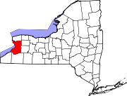
Towns Alden | Amherst | Aurora | Boston | Brant | Cheektowaga | Clarence | Colden | Collins | Concord | Eden | Elma | Evans | Grand Island | Hamburg | Holland | Lancaster | Marilla | Newstead | North Collins | Orchard Park | Sardinia | Tonawanda | Wales | West Seneca
Villages Akron | Alden | Angola | Blasdell | Depew | East Aurora | Farnham | Gowanda‡ | Hamburg | Kenmore | Lancaster | North Collins | Orchard Park | Sloan | Springville | Williamsville
CDPs Other
hamletsAkron Junction | Alden Center | Armor | Athol Springs | Bagdad | Bellevue | Big Tree | Blakeley | Blossom | Boston | Bowmansville | Brant | Brighton | Carnegie | Chaffee | Clarksburg | Cleveland Hill | Clifton Heights | Collins Center | Concord | Creekside | Crittenden | Dellwood | Derby | Doyle | Duells Corner | Dutchtown | East Amherst | East Concord | East Eden | East Elma | East Seneca | Ebenezer | Eden Valley | Eggertsville | Ellicott | Elma | Evans Center | Ferry Village | Footes | Forks | Fowlerville | Gardenville | Getzville | Glenwood | Grandyle Village | Green Acres | Griffins Mills | Holland | Hunts Corners | Jerusalem Corners | Jewettville | Kenilworth | Lake View | Langford | Lawtons | Locksley Park | Loveland | Marilla | Marshfield | Millersport | Millgrove | Morton Corners | Mount Vernon | Murrays Corner | New Ebenezer | New Oregon | North Bailey | North Evans | Oakfield | Patchin | Peters Corners | Pine Hill | Pinehurst | Pontiac | Porterville | Protection | Sand Hill | Sandy Beach | Scranton | Sheenwater | Shirley | Snyder | South Newstead | South Wales | Spring Brook | Swifts Mills | Taylor Hollow | Town Line Station | Swormville | Walden Cliffs | Wales Hollow | Wanakah | Water Valley | Webster Corners | Wende | West Alden | West Falls | Weyer | Williston | Windom | Wolcottsburg | Woodlawn | Woodside | Wyandale | Zoar
Indian
reservationsFootnotes ‡This populated place also has portions in an adjacent county or counties
Categories:- Towns in New York
- Buffalo – Niagara Falls metropolitan area
- Populated places in Erie County, New York


Wikimedia Foundation. 2010.