- Washington State Route 410
-
State Route 410
Chinook Scenic Byway 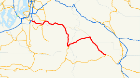
A map of the Cascade Range northeast of Mount Rainier and surrounding foothills with SR 410 highlighted in red.Route information Defined by RCW 47.17.610 Maintained by WSDOT Length: 107.44 mi[3] (172.91 km) Existed: 1967[1][2] – present Major junctions West end:  SR 167 in Sumner
 SR 165 in Buckley
 SR 164 in Enumclaw
 SR 123 at Cayuse Pass
East end:  US 12 in Naches
Location Counties: Pierce, King, Yakima Highway system State highways in Washington
Interstate • US • State
Former PSH • 1964 renumbering • Former SR←  SR 409
SR 411  →
→State Route 410 (SR 410, partially named the Chinook Scenic Byway) is a 107.44-mile (172.91 km) long state highway that traverses Pierce, King, and Yakima counties in the U.S. state of Washington. It begins at an interchange with SR 167 in Sumner and travels southeast across the Cascade Range to a junction with U.S. Route 12 (US 12) in Naches. While the western part of SR 410 is a freeway that serves built-up, urban areas, the remainder of the route is a surface road that traverses mostly rural areas as it passes through the mountains.
The route starts as a limited-access southerly bypass of Downtown Sumner, but becomes a surface road east of the city. Traveling eastward, the roadway serves Bonney Lake and Buckley, and crosses and eventually parallels the White River into Enumclaw and Greenwater. SR 410 enters the Mount Baker-Snoqualmie National Forest and later heads into Mount Rainier National Park, crossing the Cayuse and Chinook passes, and leaves the park southeast along the American River into Wenatchee National Forest. SR 410 leaves the national forest and travels parallel to the Naches River to end in Naches, a city located west of Yakima. The Chinook Scenic Byway begins in Enumclaw and follows the highway through the two national forests and Mount Rainier National Park to US 12 in Naches.
Modern SR 410 was parts of various state wagon roads until 1926 when US 410 was established, extending from Aberdeen to Lewiston, Idaho. US 410 was decommissioned after US 12 was extended over the majority of the highway in 1967, bypassing Olympia and Chinook Pass. A segment of former US 410 from Elma to Olympia became SR 8 and the Tacoma to Naches segment became SR 410. The highway was later shortened to end in Sumner and was replaced by SR 167 from Tacoma to Sumner.
Contents
Route description
SR 410 begins as a freeway at an interchange with SR 167 near Downtown Sumner.[4] The highway travels southeast across suburban areas, crossing the Stuck River and passing a partial cloverleaf interchange with Linden Drive,[5] also named Traffic Avenue. After a second partial cloverleaf interchange with Thompson Avenue, SR 410 goes under a railroad trestle owned by BNSF Railway and used by Amtrak's Cascades rail service,[6][7] near the northern bank of the Puyallup River.[5] After turning northeast, SR 410 encounters the western terminus of SR 162 by way of a diamond interchange. SR 162 travels north into Downtown Sumner as Valley Avenue and south over the Puyallup River towards Orting.[8] The freeway section near the interchange was the busiest recorded part of SR 410 in 2008 with a daily average of 59,000 motorists using the freeway.[9] Continuing northeast, SR 410 connects to 166th Avenue and turns southeast as an undivided highway into the community of Bonney Lake.[10] East of Bonney Lake, the roadway heads east, passing two shopping centers before entering Buckley and intersecting SR 165. In Buckley, the street travels northeast through Downtown and turns north to cross the White River and enter King County.[3][11]
After leaving Pierce County, the highway travels northeast through rural areas into Enumclaw and passes Enumclaw High School before turning east and being renamed Roosevelt Avenue.[3] As Roosevelt Avenue, the street intersects Griffin Avenue, also designated SR 164, which travels northwest to SR 169 and Auburn. The roadway, now named the Chinook Scenic Byway,[12] passes by the King County Fairgrounds and Enumclaw King County Park.[13][14][15] Leaving Enumclaw in a southeastern direction, SR 410 begins to parallel the White River upriver into Federation Forest State Park, a 619-acre (2.51 km2; 0.967 sq mi) state park consisting of old growth evergreen forests.[16][17] The highway crosses the Greenwater River, northeast of its confluence with the White River, and re-enters Pierce County.[3][11]

The bridge ends in the community of Greenwater, named for the river, where the roadway encounters Forest Road 70, which has been proposed to become SR 168 over Naches Pass as an alternative to the Chinook Scenic Byway.[18] From Greenwater, the road travels south alongside the White River into Mount Baker-Snoqualmie National Forest,[19] passing Ranger Creek State Airport, a state-owned airport that is open in the summer and early fall.[20] The byway travels south into Mount Rainier National Park and intersects SR 123 at Cayuse Pass.[21] SR 410 turns east at the intersection and heads through a series of hairpin turns, passing Tipsoo Lake, to Chinook Pass.[11]
Chinook Pass is the border between Pierce and Yakima counties and Mount Rainier National Park and the Wenatchee National Forest.[21][22] The pass is also where the highway crosses the Pacific Crest Trail, a National Scenic Trail that was completed in 1993.[23][24] East of Chinook Pass, the roadway begins to parallel the American River northeast to follow the Little Naches River, which becomes the Naches River.[22] After a junction with the other end of the proposed SR 168, named Little Naches Road, the highway exits the Wenatchee National Forest and enters Naches. The byway ends at US 12 in Naches near the Naches Selah Canal.[3][11]
History
 Several state roads from 1897 to 1923 that were in the vicinity of Chinook Pass.
The first portion of SR 410 that was defined under law to be built by the state of Washington was a state wagon road that extended from a county road in King County to a county road near Naches. The road ran up alongside the White River until it reached the summit of the Cascades and continued traveling down parallel to the American River before ending at the county road connecting to Naches. This road was approved and built in 1897, making it one of the oldest state roads in Washington state.[25] In 1905, the road became known as State Road 1 and was incorporated into the first state highway system.[26] By 1907, the road was named the White River – Natches Road and was shortened to end at Cedar Springs. The rest of the road was transferred to State Road 5, called the Cowlitz–Natches Road, which ran from Napavine to Naches.[27]
In 1913, the state highway system was adjusted again, and several new roads were added to the system, including parts of what would become US 410. The Olympic Highway traveled around the Olympic Peninsula and a section from Aberdeen to Olympia was later used as part of US 410.[28] The Pacific Highway would later have a brief concurrency with US 410 from Olympia to Tacoma, and US 410 would later connect to the National Park Highway in Tacoma and follow it to Burkley, where State Road 5, now a secondary highway maintained by the counties, began.[28] From the end of State Road 5 in Naches, the Inland Empire Highway is concurrent with the future US 410 to Dayton, where a branch of the highway travels to Clarkston.[28] State Road 5 became the McClellan Pass Highway in 1919 and was aligned further south to Chinook Pass.[29] The McClellan Pass Highway was renamed the Naches Pass Highway in 1921 to reflect the realignment in 1919.[30]
In 1923, the state highway system was restructured completely, incorporating numbers instead of names. The Olympic Highway became State Road 9, the Pacific Highway became State Road 1, the National Park Highway absorbed the Naches Pass Highway and remained State Road 5, and the Inland Empire Highway became State Road 3, but its branch from Dayton to Clarkston remained a branch of the now non-existent Inland Empire Highway.[31] A system of national highways that improved on the concept of auto trails was formed in late 1925. The final plan for the system—which became the U.S. routes—was approved on November 11, 1926. One of the routes included in the plan was US 410, which extended from US 101 in Aberdeen to US 95 in Lewiston, Idaho. Parts of US 410 were concurrent with other new highways, including US 99 from Olympia to Tacoma and US 97 in Yakima.[32] In 1937, the state highway system changed to a primary and secondary system. US 410 remained the same, but its concurrent state highways had their designations changed by the state. State Road 9 became Primary State Highway 9 (PSH 9), State Road 1 and US 99 became PSH 1, State Road 5 became PSH 5, State Road 3 became PSH 3, and the Inland Empire Highway branch from Dayton to Clarkston became a branch of PSH 3.[33]
In 1964, Washington unveiled a new numbering system for highways. Concurrencies with state primary state highways would be repealed in 1970 and US 410 would be a non-concurrent highway. On June 20, 1967, US 12 was extended west from Lewiston, Idaho, over White Pass to Aberdeen, eliminating most of the original route of the highway. The remaining sections were split amongst other routes. The segment from Elma to Olympia became State Route 8 (SR 8).[34][35] Interstate 5 (I-5) took the Olympia–Tacoma segment, and the Tacoma–Naches segment became SR 410.[1][2] The last reassurance markers for US 410 were taken down by December 1967.[36][37][38]
Originally, SR 410 passed through downtown Puyallup and Sumner, following several surface streets (including Main Avenue in Puyallup and Traffic Avenue and Main Street in Sumner) across the two cities. In the late 1960s, construction began on a limited-access bypass of the two city centers. SR 410 was moved onto the new freeway by 1972.[39][40] In 1973, SR 410 was shortened to its current length after SR 167 was extended to Tacoma.[1] On October 11, 2009, a massive landslide buried about 0.25 miles (0.40 km) of SR 410 west of Naches in the Nile Valley.[41] The landslide also blocked off the Naches River and caused warnings of severe flooding.[42] A detour was set up on Nile Road that was for residential use only until October 20.[43] SR 410 was permanently rerouted onto Nile Road sometime afterward,[44] and the Washington State Department of Transportation (WSDOT) completed paving on the new segment of SR 410 on November 20.[45][46]
Major intersections
County Location Mile[3] Destinations Notes Pierce Sumner 0.00 SR 167 (Valley Freeway) – Tacoma, Auburn, Renton0.48 Linden Drive (Traffic Avenue) / Thompson Avenue 1.56  SR 162 east (Valley Avenue) – Orting
Western terminus of SR 162 2.63 166th Avenue East / Sumner Tapps Highway East East end of freeway Buckley 11.84 SR 165 south – WilkesonNorthern terminus of SR 165 Bridge over White River King Enumclaw 15.98  SR 164 west (Griffin Avenue) to SR 169 north (Porter Street) – Auburn, Renton
Begin Chinook Scenic Byway 33.87 Bridge over Greenwater River Pierce Greenwater 35.96  FR 70 east – Naches Pass
Proposed SR 168 east 48.70 Mount Rainier National Park gate (entrance) Cayuse Pass 56.86 SR 123 south to US 12 – PackwoodNorthern terminus of SR 123 Chinook Pass 60.32 Chinook Pass Yakima Wenatchee NF 65.64 Mount Rainier National Park gate (entrance) 83.20 Little Naches Road – Naches Pass Proposed SR 168 west Naches 107.44 US 12 – Yakima, White Pass1.000 mi = 1.609 km; 1.000 km = 0.621 mi References
- ^ a b c Washington State Legislature (1970). "RCW 41.17.610: State route No. 410". http://apps.leg.wa.gov/RCW/default.aspx?cite=47.17.610. Retrieved October 21, 2009.
- ^ a b Weingroff, Richard F. (January 1, 2009). "U.S. 12 Michigan to Washington". Federal Highway Administration. http://www.fhwa.dot.gov/infrastructure/us12.cfm. Retrieved October 21, 2009.
- ^ a b c d e f Washington State Department of Transportation (2008). "State Highway Log: Planning Report, SR 2 to SR 971". http://www.wsdot.wa.gov/mapsdata/TDO/PDF_and_ZIP_Files/HwyLog2008.pdf. Retrieved October 21, 2009.
- ^ Washington State Department of Transportation (August 23, 2005). "SR 167; Junction SR 410". http://www.wsdot.wa.gov/mapsdata/tdo/Interchange/pdfs/SR167/167X007.pdf. Retrieved October 21, 2009.
- ^ a b Washington State Department of Transportation (August 6, 2001). "SR 410; Junction Linden Drive / Thompson Avenue". http://www.wsdot.wa.gov/mapsdata/tdo/Interchange/pdfs/SR410/410X009.pdf. Retrieved October 21, 2009.
- ^ Washington State Department of Transportation (2008). Washington State Rail System (Map). http://www.wsdot.wa.gov/NR/rdonlyres/1DFCBFA0-1A9D-4838-A74F-7841BF22E9C3/0/Railmap_update_Sept2008.pdf. Retrieved October 21, 2009.
- ^ Washington State Department of Transportation (2009). Amtrak Cascades Route (Map). http://www.wsdot.wa.gov/Freight/Rail/amtrakcascadesroutemap.htm. Retrieved October 21, 2009.
- ^ Washington State Department of Transportation (November 19, 1992). "SR 410; Junction SR 162 / Valley Avenue". http://www.wsdot.wa.gov/mapsdata/tdo/Interchange/pdfs/SR410/410X010.pdf. Retrieved October 21, 2009.
- ^ Washington State Department of Transportation (2008). "2008 Annual Traffic Report". http://www.wsdot.wa.gov/mapsdata/TDO/PDF_and_ZIP_Files/Annual_Traffic_Report_2008.pdf. Retrieved October 21, 2009.
- ^ Washington State Department of Transportation (June 22, 2005). "SR 410; Junction 166th Avenue E". http://www.wsdot.wa.gov/mapsdata/tdo/Interchange/pdfs/SR410/410X011.pdf. Retrieved October 21, 2009.
- ^ a b c d Google, Inc. Google Maps – State Route 410 (Map). Cartography by Google, Inc. http://maps.google.com/maps?f=d&source=s_d&saddr=47.201617,-122.255242&daddr=WA-410+W&hl=en&geocode=FVE90AIddoi2-A%3BFZlSyQIdYufM-A&mra=ls&sll=46.824966,-120.918961&sspn=0.329345,0.615921&ie=UTF8&z=9. Retrieved October 21, 2009.
- ^ National Scenic Byway Program. "Chinook Scenic Byway, Washington". http://www.byways.org/explore/byways/2226/. Retrieved October 21, 2009.
- ^ Enumclaw's King County Fair. "Enumclaw's King County Fair". http://www.enumclawskingcountyfair.com/. Retrieved October 21, 2009.
- ^ Enumclaw's King County Fair. "Enumclaw's King County Fair Directions". http://www.enumclawskingcountyfair.com/information/directionsmaps.html. Retrieved October 21, 2009.
- ^ City of Enumclaw Equestarian Country. Enumclaw Exposition Center Vincity Map (Map). http://www.enumclawskingcountyfair.com/images/expo-vicinity-map.pdf. Retrieved October 21, 2009.
- ^ Washington State Parks (2009). "Federation Forest State Park". http://www.parks.wa.gov/parks/?selectedpark=Federation+Forest. Retrieved October 21, 2009.
- ^ Washington State Parks (2009). Federation Forest State Park (Map). http://www.parks.wa.gov/parks/thumbnailAndmaps/8300042.pdf. Retrieved October 21, 2009.
- ^ Washington State Legislature (1970). "RCW 41.17.335: State route No. 168". http://apps.leg.wa.gov/RCW/default.aspx?cite=47.17.335. Retrieved October 21, 2009.
- ^ United States Forest Service (2008). Vincity Map of Mount Baker-Snoqualmie National Forest (Map). http://www.fs.fed.us/r6/mbs/maps/mt-baker-snoqualmie-national-forest-vicinity-map-2008.pdf. Retrieved October 21, 2009.
- ^ Washington State Department of Transportation. "Ranger Creek State Airport". http://www.wsdot.wa.gov/aviation/AllStateAirports/Greenwater_RangerCreekState.htm. Retrieved October 21, 2009.
- ^ a b National Park Service (2009). Mount Rainier National Park (Map). http://home.nps.gov/applications/parks/mora/ppMaps/ACFC070.pdf. Retrieved October 21, 2009.
- ^ a b United States Forest Service. Okanogan and Wenatchee National Forests (Map). http://www.fs.fed.us/r6/wenatchee/maps/oka-wen-location-map.jpg. Retrieved October 21, 2009.
- ^ United States Forest Service. "Pacific Crest National Scenic Trail". http://www.fs.fed.us/pct/index.html. Retrieved October 21, 2009.
- ^ United States Forest Service. "Washington Segment of the Pacific Crest Trail". http://www.fs.fed.us/pct/washington_segment.html. Retrieved October 21, 2009.
- ^ "Chapter 116". Session Laws of the State of Washington. Session Laws of the State of Washington (1897 ed.). Olympia, Washington: Washington State Legislature. March 18, 1897. pp. 342–345. http://books.google.com/books?id=2MY4AAAAIAAJ. Retrieved November 6, 2010.
- ^ "Chapter 7". Session Laws of the State of Washington. Session Laws of the State of Washington (1905 ed.). Olympia, Washington: Washington State Legislature. January 26, 1905. p. 20. http://books.google.com/books?id=R8g4AAAAIAAJ. Retrieved November 6, 2010.
- ^ "Chapter 151". Session Laws of the State of Washington. Session Laws of the State of Washington (1907 ed.). Olympia, Washington: Washington State Legislature. March 13, 1907. pp. 309–310. http://books.google.com/books?id=Isk4AAAAIAAJ. Retrieved November 6, 2010.
- ^ a b c "Chapter 65". Session Laws of the State of Washington. Session Laws of the State of Washington (1913 ed.). Olympia, Washington: Washington State Legislature. March 12, 1913. pp. 221–223. http://books.google.com/books?id=W7w4AAAAIAAJ. Retrieved November 6, 2010.
- ^ "Chapter 110". Session Laws of the State of Washington. Session Laws of the State of Washington (1919 ed.). Olympia, Washington: Washington State Legislature. 14. pp. 268–269. http://books.google.com/books?id=t704AAAAIAAJ1. Retrieved November 6, 2010.
- ^ "Chapter 32". Session Laws of the State of Washington. Session Laws of the State of Washington (1921 ed.). Olympia, Washington: Washington State Legislature. March 2, 1921. p. 118. http://books.google.com/books?id=Fb44AAAAIAAJ. Retrieved November 6, 2010.
- ^ "Chapter 185". Session Laws of the State of Washington. Session Laws of the State of Washington (1923 ed.). Olympia, Washington: Washington State Legislature. March 19, 1923. p. 627–630; 632. http://books.google.com/books?id=G784AAAAIAAJ. Retrieved November 6, 2010.
- ^ United States Department of Agriculture (November 11, 1926). United States System of Highways (Map).
- ^ "Chapter 190". Session Laws of the State of Washington. Session Laws of the State of Washington (1937 ed.). Olympia, Washington: Washington State Legislature. March 17, 1973. p. 933–938. http://books.google.com/books?id=dcQ4AAAAIAAJ. Retrieved November 6, 2010.
- ^ C. G. Prahl, Washington State Highway Commission (December 1, 1965). "Identification of State Highways, Part 1" (PDF). http://www.wsdot.wa.gov/NR/rdonlyres/6836215D-E301-43F3-895A-472BD2FDE86A/0/Identification.pdf. Retrieved November 6, 2010.
- ^ C. G. Prahl, Washington State Highway Commission (December 1, 1965). "Identification of State Highways, Part 2" (PDF). http://www.wsdot.wa.gov/NR/rdonlyres/EC2F7D1E-2F51-4004-B5C3-5A2CE9FE3C7D/0/Indentification2.pdf. Retrieved November 6, 2010.
- ^ "Highway 410 is now U.S. No. 12". Walla Walla Union-Bulletin: p. 1. December 28, 1967.
- ^ "U-B Action Line". Walla Walla Union-Bulletin: p. 1. September 29, 1968.
- ^ Washington State Highway Commission (1970). "Annual Traffic Report" (PDF). http://www.wsdot.wa.gov/mapsdata/tdo/PDF_and_ZIP_Files/1970_ATR.pdf. Retrieved November 6, 2010.
- ^ United States Geological Survey (1965). Seattle, 1965 (Map). 1:250,000. Cartography by United States Army Corps of Engineers. http://www.lib.utexas.edu/maps/topo/250k/txu-pclmaps-topo-us-seattle-1965.jpg. Retrieved 4 December 2010.
- ^ Union 76 (1972). Washington Oregon Road Map (Map). 1 in ≈ 17.3 mi (WA) / 1 in ≈ 20.9 mi (OR). Cartography by Rand McNally.
- ^ Doughton, Sandi (October 11, 2009). "Hwy 410 likely closed for winter after huge landslide". The Seattle Times (Seattle). http://seattletimes.nwsource.com/html/localnews/2010044629_webmudslide11m.html. Retrieved November 6, 2010.
- ^ "Flooding from Naches landslide still a threat". The Seattle Times. The Associated Press (Seattle). October 16, 2009. http://seattletimes.nwsource.com/html/localnews/2010079030_apwanacheslandslide1stldwritethru.html. Retrieved November 6, 2010.
- ^ Seattle Times staff (October 20, 2009). "Detour around Highway 410 landslide open to all". The Seattle Times (Seattle). http://seattletimes.nwsource.com/html/traffic/2010102817_webroute21m.html. Retrieved November 6, 2010.
- ^ Lester, David (November 2, 2009). "Landslide changes life in valley near Naches". The Seattle Times (Seattle). http://seattletimes.nwsource.com/html/localnews/2010186429_apwanacheslandslidenile.html. Retrieved November 6, 2010.
- ^ Washington State Department of Transportation (2009). "SR 410 - Nile Valley Landslide". http://www.wsdot.wa.gov/projects/sr410/landslide. Retrieved November 6, 2010.
- ^ Washington State Department of Transportation (2009). SR 410 - Nile Valley Landslide - Project Map (Map). http://www.wsdot.wa.gov/Projects/SR410/Landslide/Map.htm. Retrieved November 6, 2010.
External links
- Highways of Washington State: SR 410
- Highways of Washington State: US 410 (ddecommissioned)
- Chinook Scenic Byway
- SR 167 Interchange - WSDOT Traffic Camera
State highways in Washington related to SR 16 and SR 410 
 Former or proposed: SR 168Categories:
- State highways in Washington (state)
- U.S. Route 10
- U.S. Route 12
- Scenic highways in Washington (state)
- Transportation in Pierce County, Washington
- Transportation in King County, Washington
- Transportation in Yakima County, Washington
- Mount Rainier National Park


Wikimedia Foundation. 2010.